Utah’s snowpack is above average at median peak

SALT LAKE CITY (ABC4) — What started as a dry and somewhat disappointing winter in terms of snowfall and precipitation has turned a corner to become one of the better years for Utah’s snowpack.
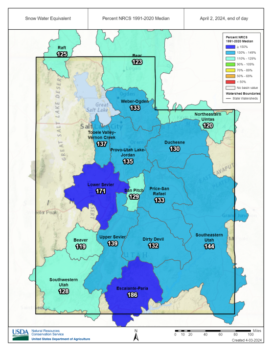
Utah’s snowpack typically hits its peak levels on April 3. After that, sunny days and rising temperatures start the runoff of much-needed water to the reservoirs and lakes.
This year, Utah’s snow water equivalent ran below average from October until the weather turned in mid-January. Once the weather started bringing snow and rain more frequently, Utah’s snow water equivalent rose to 131% of the median.
Reservoirs from across the state have also benefited from the late surge of moisture. According to the Department of Natural Resources, Utah’s reservoirs dropped to a collective capacity low of 73%. As of April, the reservoirs now sit at a healthy 84% with much of the runoff still left to come.
However, two good water years are still not enough for Utahns to slow down on water conservation efforts. During last year’s runoff of a historic snowfall, Great Salt Lake Coordinator for the Utah Division of Forestry, Fire and State Lands told ABC4 the water was just “a drop in the bucket” that only bought two more years max in the life of the lake.
As the lake’s future remains in question and Utah’s population continues to grow, officials say it’s becoming crucial to conserve even during “good water years.”
To learn how you can help conserve water and be “waterwise,” visit the Division of Water Resource’s website.
For the latest news, weather, sports, and streaming video, head to ABC4 Utah.

