US West Coast stormy siege with flooding rain, mudslides and yards of mountain snow to continue into midweek
A series of potent storms will slam much of the West Coast of the United States with rounds of drenching rain, heavy mountain snow, gusty winds and pounding surf through the middle of the week.
On Saturday night, heavy rain created flooding and road-blocking mudslides in the Los Angeles area as 60 to 70 mph winds buffeted Oregon and Washington. More than 300,000 customers lost power in Washington as the winds downed trees and power lines.
Following this storm, two additional storms will roll ashore.
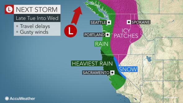
One storm will continue to blast northern and Central California into Monday morning and another storm will roll ashore Tuesday night and last into Wednesday. Heavy rain and mountain snow will continue to focus on northwestern Washington and British Columbia Wednesday through Thursday.

While the pattern will be a boon for the ski industry and go a long way toward drought relief, each successive storm will hinder travel and raise the risk of flash flooding, mudslides and avalanches.
Download the free AccuWeather app to view the details on each storm and any advisories that are issued for your location or points along your travel route.
The main bombardment of moisture from all of the storms and corresponding heaviest rain and mountain snow will be in Northern California, although rain and mountain snow will also extend to western Oregon, western Washington and British Columbia.
The cumulative amount of precipitation will be tremendous from the storm train in these areas.
Storms to unload inches of rain
Additional rainfall through Thursday on the western slopes of the Pacific Coast Ranges in Northern California, northern Sierra Nevada and Olympics will be on the order of 3-6 inches with locally higher amounts.
The risk from flash flooding and mudslides will increase with each storm, with the greatest potential for life-threatening conditions likely during the storm spanning late Tuesday to Wednesday. By then the ground will be saturated and the hillsides in recent burn areas are likely to be unstable.
People should heed all evacuation orders for their area, if given, as there may only be minutes to move to safety.
Motorists are reminded to not attempt to drive through flooded roads or around barriers. The water may be deeper than it appears and/or the road surfaces beneath the water may be weakened or washed away. A foot of water is enough to cause most vehicles to loose contact with the road. Two feet of water can cause even heavy vehicles to float into deeper water.
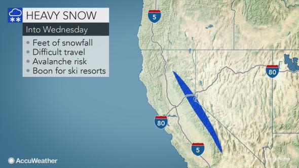
Feet and yards of snow forecast for the mountains
The storms will provide a tremendous boost to the snowpack, which then becomes much of the state's water supply during the warm season.
"Snowfall [from this weekend to midweek] is likely to be measured in yards over the high country of the northern Sierra Nevada and Cascades and peaks of the Olympics," according to AccuWeather Senior Meteorologist Dan Kottlowski.
As much as 8 to 10 feet of snow may pile up on the ridges and peaks of the Northern Sierra Nevada through Wednesday evening.
"Freezing levels will vary with each storm and have a profound effect on travel over Donner Summit, California, Siskiyou Summit, Oregon and Snoqualmie Pass, Washington," according to AccuWeather Senior Meteorologist Kristina Pydynowski.
"At this time, we expect rain and not snow to fall over the Grapevine in Southern California with the siege of storms," Pydynowski said.
During the storm at midweek, there should be too much warm air for snow at Siskiyou Summit. Any rain at the storm's onset should quickly change to snow and treacherous travel at Donner Summit.
Motorists should expect major delays and possible closures when venturing over the passes. Vehicles attempting to venture over the passes in these conditions must have the proper winter equipment.
Whiteouts are likely with each storm over the passes and high country, but the most drastic sudden change from wet to blizzard conditions and strong winds over the high passes is likely with the storm during Tuesday night and Wednesday.
"Farther north, there can be enough lingering cold air for snow or ice in some of the interior valleys of the Northwest with the midweek storm," Pydynowski added.
Dangerous conditions forecast from the storms
Gusts over some of the passes in the mountains may reach 90 mph with the storms.
Along with the heavy snow, varying snow levels and strong winds over the mountains will be an increasing risk of avalanches. Snowboarders, skiers and snowmobilers should use extreme caution when doing off-trail adventures over rugged terrain.
Large waves will pound the coast with the risk of overwash and coastal erosion. Never stand on jetties or the beach to watch the storm due to the risk of large, unpredictable sneaker waves.
Localized winds may be strong enough with any of the storms to knock down trees and cause sporadic power outages. Gusts in coastal areas from Northern California to Washington may reach 60 mph.
Travel time suggestions through the upcoming week
For those with travel plans, the period from Monday afternoon to Tuesday midday may offer an opportunity from storm-free conditions. However, a better and longer opportunity for travel is likely from Thursday to Friday.
Another dose of rain and mountain snow may roll in Friday night to Saturday. That storm may bring soaking rain and a risk of mudslides to parts of Southern California as well as Northern California.

