UK weather - live: Danger to life amber warning issued today amid heavy rain and thunderstorms

The Met Office has issued “danger to life” warnings as thunderstorms, heavy rain and flooding are set to hit the UK today.
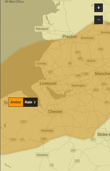
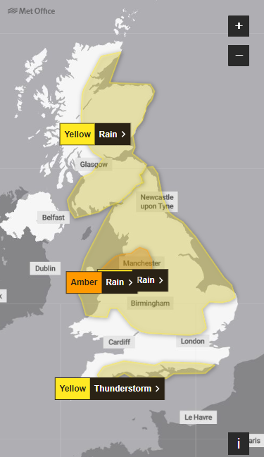
An amber warning for rain is in place for parts of north Wales and north-west England for 24 hours from noon on Wednesday.
Yellow rain warnings are also in place for much of Scotland, northern Ireland, the north of England, the Midlands and mid-Wales, while a yellow warning for thunderstorms has been issued for large swathes of the south coast from 8am to 7pm on Wednesday.
Met Office meteorologist Alex Burkill said: “Some areas are really going to see a lot of heavy, persistent rain through a big chunk of Wednesday. It is going to be a pretty wet picture as we go through the rest of the week for many places.
“There is some uncertainty as to exactly where we are going to see the heaviest rain and where is most likely to be impacted.”
Many places could see 30-40 mm of rain, while a few areas may receive 60-80 mm, the Met Office said. There is also a small chance that a few upland areas could see much higher totals, in the order of 150 mm.
Key Points
Met Office issues danger to life amber warning for heavy rain and flooding
‘Heavy, persistent rain’ to fall on Wednesday
Up to 30-40mm to fall within thee hours in south of England
What are the weather warnings in place?
14:15 , Maryam Zakir-Hussain
We are pausing updates on this liveblog. Thank you for tuning in.
What areas are affected by the amber weather warning?
13:53 , Maryam Zakir-Hussain
Here are the regions and local authorities affected by the amber warning for rain in place from noon today until noon tomorrow.
East Midlands
Derbyshire
North West England
Blackburn with Darwen
Cheshire East
Cheshire West and Chester
Greater Manchester
Halton
Lancashire
Merseyside
Warrington
Wales
Conwy
Denbighshire
Flintshire
Gwynedd
Wrexham
Yorkshire & Humber
West Yorkshire
One month’s rain could fall in next 24 hours
13:28 , Maryam Zakir-Hussain
A month’s worth of rain may fall within the next 24 hours in some parts of the UK, the Met Office has said.
It comes as six weather warnings for rain and thunderstorms are in place from today until tomorrow.
A month's worth of #rain may fall within the next 24 hours in some parts of the UK💦
Flooding is likely in places so stay #WeatherAware and up to date with the warnings 👇https://t.co/QwDLMfRBfs
Here's a look at how much #rain is expected⤵️ pic.twitter.com/GVNrbBhyPG— Met Office (@metoffice) May 22, 2024
Will the Bank Holiday weekend be a washout?
12:55 , Maryam Zakir-Hussain
A three-day weekend awaits most of us, but will we see showers or sunshine?
According to the Met Office, we’re still likely to see some rain on Friday, especially in the north, though there will some brighter spells in the south and east through the day.
“Later on Saturday, a front may move in from the Atlantic bringing a band of rain to Northern Ireland and western parts of Scotland. For many though, Saturday is likely to be a fair day, feeling warmer with temperatures slightly higher than average.
“Conditions are likely to change on Sunday though, as we see a return to more unsettled and showery weather.”
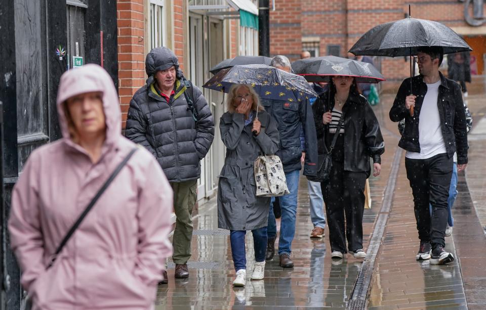
An ocean of umbrellas
12:25 , Maryam Zakir-Hussain
Pictures show people braving the rain as the Met Office issued multiple weather warnings for today.


Rainy hump day
11:55 , Maryam Zakir-Hussain
Showers of rain are set to fall this afternoon across large swathes of the UK.
In southern England, a warning for thunderstorms has also been issued. Despite the rain, temperatures remain mild as they hang in the mid-teens.
A wet afternoon for many of us. Heavy and persistent rain across Wales, the Midlands, northern England and Scotland with an increasing chance of some flooding in places⚠️
Heavy downpours and thunderstorms in southern England too⛈️
Windier and cooler than of late📉 pic.twitter.com/MSwHqMG2iZ— Met Office (@metoffice) May 22, 2024
Climate crisis is making UK winters even wetter, scientists warn
11:26 , Maryam Zakir-Hussain
Human-induced climate change has made downpours and rainfall across the UK and Ireland more intense with the region facing wetter winters in future, scientists warned.
The World Weather Attribution study found rainfall during storms across the UK and Ireland between October 2023 and March 2024 was made 20 per cent heavier by global warming.
The UK and Ireland saw 13 to 14 severe storms in 2023-24, which caused 13 deaths and widespread damage across the two countries - with similar heavy rainfall ten times more likely in future.

Winters in UK and Ireland are becoming even wetter due to climate crisis
Up to 150mm of rainfall likely to fall upon north Wales mountains
10:55 , Maryam Zakir-Hussain
⚠️⚠️ Amber weather warning issued ⚠️⚠️
Rain across northwest England and north Wales
Wednesday 1200 – Thursday 1200
Latest info 👉 https://t.co/QwDLMfRBfs
Stay #WeatherAware ⚠️ pic.twitter.com/C7vFv24yS0— Met Office (@metoffice) May 22, 2024
What are the weather warnings in place?
10:36 , Maryam Zakir-Hussain
Amber - Rain from 12pm today to 12pm tomorrow
Affecting: East Midlands, North West England, Wales, Yorkshire & Humber
Yellow - Rain 00.15 today to 12pm tomorrow
Affecting: East Midlands, East of England, London & South East England, North East England, North West England, South West England, Wales, West Midlands, Yorkshire & Humber
Yellow - Rain 5pm today to 10am tomorrow
Affecting: Highlands & Eilean Siar, Orkney & Shetland, Strathclyde
Yellow - Thunderstorm 8am to 7pm today
Affecting: London & South East England, South West England
Yellow - Rain 12pm today to 6pm tomorrow
Affecting: Central, Tayside & Fife, Grampian, Highlands & Eilean Siar, SW Scotland, Lothian Borders, Strathclyde
Yellow - Rain 5pm today to 10am tomorrow
Affecting: Northern Ireland
Up to 30-40mm to fall within thee hours in south of England
10:14 , Maryam Zakir-Hussain
In addition to the thunderstorm warning, which also includes scattered showers and the threat of spray on the roads and sudden flooding, the south of England could see heavy, thundery showers which could bring 30-40mm within three hours.
A Met Office spokeswoman said: “The precise track of the low pressure which would determine where the rainfall comes is still uncertain and is something we are keeping an eye on.
“We would encourage people to keep an eye on the forecast over the next couple of days to see how that evolves.”
‘Heavy, persistent rain’ to fall on Wednesday
10:13 , Maryam Zakir-Hussain
Met Office meteorologist Alex Burkill said: “Some areas are really going to see a lot of heavy, persistent rain through a big chunk of Wednesday. It is going to be a pretty wet picture as we go through the rest of the week for many places.
“There is some uncertainty as to exactly where we are going to see the heaviest rain and where is most likely to be impacted.”
The forecast says heavy and, in places, prolonged rainfall is expected from an area of low pressure arriving from the east, which has brought downpours to parts of central Europe.
Many places could see 30-40mm of rain, while a few areas may receive 60-80mm as heavy rain moves northwards throughout Wednesday. The Met Office said there is a small chance a few upland areas could see up to 150mm.
Met Office issues danger to life amber warning for heavy rain and flooding
10:12 , Maryam Zakir-Hussain
Heavy rain could bring flooding and travel disruption across much of the UK on Wednesday and Thursday with an amber warning issued for part of the country.
The Met Office has issued the amber warning for parts of north Wales and north west England, including Liverpool and Manchester, for 24 hours from noon on Wednesday.
The warning for the region says flooding and disruption are likely, with rain becoming heavy and persistent.
A yellow warning for rain is in place for the north of England, the Midlands and north and mid Wales until 6am on Thursday, with the southern edges of the affected area extended to run roughly from around Norwich to Bath.
Another yellow rain warning comes into place at noon on Wednesday for Scotland, covering the south and east of the country, which runs until 6pm on Thursday.
A further yellow warning for thunderstorms has been added for much of the south coast of England from 8am to 7pm on Wednesday.

