
The U.S. Is Covered in Wildfire Smoke
As of Wednesday morning, there are 65 major fires currently burning across the western United States, particularly in Oregon, California and Montana, where people are hoping that storms will bring a little rain to give firefighters a leg up. Even more fires are raging across western Canada.
But although almost 1.5 million acres in the U.S. are involved directly in the wildfires, the problem doesn't end there: Smoke from the fires has traveled 3,000 miles to reach the East Coast, as well. That's because of the jet stream, a strip of winds that acts like a conveyor belt circling the Earth from west to east over the northern United States.
The jet stream's incredible carrying power is on display in satellite images taken by NASA's Suomi satellite, which along with a network of other satellites, watches Earth's clouds, fires, hurricanes and blizzards in order to help meteorologists and other scientists know what phenomena might affect our lives.
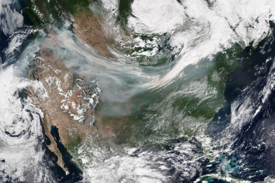
In the Suomi image, the bright white off the coast of California, south of the tip of Texas, and over eastern Canada is all cloud cover, as are the dustings across the Four Corners states and over Florida into the Atlantic. But the thinner, darker gray smear across Idaho, Wyoming, Nebraska and into the tip of clouds over the Great Lakes—that's all smoke.
And breathing in smoke is not particularly healthy, since it's full of tiny particles that can cause problems in your eyes and lungs. The worst impacts are still limited to the states directly affected by the fires: Almost all of Washington, Oregon, Idaho and Montana's air is currently classified as unhealthy, very unhealthy, or hazardous by the EPA.
Typically, smoke caught in the jet stream isn't dangerous, and the rest of the country is still at good or moderate air quality, despite the spread of the smoke.
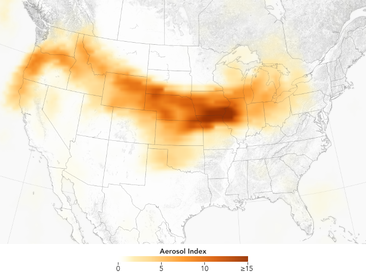
A similar phenomenon not visible in the satellite image is the spread along the same path of aerosols, which are tiny particles in the atmosphere that can later become the seeds of rainclouds. Like wildfires, volcanoes and dust storms can also cause upticks in aerosols. (The map, which is based on samples taken by a different instrument onboard the same satellite, shows only aerosol concentration at high altitudes, not what people experience on the surface of Earth.)
There's one tiny potential silver lining to a smoky sky: Sunsets and sunrises can be dyed still redder, as the smoke screens out bluer light from the sun.
Related Articles

