Two hurricanes on course for historic encounter with Big Island of Hawaii
UPDATE: Aug. 30, 2016, 5:24 p.m. EDT As of 5 p.m. EDT, Hurricane Madeline had maximum sustained winds of 115 miles per hour, making the storm a Category 3 on the Saffir-Simpson Scale. The NWS has issued a hurricane warning for the Big Island of Hawaii, meaning that hurricane conditions are expected there within 36 hours.
According to storm surge expert Hal Needham, the deep waters off the coast of Hawaii tends to contribute to higher waves when hurricanes or tropical storms pass nearby. However, storm surge flooding is also a concern with Hurricane Madeline, with about 4 feet of surge possible, Needham wrote, based on early estimates.
The Big Island of Hawaii is facing a serious threat from not one but two powerful hurricanes, either of which could become the first such storm to make landfall there since records began in 1949.
If both storms — Hurricanes Madeline and Lester — were to make landfall on the Big Island, it would be even more astounding compared to the island's hurricane history. However, this scenario currently appears unlikely.
SEE ALSO: Florida hurricane threat reveals forecasting challenges in social media era
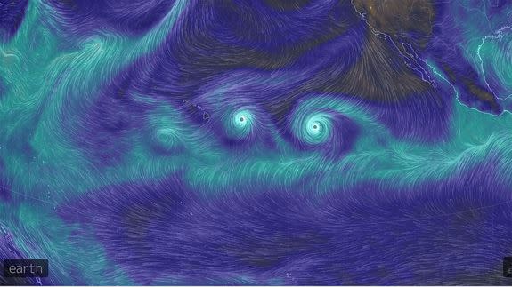
On satellite images and computer model simulations, the two storms are forming what appears to be a giant grimace in the Central Pacific, with the Intertropical Convergence Zone as the mouth.
Both storms are weakening as they approach the island, due to cooler ocean temperatures and interference from strong upper level winds.
However, even with a weakening trend, Hurricane Madeline, at least, looks poised to deliver a significant blow to the Big Island, and it could make landfall along the southern part of the island.
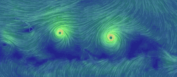
Image: earth.nullschool.net
The National Hurricane Center noted on Tuesday that the storm would likely be a minimal hurricane at the time of its closest pass to Hawaii, which should be Wednesday night into Thursday morning, local time.
The storm, which as of 8 a.m. HST had maximum sustained winds of 120 miles per hour, is forecast to curve to the west-southwestward when it makes its closest pass to the Big Island, which means that the side of the storm with the highest winds and greatest storm surge will lash the eastern and southeastern portions of the Big Island.
These areas are not heavily populated, with the famous Hawaii Volcanoes National Park and several forest reserves dotting the landscape.
The small towns of Ocean View and Naalehu will be closest to the center of circulation, based on the latest forecasts.
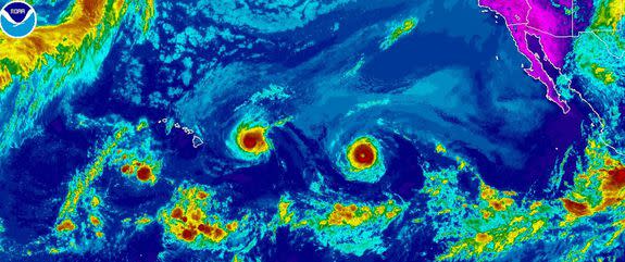
Image: noaa
The larger community of Kailua-Kona, with about 12,000 people, could see tropical storm to hurricane force winds, though it is on the western side of the island.
In addition, the weather and astronomy observatories located atop the 13,800-foot peak of Mauna Kea are likely to experience significant impacts from this storm in the form of high winds, in particular, as well has heavy rain.
The storm's impacts, which also include high surf, may spread to Maui, including Molokai and Lanai, where a tropical storm watch is in effect.
A tropical storm warning and a hurricane watch are in effect for Hawaii County, which encompasses the entire Big Island.
It is unlikely that Honolulu, Hawaii's capital and largest city, will see severe impacts from this storm. (President Obama is scheduled to visit Honolulu to address the IUCN World Conservation Congress on Wednesday night, local time.)
Hawaii, particularly the easternmost islands, is traditionally inhospitable territory for hurricanes due to relatively cool ocean waters that can weaken hurricanes and tropical storms.
However, these waters are milder than average for this time of year, which could aid in sustaining a storm as it moves closer to the islands.
Climate change is playing a role in warming ocean waters in the Pacific, as well as many other parts of the world's oceans. In addition, natural climate variability is resulting in warmer-than-average water temperatures which can help sustain stronger storms and allow them to threaten Hawaii more frequently.
Climate projections show that in a warmer world, Hawaii would be more vulnerable to tropical storms and hurricanes.
