Tropical Storm Ian likely to hit Cuba as Cat 4, as island issues hurricane watches
Tropical Storm Ian continued strengthening in the eastern Caribbean on Saturday — forecast to become a powerful Category 4 hurricane as it nears Cuba, then threatens Florida next week. Cuba has issued hurricane and tropical storm watches in anticipation.
Much of Florida remained in the cone as of the 11 p.m. forecast from the National Hurricane Center. But forecasters continued to nudge the track west throughout the day, taking much of South Florida out of it — from Palm Beach County to Monroe County.
Forecasters also cautioned that the track after 72 hours remained highly uncertain and a jog back to the east would also shift the cone along with it — along with wind from a storm expected to fuel up fast in hot western Caribbean waters.
“Users are urged to not focus on specific forecast intensities in the 4- and 5-day forecasts and instead focus on the potential hazards Ian may produce across portions of Florida,” the hurricane center said.
Jamie Rhone, acting director of the NHC, warned Floridians not to get fixated on the little changes in the track, which could just as easily move right back.
“You may think because you’re out of the cone, you’re out of the woods, and that’s not correct,” he said in a morning broadcast before the updated 5 p.m. cone was released. “You here in the South Florida peninsula have to maintain your guard.”
The 11 p.m. track called for a landfall Thursday night south of Tallahassee, along Florida’s sparsely populated Big Bend. That reflected the fourth hop west in the track.
No matter where Ian heads, heavy winds and rain could be felt across the state throughout the week. On Saturday afternoon, Gov. Ron DeSantis expanded his state of emergency declaration to the entire state, as the still-uncertain projected landfall track continues to wobble.
President Joe Biden also authorized FEMA to coordinate disaster relief efforts for those affected by Ian as he declared an emergency exists in the state.
The hurricane center, and officials in Miami-Dade and Monroe counties, urged residents to finish hurricane preparations by Monday evening. Emergency managers in the Florida Keys delayed a decision on whether to call for evacuations, planning to wait until Sunday morning amid the deep uncertainty around the storm’s Florida track.
READ MORE: Florida is in the storm cone. What it means for you and what you should be doing
The latest on Ian
Ian’s maximum sustained winds strengthened to 55 mph, according to the 11 p.m. update.
It was about 395 miles southeast of Grand Cayman and about 685 miles southeast of the western tip of Cuba. Ian continued to slow down a bit from the afternoon as it moves west at 13 mph.
Forecasters said the storm is now experiencing low sheer, high atmospheric moisture and is over superheated ocean water — setting the stage for rapid intensification into a hurricane while Ian moves over the northwestern Caribbean Sea.
Rapid intensification is when a storm gains at least 30 mph of sustained winds in a 24-hour period.
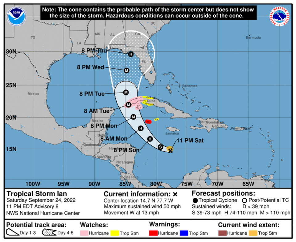
It’s currently projected to approach Cuba as a Category 4 hurricane with 130 mph winds, and continue to strength up to 140 mph winds in the warm waters of the Gulf. However, the latest guidance suggested Ian could weaken back down to a Category 2 before making landfall in Florida.
READ NEXT: Your 2022 survival guide to tropical storms, hurricanes in Miami, Broward and the Keys
Where in Florida?
Ian’s approach to Florida’s west coast early next week is still unclear, despite a trend west most of the day Saturday that moved Southeast Florida even more out of the cone.
The hurricane center said Saturday global modals are leaning toward a scenario where Ian will hit very strong southwesterly wind shear and weaken before approaching the Florida panhandle. However, forecasters say the potential impact of the storm should be focused on, not the track.
“Ian is likely to have an expanding wind field and will be slowing down by that time, which will have the potential to produce significant wind and storm surge impacts despite any potential weakening,” the hurricane center said.
Super-ensemble mean plots from @burgwx show a third consecutive cycle of a westward shift with the track of #TropicalStormIan in the models.
The 00z cycle will be key, as it will include new lower-level and upper-level observations of #Ian from @NOAA_HurrHunter and @53rdWRS. pic.twitter.com/brXuGoY021— weathertiger.substack.com - WeatherTiger, LLC (@wx_tiger) September 25, 2022
Michael Lowry, WPLG’s meteorologist, wrote in his newsletter that the storm’s center on Saturday morning was a little south of where previous models expected it to be, which could have consequences for a Florida landfall later next week.
“While we anticipated a brief turn westward, the southwesterly jog may indicate a competition ongoing between Ian’s mid-level center being blown southwestward by persistent wind shear and its formative low-level circulation chasing it,” he wrote. “The uneven distribution of thunderstorm activity south of the center could work to tug the system farther south and west in the short term.”
Preps this weekend are based on the latest NHC track & timing. Here's a rough idea of where we are right now. This could change based on new advisories. At a minimum, much of Florida should at least prepare for power outages, based on the NHC forecast track. pic.twitter.com/liOUYDvurP
— Craig Setzer (@CraigSetzer) September 24, 2022
One important factor in where exactly the storm goes is the ridge of air over the Northeast U.S. Models differ on when exactly it will begin to push south, and where it will steer Ian depends on when the storm interacts with that low pressure.
To help gather more information about that ridge, the National Weather Service in Aberdeen, South Dakota tweeted that dozens of NWS offices across the US are launching extra weather balloons, starting Saturday.
“Small changes in the track can make a BIG difference in impacts across South Florida,” the Miami NWS office warned.
The ‘cone of uncertainty’ is getting smaller — but it still matters if you’re outside it
Wind and rain predictions
South Florida and the Keys could see heavy rains beginning as early as Monday, along with some flooding. Current projections call for about 2 to 4 inches of rain across the Keys and southern Florida, the hurricane center said.
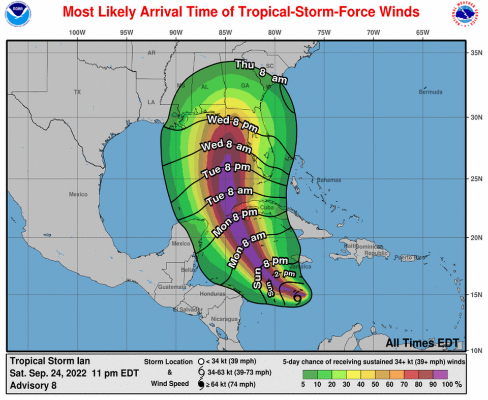
Tropical storm conditions are expected to begin on Sunday night in Grand Cayman, with hurricane conditions being felt early Monday.
The NHC predicts that Jamaica and the Cayman Islands could see three to six inches of rain, with some areas seeing maximums of 8 inches.
In Cuba, tropical storm conditions are possible by late Monday, with hurricane conditions being felt by Monday night or Early Tuesday. Western Cuba is forecast to receive about four to eight inches, with some regions seeing up to a foot of rain.
“These rains may produce flash flooding and mudslides in areas of higher terrain, particularly over Jamaica and Cuba. Flash and urban flooding is possible with rainfall across the Florida Keys and the Florida peninsula through mid next week,” the hurricane center said.
Three other systems
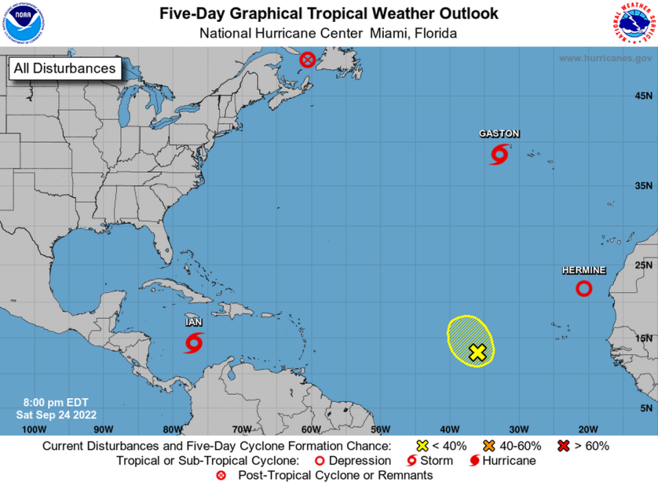
NHC was also monitoring three other systems, plus a tropical wave in the central Atlantic with a low chance of formation this week. By Saturday evening, Tropical Storm Hermine was downgraded to a depression and Tropical Storm Gaston pulled away from the Azores Saturday. Post-tropical Cyclone Fiona lashed Nova Scotia and Newfoundland with record-breaking winds and was expected to dissipate early next week as it approached Greenland.

