Tropical Cyclone Nora intensifies off Australia's northern coast
While Australia's been dealing with the year's strongest storm on one side of the country, another tropical cyclone is ramping things up in the north.
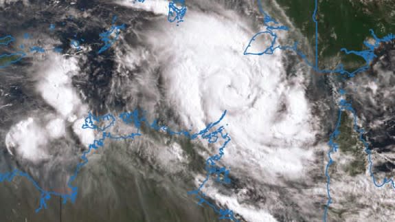
Category 2 Tropical Cyclone Nora continues to intensify toward a Category 3, reports the Bureau of Meteorology, and is moving in a southeasterly path towards the Gulf of Carpentaria.
SEE ALSO: The strongest storm of 2018 is swirling in the Indian Ocean
Officially named on Friday morning, Nora formed off the coast of the Northern Territory around 4 a.m. Since then, it's picked up intensity, and warning zones have been identified from Elcho Island to Cape Shield, including Nhulunbuy and Pormpuraaw to Thursday Island, including Weipa.
Category 2 Tropical Cyclone Nora, continues to intensify, and has started taking a more southeastrely track. Check https://t.co/rVLE6i5J4y for latest Watch and Warning areas. pic.twitter.com/OJWRSQvWFh
— Bureau of Meteorology, Queensland (@BOM_Qld) March 23, 2018
Gale force winds in the area are expected to reach anywhere between 60 to 93 miles (96 to 150 km) per hour, and heavy rainfall is expected, so abnormally high tides could happen. Flood warnings have been issued for the east coast north of Townsville, Cape York Peninsula and the Gulf Rivers extending west to the Northern Territory border.
⚠SEVERE WEATHER UPDATE: Tropical #CycloneNora in NT and Qld. Video current at 12pm ACST 23 March 2018. For latest information: https://t.co/rObDy3dlbP @secureTerritory | @ntpfes | @QldFES | @QldPolice pic.twitter.com/suQgBjHupc
— Bureau of Meteorology, Australia (@BOM_au) March 23, 2018
BOM reports Nora could reach Category 3 over the weekend, and by Sunday is likely to be located over the central or southern Gulf of Carpentaria. Possible landfall could happen in Saturday or Sunday south of Weipa.
#CycloneNora is looking impressive in the Arafura Sea with a good chance of developing to severe strength in the Gulf of Carpentaria. Before heading anywhere check the warnings at https://t.co/0FuHXrAYIk pic.twitter.com/ww11HfS6hd
— Bureau of Meteorology, Northern Territory (@BOM_NT) March 23, 2018
#CycloneNora is cranking! Already a Cat 2 and expected to reach Cat 3 tomorrow. View some awesome satellite imagery here (use the 'layers' button to adjust the view) https://t.co/7gduifB6gq pic.twitter.com/qA3QdmBrF7
— Bureau of Meteorology, Northern Territory (@BOM_NT) March 23, 2018
WATCH: Measuring ingredients just got easier with this smart scale