Tornadoes. Hail. Near record-high temps. Cold front. That's Florida's forecast this week
It's April but someone forgot to tell Mother Nature.
Yet another cold front is expected to move into Florida this week, but not before near-record-high temperatures are possible across south Central Florida.
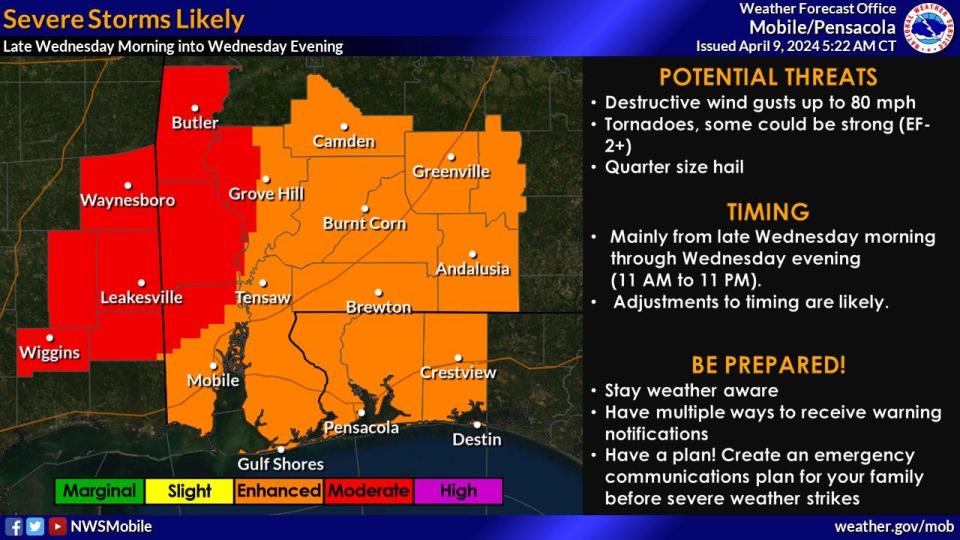
Severe storms are possible Wednesday into Thursday as the front moves down the state. Some of the storms could bring wind gusts up to 80 mph, strong tornadoes and quarter-sized hail, according to the National Weather Service Mobile.
Some of the tornadoes could be EF-2 or higher, NWS forecasters said. An EF-2 tornado has wind speeds of 111 to 135 mph.
The threat for tornadoes will ramp up Wednesday and Wednesday night, particularly along the Gulf Coast, according to AccuWeather.
The storms are part of a weather system moving east from the south central U.S.
Weather watches and warnings issued across the U.S.
Weather alerts issued in Florida
Florida weather forecast: What to expect and when
The storms are forecast to move into the western Panhandle late Wednesday morning and last well into evening. Weather will deteriorate farther south Wednesday into Thursday night.
Weather threats around Florida include:
Destructive wind gusts up to 80 mph.
Tornadoes, some of which could be strong, EF-2+.
Quarter-size hail.
Minor coastal flooding.
Life-threatening high surf.
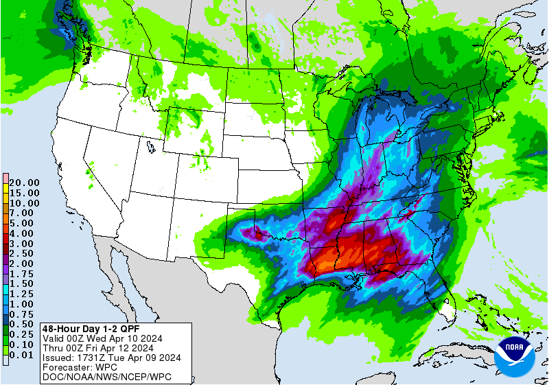
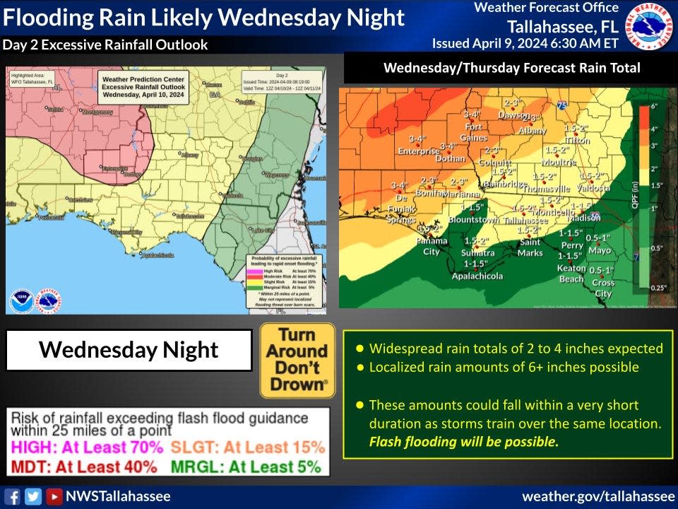
2-4 inches of rain over parts of the Panhandle; up to 6 inches in some areas.
Live weather radar for Pensacola, Fort Walton Beach

Weather forecast for Pensacola
Potential threats:
Destructive wind gusts up to 80 mph.
Tornadoes, some of which could be strong, EF-2+.
Quarter-size hail.
Watches and warnings:
High surf warning: until 1 a.m. CDT Friday. Dangerously large breaking waves of 5 to 9 feet expected in the surf zone.
High rip current risk: through late Thursday. Life-threatening rip currents expected.
Forecast:
Wednesday: A chance of showers and thunderstorms between 10 a.m. and 4 p.m., then showers and possibly a thunderstorm after 4 p.m. Some of the storms could be severe. High near 73. Breezy, with a southeast wind 10 to 20 mph, with gusts as high as 30 mph. Chance of precipitation is 80%. New rainfall amounts between a half and three quarters of an inch possible.
Wednesday night: Showers and possibly a thunderstorm before 1 a.m., then showers and thunderstorms likely between 1 a.m. and 4 a.m., then showers likely and possibly a thunderstorm after 4 a.m. Some of the storms could be severe and produce heavy rainfall. Low around 65. Windy, with a south wind 20 to 25 mph, with gusts as high as 40 mph. Chance of precipitation is 100%.
Thursday: A chance of thunderstorms before 7 a.m. Some of the storms could be severe. Mostly sunny, with a high near 72. West wind around 15 mph, with gusts as high as 25 mph. Chance of precipitation is 30%.
Thursday night: Clear, with a low around 56. Northwest wind 10 to 15 mph.
Friday: Sunny, with a high near 74. Northwest wind around 10 mph.
Friday night: Mostly clear, with a low around 54. West wind 5 to 10 mph becoming north after midnight.
Follow National Weather Service Mobile on X, formerly known as Twitter
Live weather radar for Tallahassee, Panama City
Weather forecast for Tallahassee
Potential threats:
2-4 inches of rain, in excess of 6 inches in some areas.
Flash flooding possible.
Severe thunderstorms.
Strong winds.
Minor coastal flooding.
Life-threatening high surf.
North Florida weather forecast: Tornadoes, wind, heavy rain possible with storm system forecast to hit North Florida
Watches and warnings: None issued at this time but a flood watch is likely later today, according to the National Weather Service Tallahassee.
A strong storm system is forecast to move into the region on Wednesday evening and exit the area by Thursday afternoon.
Forecast:
Wednesday: Mostly cloudy, with a high near 81. South wind 10 to 15 mph.
Wednesday night: A slight chance of showers before 11 p.m., then a chance of showers and thunderstorms between 11 p.m. and 2 a.m., then showers and possibly a thunderstorm after 2 a.m. Some of the storms could be severe. Low around 67. Breezy, with a south southeast wind 15 to 20 mph, with gusts as high as 30 mph. Chance of precipitation is 80%.
Thursday: Showers and thunderstorms, mainly before 2 p.m. Some of the storms could be severe. High near 80. Breezy, with a south wind 15 to 20 mph, with gusts as high as 30 mph. Chance of precipitation is 90%.
Thursday night: Mostly clear, with a low around 54. Breezy.
Friday: Sunny, with a high near 76.
Friday night: Clear, with a low around 51.
Follow the National Weather Service Tallahassee on X, formerly known as Twitter
Weather radar for Jacksonville, Gainesville, St. Augustine, Ocala, Palm Coast

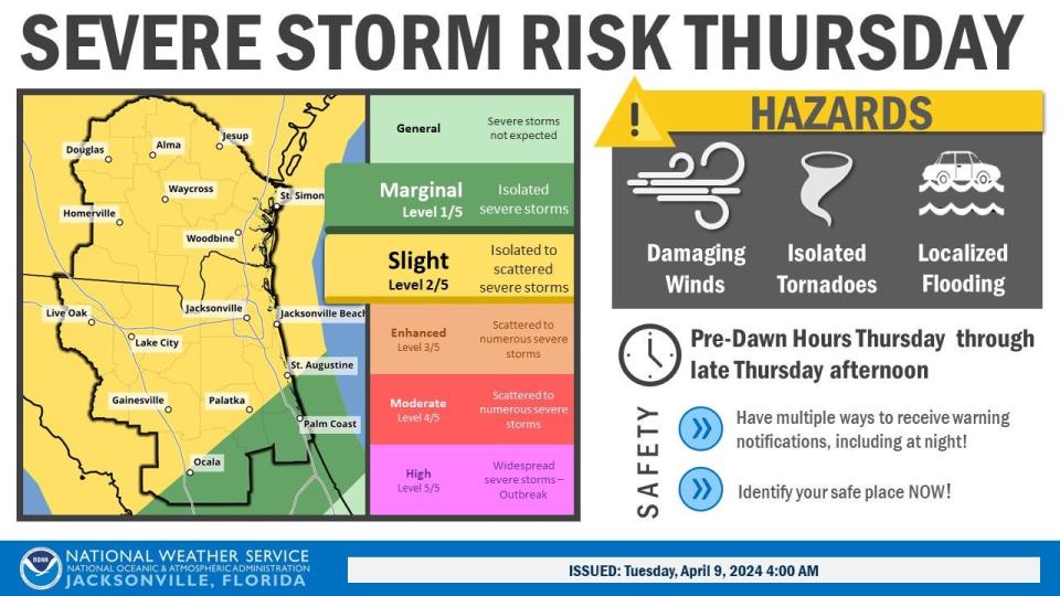
Weather forecast for Jacksonville
Threats:
Damaging winds in pre-dawn hours Thursday through Thursday afternoon.
Isolated tornadoes.
Localized flooding.
Forecast:
Wednesday: Partly sunny, with a high near 80. Breezy, with a south wind 10 to 18 mph, with gusts as high as 28 mph.
Wednesday night: Mostly cloudy, with a low around 72. Windy, with a southeast wind 18 to 20 mph, with gusts as high as 30 mph.
Thursday: A chance of showers and thunderstorms before 8 a.m., then showers likely and possibly a thunderstorm between 8 a.m. and 2 p.m., then showers and thunderstorms after 2 p.m. Some storms could be severe, with damaging winds and heavy rain. High near 80. Very windy, with a south wind 23 to 25 mph, with gusts as high as 38 mph. Chance of precipitation is 90%.
Thursday night: Showers and thunderstorms before 8 p.m. Some of the storms could be severe. Low around 58. Windy. Chance of precipitation is 80%.
Friday: Sunny, with a high near 78. Breezy.
Friday night: Clear, with a low around 55. Breezy.
Follow the National Weather Service Jacksonville on X, formerly known as Twitter
Weather radar for Daytona Beach, Melbourne, Stuart

Weather forecast for Daytona Beach
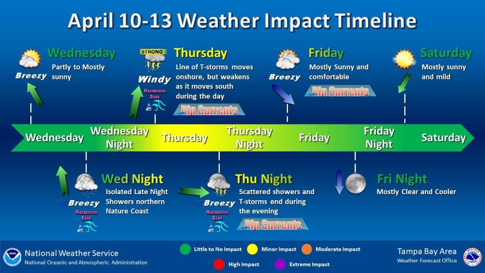
On Thursday, a cold front will approach the state from the west. As it does, windy conditions are forecast with gusts to around 35 to 40 mph possible in the afternoon. Near-record early-season hot temperatures in the lower 90s are forecast for southeast of Greater Orlando.
Scattered to numerous showers and isolated lightning storms are then expected by Thursday evening as the front arrives. A few storms could contain gusty winds to 55 mph along with brief torrential rain.
Forecast:
Wednesday: A 20 percent chance of showers before 2 p.m. Partly sunny, with a high near 82. Southeast wind 10 to 15 mph, with gusts as high as 20 mph.
Wednesday night: Partly cloudy, with a low around 70. South southeast wind around 15 mph, with gusts as high as 25 mph.
Thursday: A 40 percent chance of showers and thunderstorms after 2 p.m. Mostly sunny, with a high near 91. Windy, with a south wind 15 to 20 mph, with gusts as high as 25 mph.
Thursday night: A 30 percent chance of showers and thunderstorms before 2 a.m. Partly cloudy, with a low around 62. Windy, with a southwest wind 15 to 20 mph, with gusts as high as 25 mph.
Friday: Sunny, with a high near 80. North northwest wind 10 to 15 mph.
Friday night: Clear, with a low around 60. Northwest wind around 10 mph.
Follow the National Weather Service Melbourne on X, formerly known as Twitter
Weather forecast for Melbourne
Wednesday: A 20 percent chance of showers before 2 p.m. Partly sunny, with a high near 82. Southeast wind 10 to 15 mph, with gusts as high as 20 mph.
Wednesday night: Partly cloudy, with a low around 70. South southeast wind around 15 mph, with gusts as high as 25 mph.
Thursday: A 40 percent chance of showers and thunderstorms after 2 p.m. Mostly sunny, with a high near 91. Windy, with a south wind 15 to 20 mph, with gusts as high as 25 mph.
Thursday night: A 30 percent chance of showers and thunderstorms before 2 a.m. Partly cloudy, with a low around 62. Windy, with a southwest wind 15 to 20 mph, with gusts as high as 25 mph.
Friday: Sunny, with a high near 80. North northwest wind 10 to 15 mph.
Friday night: Clear, with a low around 60. Northwest wind around 10 mph
Follow the National Weather Service Melbourne on X, formerly known as Twitter
Weather forecast for Port St. Lucie
Wednesday: A 20 percent chance of showers. Partly sunny, with a high near 84. Southeast wind 10 to 15 mph, with gusts as high as 20 mph.
Wednesday night: Partly cloudy, with a low around 70. Southeast wind around 15 mph, with gusts as high as 20 mph.
Thursday: A 20 percent chance of showers and thunderstorms after 2 p.m. Mostly sunny, with a high near 92. Windy, with a south southeast wind 15 to 20 mph, with gusts as high as 25 mph.
Thursday night: A 40 percent chance of showers and thunderstorms, mainly after 8 p.m. Mostly cloudy, with a low around 63. Windy, with a southwest wind 15 to 20 mph, with gusts as high as 25 mph.
Friday: Sunny, with a high near 83. Northwest wind 10 to 15 mph, with gusts as high as 20 mph.
Friday night: Clear, with a low around 59. East northeast wind 5 to 10 mph becoming north northwest after midnight.
Follow the National Weather Service Melbourne on X, formerly known as Twitter
Weather radar for West Palm Beach, Naples

Weather forecast for West Palm Beach
Chances for isolated thunderstorms return later this week as a front approaches the area.
Forecast:
Wednesday: Mostly sunny, with a high near 79. Windy, with a southeast wind 22 to 25 mph.
Wednesday night: Mostly cloudy, with a low around 76. Windy, with a southeast wind 24 to 30 mph, with gusts as high as 33 mph.
Thursday: Mostly sunny, with a high near 85. Windy, with a south wind 26 to 28 mph, with gusts as high as 31 mph.
Thursday night: A 40 percent chance of showers and thunderstorms, mainly after 2 a.m. Mostly cloudy, with a low around 69. Windy, with a south wind 20 to 25 mph, with gusts as high as 28 mph.
Friday: A 30 percent chance of showers before 8 a.m. Mostly sunny, with a high near 78. Breezy, with a north wind 16 to 20 mph.
Friday night: Mostly clear, with a low around 67. Breezy, with a northeast wind 10 to 16 mph becoming north after midnight.
Follow the National Weather Service Miami on X, formerly known as Twitter
Weather forecast for Naples
Increasingly dry air moving in over the area late this week could lead to heightened fire weather concerns across interior and Southwest Florida.
Forecast:
Wednesday: Mostly sunny, with a high near 85. Southeast wind 10 to 14 mph, with gusts as high as 21 mph.
Wednesday night: Mostly clear, with a low around 73. Southeast wind 10 to 13 mph, with gusts as high as 20 mph.
Thursday: A 20 percent chance of showers and thunderstorms after 2 p.m. Partly sunny, with a high near 84. Breezy, with a south wind 14 to 18 mph, with gusts as high as 29 mph.
Thursday night: A slight chance of showers and thunderstorms before 11 p.m., then a slight chance of showers between 11 p.m. and 2 a.m. Mostly cloudy, with a low around 67. Southwest wind 9 to 13 mph becoming northwest after midnight. Winds could gust as high as 20 mph. Chance of precipitation is 20%.
Friday: Sunny, with a high near 81. North wind 10 to 13 mph, with gusts as high as 18 mph.
Friday night: Clear, with a low around 62. North wind around 14 mph, with gusts as high as 22 mph.
Follow the National Weather Service Miami on X, formerly known as Twitter
Weather radar for Sarasota, Fort Myers, Lakeland

Weather forecast for Fort Myers
Threats: A line of thunderstorms is expected to move into the Nature Coast Thursday morning. Isolated storms may be strong to severe, especially north of Interstate 4.
Forecast:
Wednesday: Mostly sunny, with a high near 89. East southeast wind 8 to 11 mph.
Wednesday night: Mostly clear, with a low around 71. Southeast wind 8 to 10 mph.
Thursday: A 30 percent chance of showers and thunderstorms after 3 p.m. Partly sunny, with a high near 87. Windy, with a south southeast wind 13 to 18 mph increasing to 20 to 25 mph in the afternoon. Winds could gust as high as 37 mph.
Thursday night: A 30 percent chance of showers and thunderstorms, mainly before 9 p.m. Mostly cloudy, with a low around 64. Breezy, with a southwest wind 13 to 18 mph, with gusts as high as 28 mph.
Friday: Sunny, with a high near 83. North wind around 11 mph.
Friday night: Clear, with a low around 59. Northwest wind 11 to 13 mph, with gusts as high as 18 mph.
Follow the National Weather Service Tampa Bay on X, formerly known as Twitter
Weather forecast for Sarasota
Wednesday: Mostly sunny, with a high near 81. Breezy, with an east southeast wind 14 to 18 mph, with gusts as high as 21 mph.
Wednesday night: Partly cloudy, with a low around 74. Breezy, with a south southeast wind 13 to 15 mph, with gusts as high as 22 mph.
Thursday: A chance of showers and thunderstorms between 9 a.m. and 3 p.m., then showers likely and possibly a thunderstorm after 3 p.m. Partly sunny, with a high near 79. Windy, with a south southeast wind 20 to 29 mph, with gusts as high as 43 mph. Chance of precipitation is 60%.
Thursday night: Showers likely and possibly a thunderstorm before 9 p.m. Partly cloudy, with a low around 66. Windy, with a west southwest wind 14 to 21 mph becoming northwest after midnight. Winds could gust as high as 32 mph. Chance of precipitation is 60%.
Friday: Sunny, with a high near 75. North northwest wind around 14 mph, with gusts as high as 20 mph.
Friday night: Clear, with a low around 63. Northwest wind 11 to 13 mph, with gusts as high as 18 mph.
Follow the National Weather Service Tampa Bay on X, formerly known as Twitter
This article originally appeared on Treasure Coast Newspapers: Florida weather forecast calls for cold front, strong tornadoes, hail
