Tornadoes, hail, gusty winds, heavy rain all possible as storm system moves across Florida
The next couple of days could bring some severe weather to several areas of Florida, including the possible for tornadoes and hail.
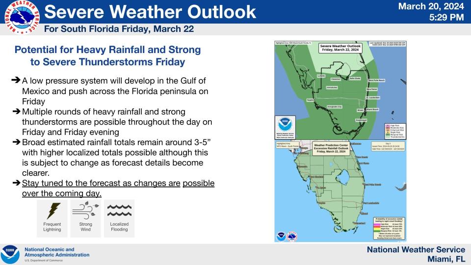
A system of low pressure is forecast to bring rain to much of the Sunshine State. Showers and thunderstorms will build Thursday night and into Friday, and could bring severe weather and flash flooding across Florida Friday, according to the Florida Division of Emergency Management.
Winds will strengthen throughout the day Thursday, with gusts generally reaching up to 10-20 mph. Locally stronger wind gusts upwards of 20-30 mph will be possible at times along the Treasure Coast, Gold Coast, and Keys.
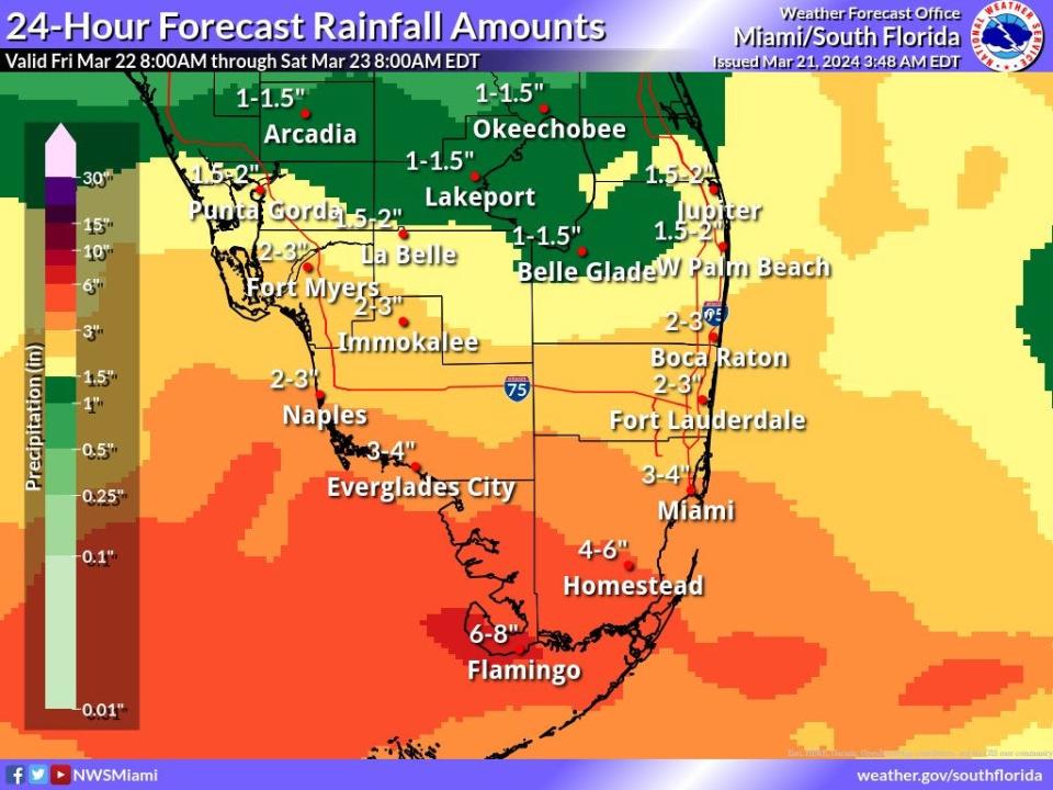
The National Weather Service in Miami warned periods of heavy rain are expected Friday and Friday night. The highest accumulations are likely to be along and south of Alligator Alley, where 3 to 6 inches is possible, with locally higher amounts.
Weather alerts issued in Florida
Weather radar and forecast for Pensacola

A storm or two near the immediate coast could potentially be capable of producing marginally severe hail or gusty winds Friday but severe potential will probably remain confined south of the coast, according to the National Weather Service Mobile. Scattered to numerous showers along with a few thunderstorms will linger into the evening hours with rain chances slowly decreasing into late Friday night.
Highs Friday trend slightly cooler in the mid 60s to near 70 degrees. Lows Friday night range between 50-55 over most locations except for readings in the upper 50s to near 60 degrees along the immediate coast and beaches.
Weekend forecast
Friday: Showers likely, with thunderstorms also possible after 10 a.m. Mostly cloudy, with a high near 69. East wind 10 to 15 mph becoming south in the afternoon. Winds could gust as high as 25 mph. Chance of precipitation is 70%. New rainfall amounts between a quarter and half of an inch possible.
Saturday: Partly sunny, with a high near 71. Breezy, with a north wind 10 to 15 mph increasing to 15 to 20 mph in the afternoon. Winds could gust as high as 30 mph.
Sunday: Sunny, with a high near 70. North wind 10 to 15 mph becoming southeast in the afternoon.
Follow National Weather Service Mobile on X, formerly known as Twitter
Weather radar and forecast for Tallahassee

Multiple rounds of showers and thunderstorms will be possible Friday into Saturday, according to the National Weather Service, Tallahassee. Additional showers and storms are forecast to develop through the day Friday, and some could be strong to severe.
Widespread 1 to 2 inches of rain with isolated higher amounts will be possible with this system. Widespread flooding is not expected, but a few spots of isolated flooding and/or additional rises on area rivers will be possible.
Weekend forecast
Friday: Showers and possibly a thunderstorm. High near 71. East wind 10 to 15 mph. Chance of precipitation is 80%. New rainfall amounts between a quarter and half of an inch possible.
Saturday: A 40 percent chance of showers and thunderstorms. Partly sunny, with a high near 74. West southwest wind 5 to 10 mph becoming northwest in the afternoon.
Sunday: Sunny, with a high near 74.
Follow the National Weather Service Tallahassee on X, formerly known as Twitter
Weather radar and forecast for Jacksonville

Rain showers and isolated thunderstorms are expected Friday morning for Northeast Florida, according to the National Weather Service, Jacksonville. Coverage will increase into the afternoon. The Storm Prediction Center has issued a general thunderstorm risk for the Southeast, with higher chances of severe weather occurring farther south, particularly south of I-4.
Chances for severe thunderstorms are not expected but isolated storms south of I-10 may be of the strong variety with some thunderstorm wind gust of 40 to 50 mph and small hail. That should be few and far between.
Rain will continue into Saturday as an upper-level trough moves across the region.
Weekend forecast
Friday: Showers and thunderstorms before 2 p.m., then rain between 2 p.m. and 5 p.m., then showers and possibly a thunderstorm after 5 p.m. High near 69. Windy, with a southeast wind 7 to 12 mph increasing to 15 to 20 mph in the afternoon. Winds could gust as high as 30 mph. Chance of precipitation is 90%. New rainfall amounts between a quarter and half of an inch possible.
Saturday: A chance of showers and thunderstorms, then showers likely and possibly a thunderstorm after 2 p.m. Partly sunny, with a high near 78. Southwest wind 8 to 13 mph, with gusts as high as 20 mph. Chance of precipitation is 60%.
Sunday: Mostly sunny, with a high near 67. Windy.
Follow the National Weather Service Jacksonville on X, formerly known as Twitter
Weather radar and forecast for Daytona Beach

Rain chances increase early Friday with only a slight chance of thunderstorms mainly south of Orlando. There is potential for isolated strong storms on Saturday containing hail and strong wind gusts, according to the National Weather Service, Melbourne.
Increasing winds and seas will produce hazardous boating conditions Friday into the first half of next week. Breezy, gusty conditions are forecast Friday, Saturday and Sunday.
Weekend forecast
Friday: A chance of showers and thunderstorms, then showers and possibly a thunderstorm after 8 a.m. High near 72. Windy, with a southeast wind 10 to 20 mph, with gusts as high as 25 mph. Chance of precipitation is 90%. New rainfall amounts between a tenth and quarter of an inch, except higher amounts possible in thunderstorms.
Saturday: A 40 percent chance of showers and thunderstorms. Partly sunny, with a high near 78. West southwest wind 10 to 15 mph.
Sunday: Mostly sunny, with a high near 69. Windy, with a north wind around 20 mph, with gusts as high as 30 mph.
Follow the National Weather Service Melbourne on X, formerly known as Twitter
Weather radar and forecast for Melbourne
Rain chances increase early Friday with only a slight chance of thunderstorms mainly south of Orlando. There is potential for isolated strong storms on Saturday containing hail and strong wind gusts, according to the National Weather Service, Melbourne.
Increasing winds and seas will produce hazardous boating conditions Friday into the first half of next week. Breezy, gusty conditions are forecast Friday, Saturday and Sunday.
Weekend forecast
Friday: A chance of showers and thunderstorms, then showers and possibly a thunderstorm after 8 a.m. High near 75. Windy, with a southeast wind 15 to 20 mph, with gusts as high as 30 mph. Chance of precipitation is 90%. New rainfall amounts between a quarter and half of an inch possible
Saturday: A 40 percent chance of showers and thunderstorms, mainly before 2 p.m. Partly sunny, with a high near 81. West southwest wind around 15 mph, with gusts as high as 20 mph.
Sunday: Mostly sunny, with a high near 74. Windy, with a north wind around 20 mph, with gusts as high as 30 mph.
Follow the National Weather Service Melbourne on X, formerly known as Twitter
Weather radar and forecast for Port St. Lucie
Rain chances increase early Friday with only a slight chance of thunderstorms mainly south of Orlando. There is potential for isolated strong storms on Saturday containing hail and strong wind gusts, according to the National Weather Service, Melbourne.
Increasing winds and seas will produce hazardous boating conditions Friday into the first half of next week. Breezy, gusty conditions are forecast Friday, Saturday and Sunday.
Weekend forecast
Friday: A chance of showers and thunderstorms, then showers and possibly a thunderstorm after 8 a.m. High near 76. Southeast wind 10 to 15 mph, with gusts as high as 25 mph. Chance of precipitation is 80%. New rainfall amounts between a half and three quarters of an inch possible.
Saturday: Showers likely and possibly a thunderstorm before 2 p.m, then a slight chance of showers and thunderstorms after 2 p.m. Mostly cloudy, with a high near 80. South southwest wind around 15 mph, with gusts as high as 25 mph. Chance of precipitation is 60%.
Sunday: Mostly sunny, with a high near 76. Windy, with a north wind 15 to 20 mph, with gusts as high as 25 mph.
Follow the National Weather Service Melbourne on X, formerly known as Twitter
Weather radar and forecast for West Palm Beach
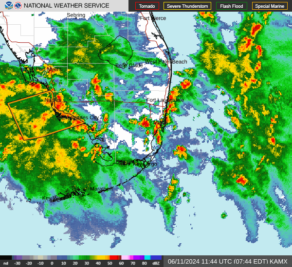
Chances of thunderstorms will increase across the region on Friday into Friday night. Some of the thunderstorms may be strong to severe and contain damaging wind gusts, according to the National Weather Service, Miami. Forecasters estimate 3 to 5 inches of rain are possible, with higher localized amounts possible.
South Florida weather: Cold front brings flooding rains, damaging winds to South Florida through Saturday
A couple of tornadoes are also possible. Heavy rainfall from showers and thunderstorms is possible on Friday into Friday night which may lead to some localized flooding, especially in poor drainage locations.
Weekend forecast
Friday: A chance of showers and thunderstorms, then showers likely and possibly a thunderstorm after 11 a.m. Mostly cloudy, with a high near 78. Windy, with a southeast wind 25 to 29 mph, with gusts as high as 33 mph. Chance of precipitation is 70%. New rainfall amounts between a half and three quarters of an inch possible.
Saturday: Showers and possibly a thunderstorm before 2 p.m., then a chance of showers and thunderstorms after 2 p.m. High near 77. Windy, with a south wind 21 to 24 mph, with gusts as high as 29 mph. Chance of precipitation is 80%.
Sunday: Mostly sunny, with a high near 75. Windy, with a northwest wind 21 to 24 mph.
Follow the National Weather Service Miami on X, formerly known as Twitter
Weather radar and forecast for Naples
Chances of thunderstorms will increase across the region on Friday into Friday night. Some of the thunderstorms may be strong to severe and contain damaging wind gusts, according to the National Weather Service, Miami. Forecasters estimate 3 to 5 inches of rain are possible, with higher localized amounts possible.
SWFL weather forecast: Rain, wind, rip currents, maybe even tornadoes, on their way to SWFL
A couple of tornadoes are also possible. Heavy rainfall from showers and thunderstorms is possible on Friday into Friday night which may lead to some localized flooding, especially in poor drainage locations.
Weekend forecast
Friday: A slight chance of showers and thunderstorms before 4 a.m., then a chance of showers and thunderstorms after 5 a.m. Mostly cloudy, with a low around 68. Southeast wind 8 to 13 mph, with gusts as high as 20 mph. Chance of precipitation is 30%.
Saturday: Showers likely and possibly a thunderstorm before 2 p.m., then a slight chance of showers. Partly sunny, with a high near 79. Breezy, with a west wind 15 to 17 mph, with gusts as high as 28 mph. Chance of precipitation is 60%.
Sunday: Sunny, with a high near 79. North wind around 15 mph, with gusts as high as 23 mph.
Follow the National Weather Service Miami on X, formerly known as Twitter
Weather radar and forecast for Fort Myers
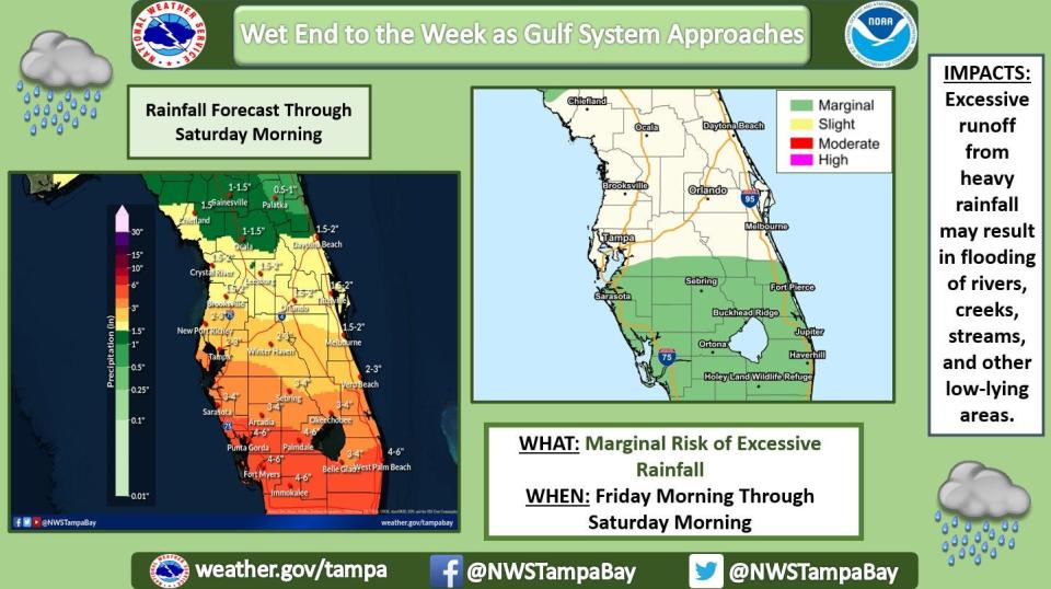
Numerous to widespread showers and thunderstorms are in the forecast, with rain totals of 2.5-5 inches expected between late Thursday and Saturday morning, mainly along and south of Interstate 4, according to the National Weather Service, Tampa Bay.
Strong to severe thunderstorms are possible Friday and Friday night, with damaging wind gusts, isolated tornadoes, localized flooding being the main threats, although isolated hail also will be possible.
Weekend forecast
Friday: Showers and possibly a thunderstorm. High near 76. Breezy, with an east southeast wind 13 to 18 mph, with gusts as high as 26 mph. Chance of precipitation is 90%. New rainfall amounts between 1 and 2 inches possible.
Saturday: A 50 percent chance of showers and thunderstorms before 2 p.m. Partly sunny, with a high near 79. Breezy, with a west wind 13 to 17 mph, with gusts as high as 26 mph.
Sunday: Sunny, with a high near 78. Breezy, with a north wind 14 to 16 mph, with gusts as high as 24 mph
Follow the National Weather Service Tampa Bay on X, formerly known as Twitter
Weather radar and forecast for Sarasota
Numerous to widespread showers and thunderstorms are in the forecast, with rain totals of 2.5-5 inches expected between late Thursday and Saturday morning, mainly along and south of Interstate 4, according to the National Weather Service, Tampa Bay.
Strong to severe thunderstorms are possible Friday and Friday night, with damaging wind gusts, isolated tornadoes, localized flooding being the main threats, although isolated hail also will be possible.
Weekend forecast
Friday: Showers and possibly a thunderstorm. High near 77. Windy, with an east southeast wind 18 to 21 mph, with gusts as high as 30 mph. Chance of precipitation is 100%. New rainfall amounts between a half and three quarters of an inch possible.
Saturday: Showers likely and possibly a thunderstorm before 8 a.m., then a slight chance of showers and thunderstorms between 8 a.m. and 2 p.m. Mostly sunny, with a high near 80. Breezy, with a west wind 13 to 18 mph, with gusts as high as 26 mph. Chance of precipitation is 60%.
Sunday: Mostly sunny, with a high near 80. Breezy, with a north wind 15 to 18 mph, with gusts as high as 26 mph.
Follow the National Weather Service Tampa Bay on X, formerly known as Twitter
This article originally appeared on Treasure Coast Newspapers: Florida weather forecast: Severe weather expected Friday, Saturday

