Thunderstorm risk lingers over Ontario, Quebec, as wildfire smoke spreads in
The risk for severe thunderstorms kicked off the week in parts of Ontario, with reports of heavy rain, strong winds and hail reported through the late afternoon and evening hours.
That risk for storms will continue into Tuesday, sluggishly drifting in a southerly direction as the day progresses. The storm threat is widespread, stretching into Quebec, as well, with the chance for stronger thunderstorms to bubble up in Saguenay and extreme southeastern sections of the province.
DON'T MISS: Canada's May long weekend has it all, except for the 'perfect' forecast
To compound the unsettled conditions will be wildfire smoke spreading in from Western Canada, with hazy skies and deeper sunrises and sunsets likely in the next few days.
Tuesday: Threat for thunderstorms spreads east into Quebec
After starting out Monday on an unsettled and stormy note, rain showers and thunderstorms will continue into Tuesday as a boundary stalls from Lake Huron to Ottawa and Quebec.
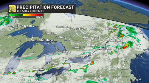
During the afternoon hours, stronger pop-up storms near London and Hamilton are possible, which could produce small hail.
Storms are expected to move in one after another, leading to heavy rain in a narrow band of the region.
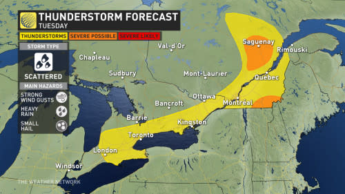
There are pockets of higher thunderstorm energy near Saguenay and extreme southeastern Quebec that could produce stronger thunderstorms, though some uncertainty remains in the computer models.
With the potential for multiple rounds of storms, residents are advised to remain vigilant and prepared for changing weather conditions. With storms that do develop, heavy rain, strong winds and small hail will be the main threats.
CANADA'S WILDFIRES: Visit The Weather Network's wildfire hub to keep up with the latest on the active start to wildfire season across Canada.
Adding to the atmospheric drama is the resurgence of wildfires across Western Canada. Smoke from these fires is spiralling into a trough that extends across Ontario and Quebec, reaching the region on Tuesday.
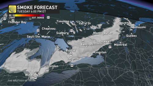
While most of the smoke will remain aloft, some will filter down impacting air quality in southern Ontario on Tuesday. Look out for hazy skies and deeper sunrises and sunsets in the next few days.
Wildfire smoke can be harmful to everyone’s health, even at low concentrations.
Wet weather kicks off the May long weekend
Looking ahead, more wet weather will kick off the May long weekend, with rain and another chance for thunderstorms spanning the region on Friday.
The whole weekend will be far from a washout, however, as pleasant temperatures and drier conditions return. Most of the St. Lawrence will see daytime highs in the low 20s, as temperatures slowly climb across southern Ontario, as well.
We're even watching the potential for a taste of summer-like weather, with temperatures in the mid-to-upper 20s on Sunday if well-timed sunny periods align. There's a higher risk for showers and thunderstorms developing for Monday, and then trending somewhat cooler for the middle and end of next week.
Stay with The Weather Network for all the latest on your forecast across Ontario.

