Thousands of cultural heritage sites along the Georgia coast are threatened by storm surge
A new message from a social scientist: storm surge from strong hurricanes is the real threat to cultural heritage and significant historic sites.
The threat of erosion and infrastructure damage from sea level rise is not a new issue for coastal cities. But just as significant are thousands of archeological heritage sites that tell the important story of people and history that make up Georgia’s past.
Matt Howland, an assistant professor of archaeology at Wichita State University, used a spatial modeling tool incorporating data from NASA and the National Weather Service, that revealed up to 4,892 cultural heritage sites along the Georgia barrier islands and coastal plains could be inundated from storm surge during hurricane events by the year 2100.
This is compounded by sea level rise from climate change. A previous study in 2017 indicated some 397 sites would be inundated, a near 10-fold increase.
At present, a tropical storm would currently threaten 953 sites.
By 2100 it could be 1,898 sites from sea level rise combined with the forces of a storm, according to Howland’s study. But if a Category 5 hurricane comes tomorrow, the number quadruples.
“If a Cat 5 comes and hits coastal Georgia tomorrow 4,290 sites are at risk,” Howland said.

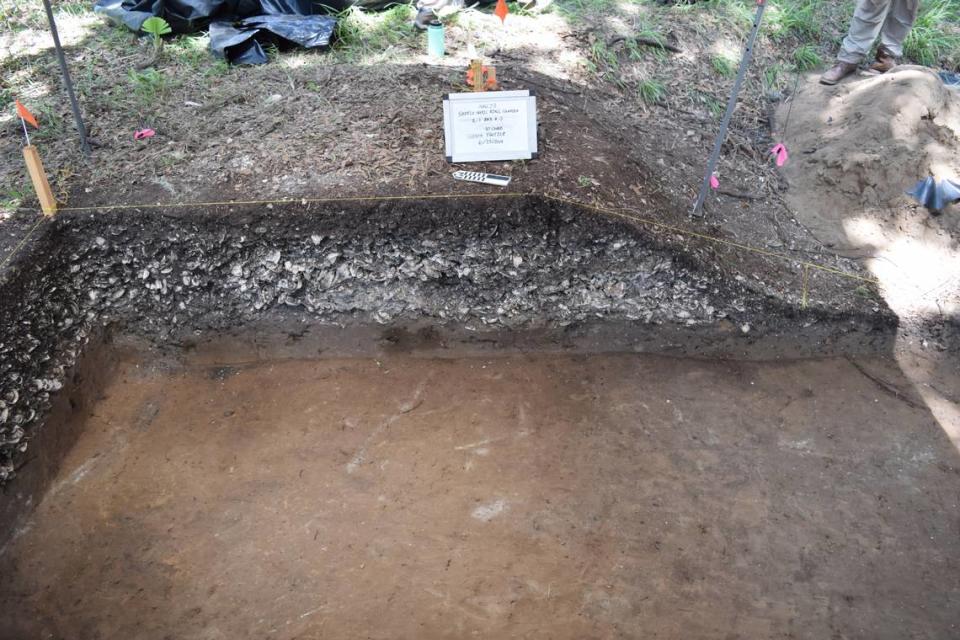
The Georgia coast and the inland plains host a diverse and abundant trove of cultural and historic sites that paint a picture of the state’s unique history. From English and Spanish Forts dating back to the 18th and 19th centuries to plantations with enslaved African Americans to Indigenous Muscogee sherds (scattered pieces of pottery) and oyster harvesting sites that date back 5,000 years, Georgians have access to sites that tell an important story of how things were and came to be.
“Cultural heritage sites have a big impact on how we interpret our own past,” Howland said. “There’s not really a comprehensive effort at the scale needed to protect these sites from the impact of climate change.”
“This is potentially catastrophic for both living communities along the Georgia coast and the archaeological record,” Howland wrote in his paper.
Sea level rise is a slow burn. It’s coming. But the erosion from storm surge is the threat, said Leslie Reeder-Myers, an associate professor of anthropology at Temple University.
“Sea level rise isn’t a new phenomenon,” Reeder-Myers said. “Storms have always wiped out archeological sites. Now it’s accelerating. This isn’t about making sure it doesn’t erode. It’s about making sure we are preserving memory and heritage which is incredibly important to our culture.”
Who decides what and how sites are preserved?
Management and preservation aren’t necessarily in the job description of an archeologist. It’s the job of whoever owns the land, like the National Park Service or the Nature Conservancy. It can also be private land owners, Indigenous preservation officers, or state preservation officers.
“Preservation is something archeologists have been grappling with in our whole profession,” Reeder-Myers said. “We spend a lot of time identifying problems but we haven’t decided on what we want to preserve. Preservation isn’t in our purview or expectations. You don’t get an award for preserving a site.”
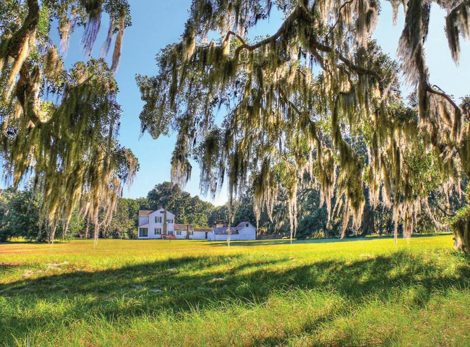
The Hofwyl-Broadfield Plantation in Gylnn County, just north of Brunswick has an evacuation plan, but no preservation plan. The rice plantation operated as a forced labor farm, using enslaved people until 1865. About 10-15 thousand tourists per year “mostly passing through,” stop by, Bill Giles, the historic site manager said.
“During hurricane Matthew in 2016 we had to close for two weeks because so many tree limbs fell, it was unsafe to be open,” Giles said. “But we’re about 20 feet up on a hill away from the marsh.”
Hurricane Matthew was a Category 3 hurricane that caused major damage in the Carolinas.
Howland’s projections suggest under a high (3.0 meter of sea level rise) scenario by the year 2100 Hofwyl-Broadfield could be inundated by a Category 3 hurricane.
The Hofwyl-Broadfield Plantation, Wormslow Historic Plantation, and Fort King George are all part of the state park system, and are known and accessible to the public. Fort Frederica, another notable site that would be inundated, is part of the National Park Service. Most of the 4,000 or so sites are inaccessible because they are on private land or culturally significant and protected by the state.
The Historic Preservation Division within the Georgia Department of Community Affairs focused on carrying out federal and state preservation programs.
Justin Vining, communications manager for the Historic Preservation Division, said in an email he “cannot provide detailed information” on Georgia’s preservation techniques.
“Our statewide plan outlines general strategies, but addressing the specific concerns related to storm impact on cultural sites requires on-the-ground expertise, which is beyond our scope.”
Howland has shared his SPLOSH model results with the Georgia Historic Preservation Division but isn’t sure if they have done anything with the results.
Turner Hunt is the Muscogee preservation officer, based in Ocmulgee, Oklahoma, still connected with thousands of years of history, but doesn’t necessarily decide what gets preserved.
“Oyster shell mounds on Sapelo Island were our first reservations,” Hunt said. Adding, “They are part of our origin stories.”
The reservations were created in the 1729 treaty of Coweta and 1757 treaty of Savannah.
Because of these treaties, Hunt said, these areas should be consulted with the Muscogee (Creek) nation by archeologists. But, there isn’t much Hunt can do.
The barrier islands are part of the origin and migration story of the Muscogee Creek.
“They are most incredibly important and most at risk and some of the oldest man-made structures in North America,” Hunt said.
The no-plan plan
It’s unclear who takes care of the mounds or monitors during storms.
“We don’t have much activity in the proactive realm,” Hunt said. “People aren’t taking care of it beforehand, it’s a reaction to disaster.”
Hunt will likely receive a call from FEMA, asking how much federal money they want to go into these sites, a week or so after a storm hits.
Sometimes the opposite happens. After Hurricane Michael, Hunt called and checked on cultural sites in Southern Georgia.
Reed Meyers said archeologists struggle with their role of digging, preserving, Do we need to keep digging? Are there enough museum collections? Is it ethical to keep digging?
Some sites are supposed to return to the earth.
“When a Muscogee person passes away, a grave house is constructed within four days,” he said. “The debate now is whether these are natural or manmade, and whether we need to take action to prevent any of this.”
Turner worries that some of these significant pieces of history that belong to Muscogee will just end up in museums.
“Archeologists come to dig up items, save it, and take a cultural site and into a scientific commodity,” he said.
Reed-Meyers said there is no way a handful of archeologists or people at the state can preserve all 4,000 sites.
“There are very few resources for preservation, funding for archeologists, there are maybe a handful for the state and they have a lot of other jobs to do,” Reed Meyers said.
Kait Morano is the resilience planning director for Coastal Equity and Resiliency Hub (CEAR) in Savannah. She’s disappointed in the lack of work done by the city despite more awareness on the part of scientists to communicate what it means.
“Effingham, one county inland from Chatahm, may not see the sea level rise impact but they will see storm surge,” she said.
Right now, there is no resilience plan for Savannah, only Tybee Island has a sea level rise plan.
“Tybee’s is a good plan that focuses on natural infrastructure,” Morano said. “Chatham County only just created a resilience plan.”
Sea level rise really means more flood events per year, Morano said.

