Tallest wave ever recorded could have swamped the White House

Located at the intersection of prevailing storm tracks and colliding ocean currents, the North Atlantic Ocean is home to some of the largest waves in the world. The region can now lay claim to a world record wave, after the World Meteorological Organization this week certified a record wave height of 19 meters, or 62.3 feet recorded in 2013.
The wave was measured by a UK Met Office buoy floating between Iceland and the United Kingdom on Feb. 4, 2013. The wave occurred after a cold front passed across the area, bringing winds of 50 miles per hour to that location.
This wave beat the previous record-holder of 59.96 feet, which was also set in the North Atlantic, back in 2007.
SEE ALSO: Dramatic NatGeo photos show how climate change is transforming the world
According to the WMO commission for climatology’s extremes evaluation committee, the monstrous wave is “the highest significant wave height as measured by a buoy."
“This is the first time we have ever measured a wave of 19 meters. It is a remarkable record,” said WMO assistant secretary-general Wenjian Zhang, in a press release.
“It highlights the importance of meteorological and ocean observations and forecasts to ensure the safety of the global maritime industry and to protect the lives of crew and passengers on busy shipping lanes,” he said.
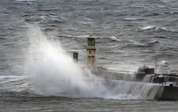
Image: Gareth Fuller/PA via AP
There is a separate record, which was also set in the North Atlantic between the UK and Iceland, for the highest significant wave height as measured by ship observation. That occurred in 2000.
Wave height, and "significant wave height," are more complicated metrics than they might first seem.
According to the WMO, "wave height is defined as the distance from the crest of one wave to the trough of the next." But the term, "significant wave height," means "the average of the highest one-third of waves measured by an instrument, and is comparable to what an observer would see as an average of about 15-20 well-formed waves over a period of about 10 minutes."
This means that a significant wave height of 62.3 feet implies that there may have been individual waves during that period that were significantly higher than that.
rapid cyclogenesis of hurricane force low over the Atlantic, via GeoColor satellite imagery - next major low organizing over the Gulf Stream pic.twitter.com/XpnUqR5S3H
— NWS OPC (@NWSOPC) December 14, 2016
Fall and winter storms in the North Atlantic can intensify rapidly, undergoing a process known as "bombogenesis," in which the atmospheric pressure inside the storm plunges rapidly. This can induce sudden increases in wind speeds for hundreds, if not more than 1,000 miles, in diameter.
dangerous, active low track to persist across the Atlantic next 7 days - WaveWatch III outputs several rounds of phenomenal seas (>14m/45ft) pic.twitter.com/OZR7Mho060
— NWS OPC (@NWSOPC) December 13, 2016
The WMO said the area from the Grand Banks off the coast of Newfoundland to the south of Iceland, then southeastward to the west coast of the UK, including the Rockall Trough, "are prime candidates for wave records."
The WMO, which is a United Nations agency, is responsible for certifying world weather records. Earlier in 2016, a WMO committee certified the longest reported distance and the longest-lasting lightning bolts, the latter of which was in the south of France.
While the record wave was measured in 2013, the WMO often takes years to certify official records to be sure that the recording equipment in question — in this case, a buoy — was working properly, and that experts were not missing any other wave that was actually bigger than the one recorded.
