What’s a supercell thunderstorm and the science behind the ‘historic’ Broward flood?
Meteorologists are calling Wednesday’s near 26 inches of rain in Fort Lauderdale a “1-in-1,000-year” event.
The Weather Channel blamed a “stalled supercell thunderstorm“ for the deluge that shut down schools and a major international airport, and put surrounding neighborhoods underwater.
Good afternoon!
Thunderstorms will develop this afternoon across SFL, bringing a risk of both severe weather and flooding.
Please exercise caution, particularly in those areas saturated from prior rainfall and/or where residual flooding is ongoing!#Flwx pic.twitter.com/GLFSOEf1mh— NWS Miami (@NWSMiami) April 13, 2023
Here’s what to know about what was behind the weather:
Why did South Florida get all this rain?
There were areas of South Florida that received prolific rainfall amounts yesterday, with the highest amounts of over 20 inches in coastal Broward County. Here is a map of the preliminary rainfall reports for 24 hours ending this morning.#flwx https://t.co/Ttl2lmxCOU pic.twitter.com/5LIPDVedqr
— NWS Miami (@NWSMiami) April 13, 2023
There is a weather science behind the five-day rain streak that began Easter Sunday, weather experts say.
National Weather Service in Miami meteorologist Sammy Hadi predicted the weather pattern that has given us such a wet week.
“There’s a frontal boundary in the Florida Straits,” he told the Miami Herald early on the start of the second nearly full day of rain. “It’s basically along the Florida Keys. And basically what’s resulted is today [Tuesday] the bulk of the heavy rainfall will stay largely confined to the Florida Keys, the Florida Straits and Miami-Dade County.”
Then Wednesday came, with the shifting of winds and a mightier frontal boundary.
“The issue is as this frontal boundary begins to lift further north, this warm front begins to push further north across the area beginning [Tuesday night] into Wednesday. And during the day on Thursday, there will be the potential for all this heavy rain to work back up northwards across the area. And in doing so, there’s the potential for thunderstorms as well,” Hadi said.
This is why a significant rain chance in South Florida remained on Thursday afternoon and flood warnings into the evening.
Luke Culver, a storm data specialist for the weather service picked up on Hadi’s explanation in a phone interview with the Miami Herald on Thursday. Hadi’s prediction had come to pass.
“We just had a warm front slowly moving across the area yesterday, which led to slow moving and kind of back filling heavy rainfall showers and thunderstorms,” Culver said.
In other words, a succession of storms, all unloading in fast succession, steered by a cross section of winds and a particularly high amount of atmospheric moisture stirred off Atlantic waters, fellow NWS meteorologist Shawn Bhatti told the South Florida Sun-Sentinel on Thursday.
“The best way to explain it is that winds steer storms and moisture. In the lower 1-3 kilometers [of the atmosphere] we had east-southeast flow with really good moisture coming off the Atlantic water. Then we had good southerly flow in the mid levels, and above that we had westerly wind,” Bhatti told the Sun-Sentinel.
Now add another factor that came into play: a supercell thunderstorm.
What’s a supercell thunderstorm?
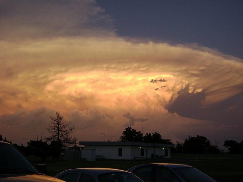
According to the weather service, a supercell thunderstorm is a tall storm cloud that has an anvil that stretches far east.
“What makes a supercell unique from all other thunderstorm types is that it contains a deep and persistent rotating updraft called a mesocyclone,” the weather service said on its website. Wind sheer creates the mesocyclone and allows the storm to be tilted, which maintains its separate updraft and downdraft regions. These characteristics give supercells their hours-long longevity — and helps explain why so much rain soaked Fort Lauderdale-area neighborhoods Wednesday.
Supercells are the least common type of thunderstorm but earn their name for their high propensity to produce severe weather that can spawn tornadoes.
“Those are not totally atypical for here, especially during the wet season. It just so happened that multiple rounds of those thunderstorms kept recurring over the same area and that was primarily the Fort Lauderdale metro area,” Culver said.
A storm for the millennium?
So, from a climatological perspective, did Wednesday’s rains in Fort Lauderdale feature as a 1-in-1,000-year occurence or a 1-in-500-year storm?
Both. Depends on the time being measured.
The local weather service used Fort Lauderdale-Hollywood International Airport as its location.
Nick Carr, lead forecaster with the National Weather Service’s Miami office, called the 25.91-inch rain totals “historic” and confirmed that this much rain in a single 24-hour day has a 0.2% chance of happening every year, which makes this a 1-in-500-year storm.
KNOW MORE: ‘Historic’ flooding in Fort Lauderdale
But that much rain fell in a fraction of that time, which also allows for meteorologists to call what happened Wednesday a 1-in-a-1,000-year event.
NWS Miami meteorologist Jennifer Simmons explained: “Relative to a six-hour time period — which is when a lot of this rain fell, within 6 to 12 hours — these rain amounts have a 1-in-1,000, which is . 1% chance, of occurring at FLL in any given year. So, you probably heard the 1-in-1,000 because they were looking at a short time period because so much of this rain did fall in such a short time period.”
What about the tornadoes?
Our survey crew has completed the tornado damage portion of their investigation. Two EF0 tornadoes were confirmed near Dania Beach yesterday. More info can be found in this Public Information Statement (PNS): https://t.co/lexa1IhU14… or in the attached graphic. pic.twitter.com/CG7HulO8e0
— NWS Miami (@NWSMiami) April 13, 2023
On Thursday, the weather service’s survey crews confirmed that two EF0 tornadoes touched down near Dania Beach Wednesday.
The first happened at 3:26 p.m. about a mile west of Hollywood and was of short duration causing minimal damage. “The tornado may have just impacted the tree-top level,” the survey team wrote in its report.
The second EF0 tornado happened at 9:41 p.m. about a mile west-southwest of Dania Beach. This short-lived tornado was a bit stronger and “caused tree damage along Old Griffin road before crossing into a mobile home community east of Interstate-95,” the weather team wrote. Metal siding roof damage was noted throughout the community, they wrote.
There were no reported injuries.
Miami Herald climate change reporter Alex Harris contributed to this report.

