Super Typhoon Meranti, the strongest storm on Earth this year, nears Taiwan
UPDATE: Sept. 14, 2016, 3:59 p.m. SGT Super Typhoon Meranti hits the southern tip of Taiwan, knocking out the power in over 260,000 homes and injuring two. 1,500 people were evacuated in anticipation of the Category 5 storm's arrival.
UPDATE: Sept. 13, 2016, 5:46 p.m. EDT The Joint Typhoon Warning Center raised its intensity estimate of Super Typhoon Meranti on Tuesday afternoon, eastern time. According to JTWC, the storm had sustained winds of 190 miles per hour, with gusts to 230 miles per hour. It is now forecast to make landfall in China as a Category 3 typhoon on Sept. 14.
UPDATE: Sept. 13, 2016, 3:59 p.m. EDT Super Typhoon Meranti made landfall on tiny Itbayat Island, which is owned by the Philippines and is reportedly home to around 2,800 people.
The entire island fit within the fierce storm's eye, creating a rarely seen satellite view early Wednesday morning, local time. The storm is wobbling on a path that will take it off the southern coast of Taiwan on Wednesday morning (Tuesday evening EDT), before heading toward a landfall in China.
Itbayat in the eye of extreme typhoon #Meranti #FerdiePH pic.twitter.com/jciYD9wS9k
— Stu Ostro (@StuOstro) September 13, 2016
Super Typhoon Meranti reached an extraordinary peak intensity on Tuesday morning eastern time, becoming the strongest storm recorded anywhere on the planet this year, with estimated maximum sustained winds of 185 miles per hour.
It is also the strongest storm in the Western Pacific since Super Typhoon Haiyan, which devastated the Philippines in 2013.
Wind gusts in the storm's most intense inner core are estimated to be above 220 miles per hour, which would be capable of stripping trees of their leaves and producing catastrophic damage on most human-made structures.
SEE ALSO: Category 5 Super Typhoon Meranti is strongest storm of 2016 season
Super Typhoon Meranti beat out Super Typhoon Nepartak, which had 180-mile-per-hour winds, and Cyclone Winston, which also peaked at 180 miles per hour, to become the strongest storm of 2016 so far.
Remarkably, the storm has had 185-mile-per-hour winds or greater for at least 18 hours, a feat only accomplished by two other super typhoons in that ocean basin since 1970, according to storm researcher Philip Klotzbach of Colorado State University.
Meranti poses a serious threat to southwestern Taiwan, particularly the 2 million residents of Kaohsiung City, which is the second most populous city on the island. While the eye may stay just off the coast by about 50 miles, extremely strong hurricane force winds will lash the coastline during its closest pass at around 8 a.m. local time on Wednesday.

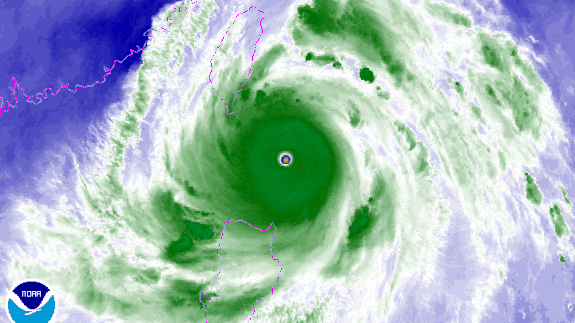
Image: NOAA
#VIIRS VIS to IR fade (375-m resolution) of Super Typhoon #Meranti at 0508 UTC today pic.twitter.com/VZxWcaGphU
— Dan Lindsey (@DanLindsey77) September 13, 2016
Heavy rains, strong winds and coastal flooding can be expected on Wednesday, local time, particularly along Taiwan's east and south facing coastlines. Heavy rains from the storm are also hitting in the northern Philippines.
Super Typhoon Meranti is the fourth Category 5 storm on the planet in 2016. On average Earth sees between 4 and 5 Category 5 storms per year.
Fortunately, there are reasons to believe the storm will not affect Taiwan at its current intensity.
Like human sprinters that are poor distance runners, storms that attain such high levels of intensity can run into trouble maintaining their peak performance for too long, with internal processes coming into play that can temporarily slow the storm's winds and raise their minimum central air pressure.
Such dynamics, known as an eyewall replacement cycle, may help the storm temporarily weaken as it makes its closest pass to the south of Taiwan or across the southern tip of the island.
When that dark red ring is that intense in this microwave channel 😳 rare signature for a powerful #Typhoon #Meranti pic.twitter.com/FYTiabS1a7
— Eric Blake (@EricBlake12) September 13, 2016
These cycles involve the decay of the inner ring of thunderstorms surrounding the storm's eye before being replaced by another eyewall that starts from further outside the eye and works its way in.
That process can take at least 12 hours, and can weaken a storm by an entire category or more before it can restrengthen.
The forecast calls for this storm to weaken to the equivalent of a Category 1 or 2 storm before hitting the Chinese coast early on Thursday, local time.
This weakening trend is forecast to occur, in part, because of the storm's interaction with Taiwan's mountains and passage over slightly cooler waters as it nears China. However, storm intensity forecast errors are larger than for track forecasts.
The most likely landfall region in China appears to be between Shantou and the port city of Xiamen.
The storm is at its peak intensity in a part of the world that is one of the most reliable breeding grounds for powerful typhoons. A recent study found that the most intense storms in this region may be intensifying due in part to global warming, particularly due to warming ocean temperatures.
