Sunshine returns just in time for Valentine’s Day
Tonight features partly cloudy skies with temperatures dropping back into the mid 20s. It’s a much quieter night on the way in comparison to what we experienced last night!

Valentine’s Day brings high pressure briefly back in control, which means our weather will be quiet. High temperatures will be chilly in comparison to where we’ve been but the reality is that we will be close to typical for this time of year with highs in the mid 40s.

If you plan to take your love out to dinner, we are looking great weather-wise, but don’t forget the jackets – temperatures will be in the upper 30s around dusk and drop down through the 30s during the evening.

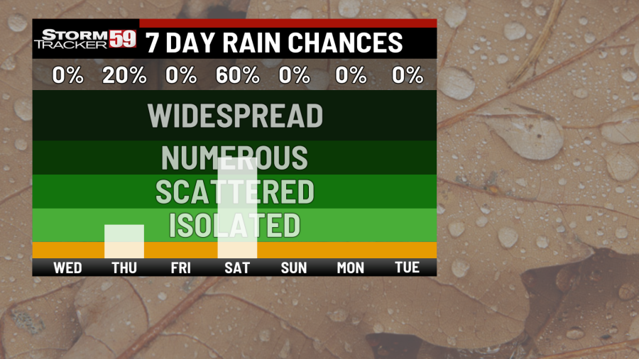
Thursday brings our next system into the region – a weak clipper system. They are notorious for moving through an area quickly and this one will not be an exception, with a few rain showers during the day and perhaps a flurry or two across the high country during the overnight with a northwest flow kicking in behind the system. High temperatures during the day will be mild in the mid 50s.
All the things you need to make Valentine’s Day treats
Friday is dry with our clipper system gone – we’ll see the sunshine return with partly sunny skies and high temperatures in the mid 40s. Clouds will be on the increase late in the day as our next system approaches with a shower or two after dusk.

Saturday provides a return of snow showers to the region with an area of low pressure scooting through. That low pressure system will be directly overhead before dawn Saturday, meaning we’ll see rain showers initially. However, as colder air seeps in on the back side of that system, we’ll see rain switch over to a few snow showers. It’s not much snow but it’s a reminder that Old Man Winter is still here! High temperatures will be in the mid to upper 30s.
Sunday brings the sunshine back into the area with high pressure in control. This will be the first of a few dry days on the way with high temperatures around 40 degrees.

Presidents’ Day looks solid! High pressure will continue to keep the clouds and showers at bay with mostly sunny conditions expected and temperatures rebounding to near 50 for highs.
Tuesday continues our sunny skies with mostly sunny conditions and highs in the low 50s.

Looking ahead, we are back into a cooler stretch of weather ahead this week. Next week looks a bit warmer with highs returning to the 50s but beyond that, temperatures generally at or below normal for the end of February. Our pattern looks a bit more active than we’ve seen recently – snow chances will be dependent on exact low-pressure tracks to get enough cold air in for precipitation to fall as snow but at this point, accumulating snows ahead look minor for the remainder of this month. Help us with our growing community of weather photos with #weathertogether. Head to our website and search for the ‘Weather together’ tab and upload your photos of weather going on around our region.
Help us grow our online weather photo gallery by uploading your photos here

TONIGHT
Partly cloudy. Chilly! Lows in the mid 20s.
VALENTINE’S DAY
Partly sunny. Highs in the low 40s.
THURSDAY
Few rain showers, mainly in the afternoon. Highs in the mid 50s.
FRIDAY
Partly sunny, increasing clouds late. Highs in the mid 40s.
SATURDAY
Rain and snow showers likely. Highs in the mid to upper 30s.
SUNDAY
Partly sunny. Highs near 40.
PRESIDENTS’ DAY
Mostly sunny. Highs near 50.
TUESDAY
Mostly sunny. Highs in the low 50s.
WEDNESDAY
Few showers. Highs in the 50s.
THURSDAY
Few showers. Highs in the 50s.
FRIDAY
Shower chances continue. Highs in the 50s.
For the latest news, weather, sports, and streaming video, head to WVNS.

