Florida to be battered by strong winds in the wake of Thursday's violent storms
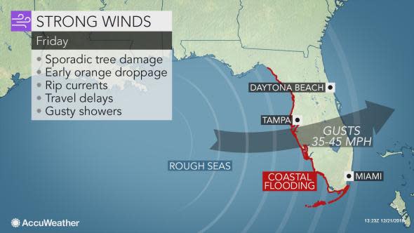
In the wake of severe thunderstorms that damaged dozens of homes in Florida on Thursday, gusty winds on Friday will threaten to cause even more damage across the state.
The storm system that spawned the destructive winds and even produced a few tornadoes in the state on Thursday has since moved into the Appalachians, but gusty westerly winds are in store in its wake on Friday.
"Due to the onshore wind direction, coastal flooding will be possible from the central panhandle down the west coast of the peninsula and into the Keys," AccuWeather Meteorologist Ryan Adamson said.
As of Friday morning, tides were more than 3 feet above normal at Tampa, Florida.
The full moon is on Saturday, and the days leading up to the full moon result in progressively higher astronomical tides.
Those living along the Florida Peninsula's west coast should move to higher ground if floodwaters threaten, and holiday travelers should seek an alternate route if water is covering the roadway ahead.
It is impossible to determine how much water is covering a road using the naked eye alone, and it only takes 1 foot of water to float most vehicles.
Adamson added that the strong winds will create an enhanced risk for rip currents and lead to unusually large waves and rough surf.
Anybody heading to the beach and planning to swim in the Gulf of Mexico should do so near a lifeguard or simply make alternate plans.
In addition, localized beach erosion is possible, and people should make sure to obey swimming and flooding advisories when and where they are issued.
"The strong winds, combined with the wet ground from Thursday's rain, may also lead to sporadic downed trees, which may fall onto power lines and lead to isolated outages," said Adamson.
#Skyway - Wind Speeds have accelerated to 57 MPH and gusting to 64 MPH. The Skyway Bridge is now CLOSED to all traffic. pic.twitter.com/x5KTEnOxIZ
— FHP Tampa (@FHPTampa) December 21, 2018
Widespread wind gusts of 35-45 mph are likely across the state on Friday, and winds of this strength can easily blow away garbage cans or loose, outdoor furniture.
Download the free AccuWeather app to find out how strong wind gusts will be in your community.
Cleanup efforts in the aftermath of Thursday's storms will also be hindered on Friday and may, in some cases, have to be put off until the weekend.
Motorists traveling on Interstates 4, 75 and 95 will face dangerous crosswinds that can make driving extremely difficult.
Reducing speed and keeping a firm grip on the steering wheel can help reduce the risk for spinouts and traffic accidents in these blustery conditions.
"The orange groves will also be affected by these winds, and this could cause some of the oranges to drop off the trees early," Adamson warned.
Depending on the extent of the drop, this could cause orange prices to rise across parts of the United States later in the winter.
The winds will accompany high temperatures only in the lower to middle 60s F in Orlando, Tampa and Jacksonville and in the lower 70s F in Miami.
AccuWeather RealFeel® Temperatures will be stuck in the 50s across central and northern portions of the state and in the 60s across southern parts of the peninsula, so residents may want to grab a jacket or sweatshirt before heading outdoors.
High pressure will quickly build back into the state on Friday night and Saturday, allowing the gusty winds to subside rapidly after sunset.
