Strong wind gusts tonight, downed trees and outages possible
Alerts Issued for Our Region
WIND ADVISORY is in effect from 7 PM Monday to 1 PM Tuesday for Raleigh, Wyoming, Fayette, Nicholas, Tazewell, Mercer, Summers, western Greenbrier and northwestern Pocahontas counties in our region. A southeast wind of 20 to 30 mph with gusts up to 50 mph will blow around unsecured objected. Power outages are a possibility with the potential for downed trees and limbs.

Tonight will feature windy conditions with a southeast breeze picking up in intensity. Sustained wind of 15 to 25 mph with strong wind gusts as high as 40 mph are expected tonight with a strong ridge east of us and a strong southern low to the west. This difference in pressure will create the potential for strong wind gusts through the first half of Tuesday. Otherwise, we’re looking at partly cloudy skies with low temperatures in the mid to upper 30s. With the strong wind gusts in place and low humidity values, please do not burn tonight.

Tuesday brings increasing clouds and showers increasing in coverage from west to east as a warm front, followed eventually by a cold front, pushes through the region. Strong wind gusts are a good bet, with gusts as high as 50 mph possible through the early afternoon, which could cause a few power outages. It’s a mild day out ahead of the cold front with a strong southerly breeze pushing temperatures once again up into the mid to upper 50s. Showers will be steadiest during the late afternoon and into the evening hours, so expect wet roads for the evening commute. Showers will continue overnight and into the start of our Wednesday with lows in the 40s. Expect a quarter to a half inch of rain for most from Tuesday’s rain – flooding is not expected.

Wednesday keeps showers around for the morning, which will linger into the afternoon for the mountains as our cold front scoots through the region. Very warm air out ahead of that front will enable temperatures to jump up into the 60s for highs – enjoy it because we will cool back down behind the front. With a low pressure system riding up the east coast, clouds will remain thick Wednesday night, especially the farther east you are, with a few sprinkles still possible in our eastern counties. With clouds around, it’s not an overly cold night, with lows in the mid to upper 30s.
Thursday keeps pesky clouds around, again especially the farther east you are with the aforementioned east coast low pressure system nearby. Clouds will diminish in coverage the farther west you are, so it’s a bit of a split forecast. It’s a colder day for everyone with high temperatures in the low 50s. With mostly clear skies expected overnight, temperatures will fall back into the low 30s and upper 20s.
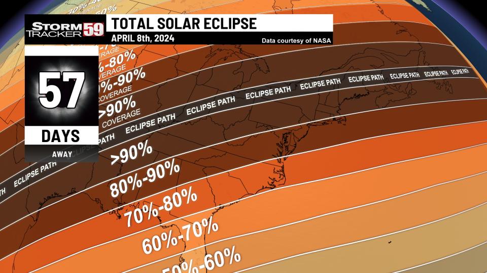
These are the glasses everyone is buying to prepare for April’s total solar eclipse
Good Friday will be a beauty of a day with high pressure in control to our west and temperatures warming back up into the mid 50s. It will be a breezy day, adding a little bite to the warmer temperatures.

Saturday brings the risk for a few showers, but at this point, there should be plenty of dry time, as a warm front scoots through. We’ll see temperatures jump nicely as a result of the southerly breeze behind that warm front, with highs jumping into the 60s.
What should you do if you are bitten by a tick?
Easter Sunday looks to remain mild but the chances for showers will be around with a cold front passing as an area of low pressure looks to scoot through the Ohio River Valley. Although it doesn’t look like a washout at this point, the chances for showers will try to put a damper on the bunny’s visit. Despite the showers, it’s a warm day in store with highs in the 60s.

Monday will look to begin on a soggy note with another system pushing through the region. That will keep the chances for showers around with highs in the 60s.
Looking ahead, temperatures will return closer to normal for this time of year Tuesday, Wednesday and Thursday as high temperatures drop into the 50s. An unsettled pattern will persist heading through midweek, which will keep the umbrellas handy as an accessory.

Help us with our growing community of weather photos with #weathertogether. Head to our website and search for the ‘Weather together’ tab and upload your photos of weather going on around our region.

We are in spring forest fire season in West Virginia – this means don’t burn between 7 AM and 5 PM through May 31st. Low humidity values during the daytime, along with breezier and warmer conditions will at times increase the fire threat, hence the burn ban during most of the daytime. Follow all regulations or be faced with potential consequences, such as fines! In Virginia, the spring fire season continues through April 30th – don’t burn before 4 PM.

TONIGHT
Partly cloudy. Breezy. Lows in the upper 30s. Wind gusts up to 40 mph expected.
TUESDAY
Showers likely, especially during the afternoon. Strong wind gusts during the morning up to 50 mph. Highs in the mid to upper 50s.
WEDNESDAY
A few morning showers, especially east. Warm! Highs in the mid 60s.
THURSDAY
Partly sunny with an isolated sprinkle. Cooler. Highs in the low 50s.
GOOD FRIDAY
Sunny but breezy. Highs in the mid 50s.
SATURDAY
Few showers possible. Highs in the mid 60s.
EASTER SUNDAY
Few rain showers. Still mild. Highs in the low to mid 60s.
MONDAY
Shower chances persist in scattered form. Highs in the mid 60s.
TUESDAY
Showers likely. Highs in the 50s.
WEDNESDAY
More scattered shower. Highs in the 50s.
THURSDAY
Lingering sprinkles. Afternoon clearing. Highs near 50.
For the latest news, weather, sports, and streaming video, head to WVNS.

