Strong to severe storms possible for Memorial Day
6:00 PM Weather Outlook
5:45 PM Weather Outlook:
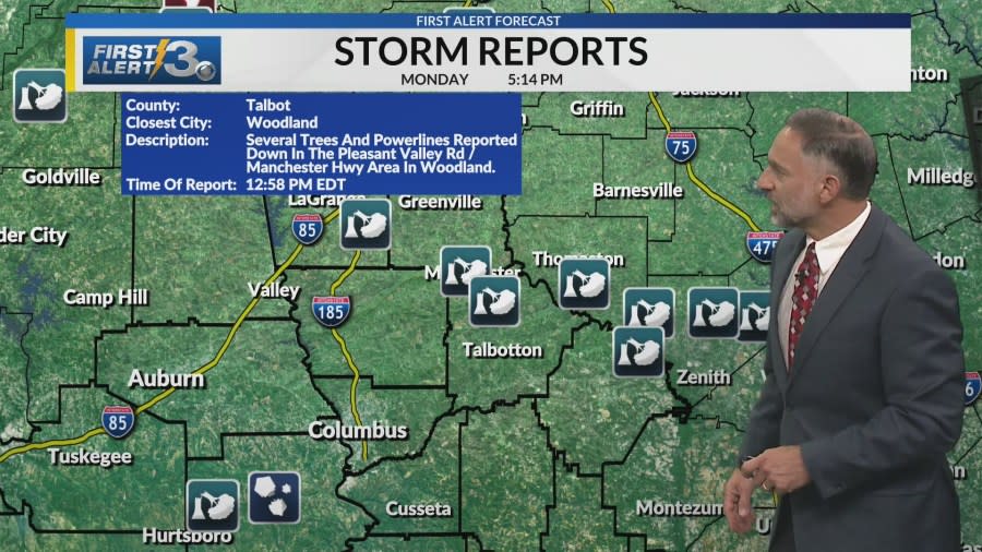
UPDATE 5/27/24 3:34 p.m.: This storm threat appears to continue all the way through about 10 PM Eastern time tonight, as it exits southeast of Columbus. In the overnight will be areas patchy fog.
We’ll start the day off with sunny conditions. We will see the region heat up rapidly, still ahead of high-pressure building back into the region so temperatures will easily hit 90 for most of us or a couple low 90s.
A few fair-weather clouds are going to be present through Wednesday, with plenty of sunshine. Later in the day, expect increasing clouds ahead of another front draping through the region on Thursday. Temperatures will be dropping down into the mid 80s because of increasing clouds. This is a weak front and most of the energy will remain north of the News 3 viewing area across Alabama and Georgia, however, as it says a bit south, we can expect to see late afternoon showers and a stray thunderstorm or two Thursday.
Friday through the weekend, there are still some short waves (disturbances that are weak) we need to watch, the main issue would be the exact track into our region. This would mean we may have to watch for some thunderstorms being added for Sunday. But at this time, we’ll keep readings in the mid to upper 80s and a mix of clouds and sun.
Columbus, Ga (WRBL)- Tracking a strong cold front that has brought severe weather from Texas through Tennessee. Your Memorial Day will unfortunately be spend dodging showers and storms.
Memorial Day Forecast: A Severe Thunderstorm Watch is now in effect for Chambers, Troup, Meriwether, Muscogee, Harris, Talbot, and Taylor. This will be through the early afternoon and could be extended if the line holds up.
Our primary threats remain damaging wind gusts up to 70mph, small hail, and heavy rain, however a brief tornado cannot be ruled out. There will likely be another round of storms this afternoon, depending on how much daytime heating we see.
Work Week: After this front passes through, temperatures will briefly reach into the 90s again Tuesday before dropping back into the mid 80s. There will be plenty of sunshine for the remainder of the workweek. Plus, conditions will remain breezy through Wednesday afternoon with winds gusting up to 20mph.
Weekend: Rain chances come back into the forecast by the weekend as another system brings multiple days for showers and storms starting Saturday.
Copyright 2024 Nexstar Media, Inc. All rights reserved. This material may not be published, broadcast, rewritten, or redistributed.
For the latest news, weather, sports, and streaming video, head to WRBL.

