Severe weather threat starts to diminish Friday for Sioux Falls
Update as of 6:45 p.m.: The threat for severe weather has begun to dampen. Showers will continue through the weekend, but they aren't expected to be severe, the NWS states.
The severe threat has begun to decrease. Expect showers & T-storms to continue through early SAT morning. These are not expected to be severe, but could still produce hail up to nickels, & wind gusts of 50mph. Locally heavy rainfall is also possible, resulting in street flooding. pic.twitter.com/1JcHz2QO9B
— NWS Sioux Falls (@NWSSiouxFalls) April 26, 2024
Update as of 3:45 p.m. Friday: The system is producing large hail and tornadoes in Nebraska, according to the NWS.
"Remain weather aware as we head into the evening as severe weather is possible," the NWS stated.
3:40pm Radar update: Storms to our south in Nebraska have been producing large hail and tornadoes. We are continuing to monitor the situation. Remain weather aware as we head into the evening as severe weather is possible. pic.twitter.com/qnZrW3I2jw
— NWS Sioux Falls (@NWSSiouxFalls) April 26, 2024
Earlier story: Southeastern South Dakota is on the edge of a strong to severe storm system expected to roll through the area Friday evening with some rainfall expected Saturday and Sunday as well, according to the National Weather Service in Sioux Falls.
The system is bringing scattered showers northeast, but thunderstorm development is expected to remain in Nebraska through the afternoon until it lifts into southeastern South Dakota, the NWS stated.
"There remains some uncertainty on whether storms will become strong to severe, though if they do, they could produce a tornado or two, large hail, and damaging winds," the forecast on the NWS website states.
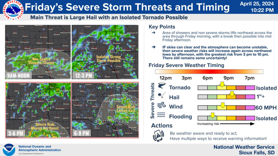
The greatest risk is expected to be between 3 p.m. and 10 p.m. for the Sioux Falls area, NWS states.
A tornado watch has been issued until 7 p.m. for multiple Nebraska and Iowa counties directly below southeastern South Dakota.
A tornado watch has been issued for parts of Iowa, Kansas, Missouri and Nebraska until 7 PM CDT pic.twitter.com/hqPPyr2WQv
— NWS Sioux Falls (@NWSSiouxFalls) April 26, 2024
This article originally appeared on Sioux Falls Argus Leader: Severe weather threat starts to diminish Friday for Sioux Falls

