Snowstorm to threaten travel delays from Rockies to Upper Midwest at midweek
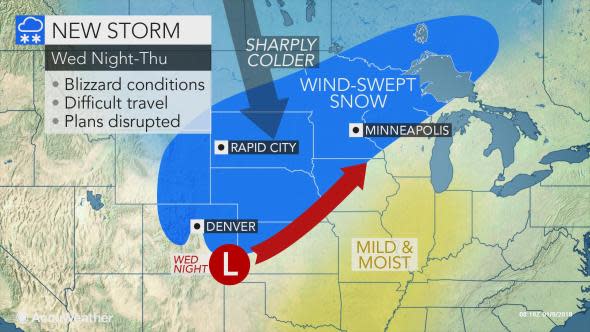
A storm will unfold over the central United States and unleash blizzard conditions for a portion of the Interstate 70 to I-90 corridor at midweek.
Cross-country travelers may opt to take a more southern route across the nation's midsection to avoid treacherous driving conditions spanning Wednesday through Thursday.
"Heavy snow will fall to the north of the storm's track as it moves from the central Rockies northeastward across the Plains, the Upper Midwest and Great Lakes," AccuWeather Storm Warning Meteorologist Brian Adams said.
Snow will unfold as a fresh outbreak of cold air invades the northwestern flank of the storm.
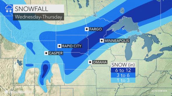
Casper, Wyoming; North Platte, Nebraska; Rapid City, Aberdeen and Sioux Falls, South Dakota; Sioux City, Iowa; Fargo, North Dakota; and Minneapolis and Duluth, Minnesota, could end up in the swath of accumulating snow where shovels and plows will be needed.
There is the potential for some areas to pick up 6 or more inches of snow.
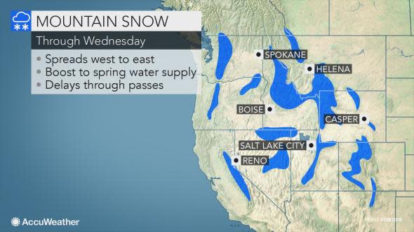
To the delight of skiers, plenty of fresh snow will bury the mountains in Wyoming and Colorado.
The swath at risk of a moderate-to-heavy snowfall accumulation includes portions of interstates 25, 29, 35, 70, 80, 90 and 94.
Gusty winds will whip around the snow.
Adams anticipates the strong winds to trigger localized blizzard conditions and significant blowing and drifting of snow in a portion of the northern and central Plains.
Airline passengers at major and regional airports from Denver to Minneapolis may also encounter delays during the height of the storm.
"Major disruptions to logistical operations, travel delays and road closures are all expected due to the variety of hazardous weather as well as the areal coverage of this storm system," Adams said.
The combination of the storm destined to bring blizzard conditions to parts of the Plains and a new storm arriving in California will spread snow over many of the mountain ranges of the Western states through Wednesday.
Mild and moist air will spread northward ahead of the storm over the Central states. This could trigger low clouds and drizzle over the western Great Lakes, Ohio Valley and mid-Mississippi Valley on Tuesday night.
Roads and sidewalks may remain cold enough in northern areas for the drizzle to freeze on untreated surfaces.
A narrow zone of ice may also occur along the southern periphery of the swath of snow spanning Wednesday night through Thursday.
In the wake of the wintry precipitation, a renewed cold wave will plunge into the Central states by the end of the week.
However, it will likely take a second storm that tracks farther to the east to bring the cold air into much of the eastern Great Lakes and the Ohio and Tennessee valleys. That second storm may bring snow to part of the Midwest.
