Storms to steer needed rain, mountain snow into California this week
A pair of storms will swing into California this week, potentially unleashing the most significant precipitation to impact the state in over a month.
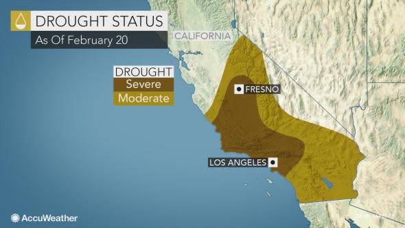
As the state contends with a worsening drought, depleted snowpack and renewed fears for the water supply in the coming months, the unsettled pattern will help to alleviate, but not fully wipe out, these concerns.
Abnormally dry winter months have caused moderate to severe drought conditions to blossom in much of central and Southern California, according to the latest report from the U.S. Drought Monitor.
"With the jet stream dipping southward along the West Coast through this week, this could help steer storm systems into California," AccuWeather Meteorologist Jordan Root said.
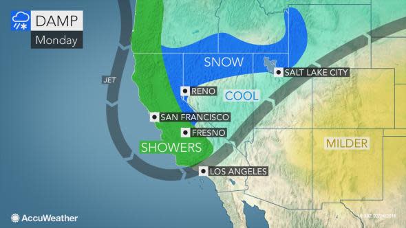
The first storm will sweep from north to south across the state Sunday night into Monday night.
"While this first storm will likely not be a major precipitation producer, it will bring rain showers and also some snow to the Sierra and Southern California mountains," Root said.
Motorists with plans to travel over Interstate 80's Donner Pass will encounter dangerous driving conditions with snow-covered roads and reduced visibility.
The snow may also impact travel over I-5's Tejon Pass and I-15's Cajon Pass in Southern California.
"Snow levels with this system can drop to 3,500 feet across the Southern California mountains with a few inches of accumulation above this level Monday night into Tuesday," Root said. "A foot of snow will be possible across the Sierra."
While rainfall from the storm will not be nearly as robust as the snow or enough to ease drought concerns, residents in San Francisco, Fresno, Los Angeles and San Diego may have to break out the umbrella as nuisance showers cross the region from Monday into Tuesday.
A more potent system will slam the Northwest during the second half of the week and may bring heavier rain and snow into California, according to Root.
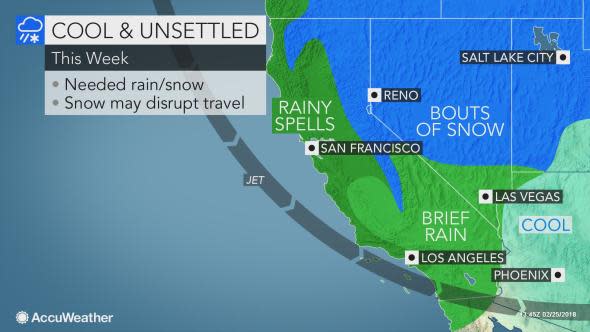
While the Sierra snowpack remains well below normal for this time of year, the storm at the beginning of March has the potential to significantly cut into the snow deficit.
Well over a foot of snow is expected to fall over the highest peaks, on top of the snowfall from earlier in the week.
Additional travel disruptions are likely over Donner Pass.
Depending on how much moisture is pulled in, the storm has the potential to produce a more significant swath of rainfall over the state than it's early-week predecessor.
Rainfall deficits and the drought would take a sizable hit should such a scenario pan out. However, the threat for flash flooding and localized mudslides would also be heightened.
At the very least, travelers to, from or through the state should anticipate slower-than-normal travel on the roads and delays at the major hubs for much of the week.
The unsettled pattern is likely to ease by the first week of March, including across the Northwest.
