Storms to pummel midwestern US to end Sunday
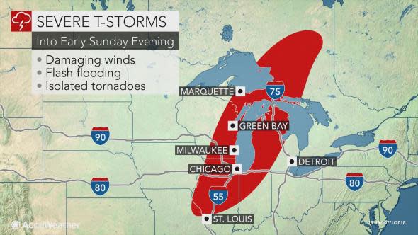
Residents of the midwestern U.S., as well as portions of Ontario, will face the threat of severe thunderstorms into early Sunday evening.
The same stormy weather that brought fatal flooding to central Iowa on Saturday night will continue eastward through the end of the weekend, impacting much of Wisconsin, Michigan and Illinois as well as portions of Iowa, Missouri and Indiana.
"A line of thunderstorms will be moving through the Chicago area during the late afternoon into the evening," AccuWeather Meteorologist Brett Edwards said.
"Due to the stormy forecast, The Overton's 400 Monster Energy NASCAR Cup Series Race has pushed up the beginning of the race to 2:32 p.m. ET," he said.
Sunday's race at Chicagoland Speedway was able to be finished before the line of showers and thunderstorms moved into the area.
Residents of these areas will need to prepare for potentially destructive weather, with the strongest storms expected to sweep across the region beginning on Sunday afternoon.
"The threat for some localized flash flooding is possible in the heavier storms, but the primary threat will be damaging wind gusts," Edwards said. A tornado or two may cause further damage.
Localized power outages are possible, as well as property damage to homes and businesses.
It will be important for motorists to slow down in areas of heavy rain as visibility is reduced and the threat of hydroplaning increases.
Strong winds can topple high profile vehicles as well as trees and powerlines.
If possible, motorists should pull over and take shelter in a sturdy building during periods of threatening weather.
In addition to slowed traffic on the roads, airline delays are likely to ensue as hail, gusty winds, lightning and heavy rain threaten major hubs in Chicago.
Once these storms clear the area late on Sunday night, the atmosphere will be prime for a sunny, less hot and less humid start to the week.
