Storm to bring rain, ice and snow to Midwest as frigid and mild air change hands
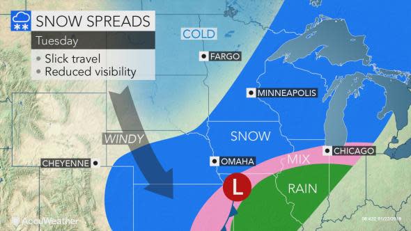
A storm will affect the Midwest with areas of snow, ice and rain as air changes hands from frigid conditions to mild and back to cold during the middle days of this week.
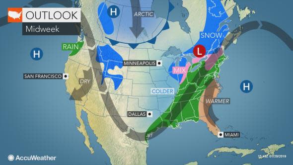
A surge of mild air will be most pronounced from the central Plains to the Ohio Valley and lower Great Lakes region spanning Tuesday and Wednesday.
The warmup will follow a couple of days of dangerously cold conditions.
While the storm will not be as strong as that of the feature that rolled through early this past weekend, it is still likely to have an adverse affect on travel conditions.
Expect delays on highways and at the airports in the North Central states due to conditions ranging from rain, fog and gusty winds to snow, ice and slippery conditions that may require deicing operations.

A deicing agent is applied to a SkyWest airplane before its takeoff, Friday, Jan. 18, 2019, at O'Hare International Airport in Chicago. (AP Photo/Kiichiro Sato)
A significant amount of snow is expected from parts of the central Plains to the Upper Midwest during Tuesday to Tuesday night.
The bulk of the snow will fall along parts of the Interstate 80, 90 and 94 corridors from Nebraska to Wisconsin.
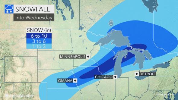
Some areas from west-central Iowa to southwestern Wisconsin may receive more than 6 inches of snow from the storm.
A wintry mix is forecast from St. Joseph, Missouri, to Cedar Rapids, Iowa, and Chicago. A change to all snow is likely around Chicago at the tail end. While rain is likely for a time in Detroit and Cleveland, both cities may start and end as snow or a wintry mix.
Motorists in this zone should expect slippery travel with enough wintry precipitation to treat, and perhaps shovel and plow.
The vast majority of the storm is forecast to bring rain from eastern Kansas to much of Missouri, central and southern Illinois, southeastern Michigan and much of Indiana, Ohio and Kentucky.
In parts of the Tennessee Valley to the eastern end of the Ohio Valley and western slopes of the Appalachians, enough rain may fall to cause urban flooding problems.
Where there are piles of snow, blocking storm drains, street flooding may be a significant problem. Even though a huge amount of rain is not foreseen, warm winds may cause the snow to rapidly melt.
Rain is likely to become mixed with or change to snow for a time in the eastern part of the Ohio Valley, parts of the Tennessee Valley and the western slopes of the Appalachians from late Wednesday to Wednesday night.

While the air behind the storm will not immediately bring a return to Arctic cold, brutally cold conditions are expected to return to the northern and central Plains on Thursday and much of the balance of the region during Thursday night and Friday.
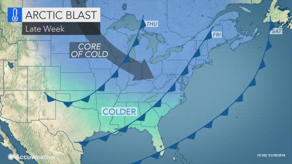
The air may be every bit as cold as that of Monday and Tuesday.
"While the cold shot and warmup will be brief during the first part of this week, we expect longer-duration cold blasts and less pronounced warmups during the latter part of January and into the first part of February," Vido said.
The pattern may offer more opportunities for snow, including in the central Plains and the Ohio Valley.
Download the free AccuWeather app to see the timing and nature of the next storm for your area.
Join host Regina Miller as she examines Forensic Meteorology and the reconstruction of weather events for legal testimonies. Steve Wistar, AccuWeather's Forensic Meteorologist and Certified Consulting Meteorologist recalls prominent legal cases where winter weather played a key role in the verdicts.

TradeWx offers protection against financial risks of snow accumulation and other weather events. Learn more on TradeWx.com.

