Steamy ocean means ‘a very, very busy season’ for hurricanes, early forecasts say
The upcoming hurricane season is shaping up to be another extremely active one, powered by the Atlantic’s record-breaking run of high temperatures.
The early season forecast from Colorado State University — a key pioneer of preseason hurricane forecasting — calls for another above-average season. The bottom line: Florida, and other coastal states, should prepare to batten down the hatches when the season begins on June 1.
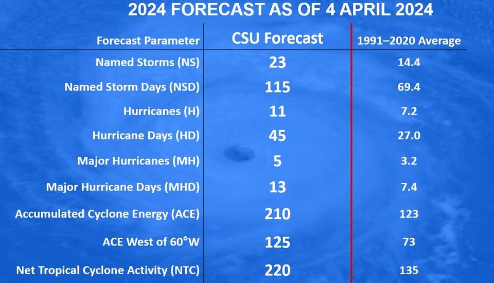
Specifically, the forecast calls for 23 named storms, 11 of which could form hurricanes and five that could strengthen into major hurricanes, Category 3 or higher. The average season has 14 named storms, 7 hurricanes and 3 major hurricanes.
That would put this season on par with some of the most active on record, including 2020, where there were so many storms the National Hurricane Center ran out of names and had to switch to an alternate list of Greek letters.
“This is the highest April forecast we’ve put out,” Phil Klotzbach, CSU meteorologist and lead author of the forecast, told a crowd of meteorologists at the National Tropical Weather Conference Thursday. “We are forecasting a very, very busy season.”
Hurricane season begins June 1 and ends Nov. 30, with a peak in August and September. Forecasting what the season could hold this early is usually seen as a tough task. The gold standard — from the National Oceanic and Atmospheric Administration — is in May.
But unlike last year, where two major weather phenomena with opposite effects duked it out in the Atlantic, this year all early forecasts to date, including Accuweather and Weather Tiger, are pointing to one thing: an active season.
“At this long lead time, there’s a lot of uncertainty. This year, I’d say we’re a lot more confident than we were last year,” Klotzbach said.
The main factor for the high numbers on this forecast is the Atlantic, where sea surface temperatures are running at temperatures that are more common in July, said Brian McNoldy, a senior research associate at the University of Miami.
READ MORE: The Atlantic is hotter, earlier. That’s a bad sign for hurricane season, Florida corals
“This year it has not (and will not) get below 20°C for the first time in recorded history!” he posted on X, formerly known as Twitter.
Update with March's monthly-average sea surface temperature data: the North Atlantic continues to shatter records. In fact, this year it has not (and will not) get below 20°C for the first time in recorded history!
Data: NOAA ERSSTv5 pic.twitter.com/9pqFr19S27— Brian McNoldy (@BMcNoldy) April 4, 2024
And there’s no sign the Atlantic is cooling off significantly anytime soon. In fact, Klotzbach said, if the Atlantic warms at the slowest possible rate for the next few months, it would still be one of the top five warmest years in the Atlantic on record.
Another factor that could push this season to new-record territory is the shift in global weather phenomena from El Niño to a potential La Niña. El Niño is usually marked by a less active hurricane season in the Atlantic, thanks to the wind patterns that are more likely to break up storms as they attempt to form.
Last year’s hurricane season included an El Niño, but its storm-dampening effects were overwhelmed by the steamy Atlantic.
Current models from NOAA and beyond call for the still-remaining El Niño effect to die out in the next few months, and the chances that it will be replaced in the peak of hurricane season by a La Niña, which is linked to a friendlier Atlantic for storm formation, are rising by the week.
Another storm metric that stands out in the CSU forecast is ACE, or accumulated cyclonic energy. That’s a measure based on how long a storm says at the range of hurricane strength categories. With each hurricane, the number rises — an indicator of the strength of the overall season.
This season, CSU calls for a very high ACE of 210, when an average season sees only 123. Compare that to 2020, where we saw 30 named storms, 14 of which became hurricanes, which had an ACE of 179.8. This year’s prediction of 210 still falls below the highest seasonal ACE on record — 250, from 2005.
But in his talk on Thursday, Klotzbach told the crowd CSU’s models showed a potential for up to 269 ACE this year, which they adjusted down in the final forecast.
“All the way up to the most active season on record, potentially, and all the way down to what we saw last year,” he said. “We’re talking ACE at basically record levels.”
Still, Klotzbach warned, an overactive season does not immediately translate to more landfalls. It just increases the odds. He warned residents in coastal states, like Florida, to prepare ahead of the start of the season.
“Obviously it only takes that one hurricane to make this year a busy season,” he said.

