St. Lucie County updates: Hurricane Ian impacts Wednesday in Port St. Lucie, Fort Pierce
Editor's note: Here are live updates for Thursday, Sept. 29.
TCPalm has staff across Port St. Lucie and Fort Pierce to provide updates on Hurricane Ian’s impact Wednesday to St. Lucie County.
7:19 p.m. - Road woes
The St. Lucie County Sheriff's Office reported street flooding throughout the county. Sheriff’s officials advised motorists to use caution. The roads the agency indicated are experiencing issues include:
10500 block to the 11000 block of Carlton Road
113 Easy Street closed after flooding
Georgia Avenue and South 13th Street is closed after a gas leak
Selvitz Road and St. James Drive
Northwest East Torino Parkway and West Midway Road
Northeast Floresta Drive and Ardsley Drive
2400 block of Trowbridge Road
Midway Road westbound closed at Torino Parkway
Southwest Savona Boulevard and Southwest California Boulevard
7:05 p.m. - Surf’s up!
At least one surfer took advantage of the big swells at South Beach in Fort Pierce Wednesday evening, reported Jon Santucci. Up the shore at Jetty Park, onlookers gathered to watch the waves.
Big wave hunting at South Beach in Fort Pierce on Wednesday night #tcweather pic.twitter.com/p4ycuGKInF
— Jon Santucci (@JonSantucci) September 28, 2022
Hanging out at the jetty in Fort Pierce. It’s packed (behind me). Wind and waves definitely picking up here. #tcweather pic.twitter.com/UZoR6y4fFE
— Jon Santucci (@JonSantucci) September 28, 2022
5:57 p.m. - Weather conditions to deteriorate overnight
A tropical storm warning remains in effect for Martin, St. Lucie and Indian River counties Wednesday evening, with conditions expected to deteriorate overnight, according to the National Weather Service’s Melbourne office.
The entire Treasure Coast is also under tornado and flood watches.
Conditions will deteriorate tonight. TS to hurricane force winds are expected. The threat of significant to catastrophic flooding is expected to develop tonight-Thu for areas from N Osceola & N Brevard north including metro Orlando. Flooding can be especially dangerous at night. pic.twitter.com/BZ0R9ilRyr
— NWS Melbourne (@NWSMelbourne) September 28, 2022
5:15 p.m. - Additional power outages reported
There are approximately 220 FPL customers currently without power in St. Lucie County. Power has been restored to about 830. The Fort Pierce Utilities Authority has reported no outages.
4:25 p.m. - Tornado watch reissued
The National Weather Service’s Melbourne office has issued a tornado watch for all of St. Lucie County through 1 a.m. Thursday. The previous watch ends at 5 p.m. Isolated wind gusts of up to 60 miles per hour are possible, as is half-inch-sized hail.
More than 3.9 million people are affected by the watch, which stretches from Volusia to Martin counties.
A tornado watch has been issued for parts of Florida until 1 AM EDT pic.twitter.com/IqgD6fjwfD
— NWS Melbourne (@NWSMelbourne) September 28, 2022
3:45 p.m. - Cleveland Clinic closes ambulatory offices
Cleveland Clinic Martin Health, which encompasses a number of St. Lucie County facilities, will close its ambulatory clinics through 10 a.m. Thursday. Ambulatory surgery centers will reopen at noon.
The St. Lucie West Emergency Department will stay open.
Click here for a complete listing of area closures and cancellations.
3:30 p.m. - Relatively few power outages reported
There are approximately 70 FPL customers currently without power in St. Lucie County. Power has been restored to about 800. The Fort Pierce Utilities Authority continues to report no outages.
2:54 p.m. - Kids play seaside despite storm warning
The threat of tropical storm-force winds isn’t keeping some children from playing at the South Causeway Beach in Fort Pierce, observed reporter Jon Santucci.
Kids playing at the South Causeway Beach on Wednesday afternoon #tcweather pic.twitter.com/YOcH4zrkZ3
— Jon Santucci (@JonSantucci) September 28, 2022
2:12 p.m. - Shelters combined, bus service suspended
Due to low turnout at the Fort Pierce Central High School emergency shelter, those patrons have been relocated to Fort Pierce Westwood Academy, county spokesperson Erick Gill said in a statement.
In addition, St. Lucie’s Area Regional Transit bus service was suspended at 2 p.m. and will remain closed through Thursday.
Waste Pro and the St. Lucie County Landfill will decide hours of operation at 5 a.m. Thursday.
2:02 p.m. - North Causeway docks flooded
Though not uncommon, the Indian River Lagoon has flooded two of four docks and the boat ramps at North Causeway Island Park in Fort Pierce, reports editor Cheryl Smith.
The Indian River Lagoon covers 2 of the 4 docks and the boat ramps at North Causeway Island Park in Fort Pierce, but that's not all that unusual. pic.twitter.com/eiqEKxzYXu
— Cheryl Smith (@CherylS73467955) September 28, 2022
Full moon is causing higher tides in the #IndianRiverLagoon in #FortPierce at the North Causeway Island Boat Ramp, which is already under water ahead of #HurricaneIan. #TCweather pic.twitter.com/spI5J5vjWM
— Laurie K. Blandford (@TCPalmLaurie) September 28, 2022
1:31 p.m. - Unmoored in the storm
An unmoored sailboat crashed into the south side of the North Causeway Bridge in Fort Pierce before drifting away, dragging its anchor, reported Laurie K. Blandford.
Here’s a sailboat that appears to have been unmoored and crashed into the south side of the North Causeway Bridge in #FortPierce ahead of #HurricaneIan. #TCweather pic.twitter.com/RlGzgE0yiA
— Laurie K. Blandford (@TCPalmLaurie) September 28, 2022
And here’s a peephole view of the sailboat that came unmoored in the #IndianRiverLagoon and crashed into the south side of the North Causeway Bridge in #FortPierce. #TCweather pic.twitter.com/9vB754yeFJ
— Laurie K. Blandford (@TCPalmLaurie) September 28, 2022
It’s loose! @MyFWC officers walk the North Causeway Bridge in #FortPierce toward the unmoored sailboat dragging its anchor through the #IndianRiverLagoon ahead of #HurricaneIan. #TCweather pic.twitter.com/nzfEP9IE1i
— Laurie K. Blandford (@TCPalmLaurie) September 28, 2022
When @TCPalmHasert goes above and beyond, literally, to get the photos for @TCPalm. #HurricaneIan #Tcweather pic.twitter.com/crALSMt4vN
— Laurie K. Blandford (@TCPalmLaurie) September 28, 2022
1:14 p.m. - Some high school football games moved
The impacts of Hurricane Ian are being felt along the Treasure Coast and for high school sports, there won’t be much action.
Martin, St. Lucie, Indian River and Okeechobee counties are all off from school Wednesday and Thursday, which will force the postponements of all extracurricular activities due to the anticipated heavy rainfall and tropical storm-force winds for the area.
St. Lucie County schools are anticipated to resume on Friday.
1 p.m. - EOC still operating at level 2
The St. Lucie Emergency Operations Center remains at a level 2, said Public Safety Director Rangel Guerrero. Flooding is still a top concern. No other shelters are expected to open, and no evacuations are expected.
County officials continue to urge residents to review their hurricane preparedness plans and have kits on standby with medication, first aid, nonperishable goods and water.
Noon - Rum runners on the jetty
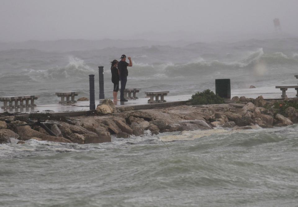
Marci and Carey Whitley were among the constant flow of people late Wednesday morning walking the south jetty at the Fort Pierce Inlet ahead of Hurricane Ian.
The Whitleys live along Indian River Drive in Fort Pierce and came to Jetty Park because they wanted to see the waves. They typically don’t have flooding issues during storms because their home is on high ground.
The couple sipped their respective pink jetty rum runners in brown paper bags they just picked up from the nearby Jetty Lounge dive bar.
“We’re crazy for even drinking at this time of the day,” she said.
Dozens of curious people — many with those same rum runners — strolled the paved jetty as waves crashed over the walkway. The swell produced waves south of the jetty, which typically happens only during storms.
When a rain band arrived, they would run from the beach and take cover under the pavilions or in their vehicles before it subsided, before venturing back out to the beach.
11:30 a.m. - Tropical storm warning still in effect
St. Lucie County remains under a tropical storm warning, according to the National Weather Service office in Melbourne.
Coastal areas can expect tropical storm-force winds of 35-45 miles per hour through Thursday afternoon, with wind gusts of up to 70 miles per hour possible. Localized storm surge may potentially reach 2 feet above ground through Friday evening.
Inland, people are advised to “prepare for considerable wind damage.”
10:20 a.m. - Winds hit Indian River Lagoon
The waters of the Indian River Lagoon are choppy in St. Lucie Village, where reporter Laurie K. Blandford captured wind jostling stop signs.
Windy and choppy on the #IndianRiverLagoon at St. Lucie Village in #FortPierce. #TCweather pic.twitter.com/CzBSYEgBtf
— Laurie K. Blandford (@TCPalmLaurie) September 28, 2022
10:17 a.m. - Wet roads in Fort Pierce
There’s minor flooding on Old Dixie Highway in Fort Pierce, en route to St. Lucie Village, as witnessed by reporter Laurie K. Blandford.
Heading down Old Dixie Highway toward St. Lucie Village in #FortPierce ahead of #HurricaneIan. #TCweather pic.twitter.com/G7GUDhoihp
— Laurie K. Blandford (@TCPalmLaurie) September 28, 2022
9:28 a.m. - Make-your-own sand bags
Sports reporter Jon Santucci saw people visiting Martin Luther King Jr. Dreamland Park in Fort Pierce to assemble sand bags in case of flooding.
People have been stopping by MLK Dreamland Park in Fort Pierce this morning to make sand bags. #TCWeather pic.twitter.com/EH0SvJUai3
— Jon Santucci (@JonSantucci) September 28, 2022
8:30 a.m. - Emergency shelters to open
Can’t see the Google Map above? Click here to view Treasure Coast emergency shelters.
St. Lucie county officials announced select emergency shelters in St. Lucie County, including those for people who require medical support (often called “special needs shelters”), would open at 10 a.m.:
General population: Fort Pierce Central High School, 4101 S. 25th St., Fort Pierce
For transportation, call 772-460-HELP (4357), from 7 a.m. to 5 p.m. Wednesday
People who need medical support: Havert L. Fenn Center, 2000 Virginia Ave., Fort Pierce
For transportation, call 772-462-1778 and press 1 for reservations, from 7 a.m. to 5 p.m. Wednesday
People with pets: Fort Pierce Westwood Academy, 1801 Panther Lane, Fort Pierce.
8:13 a.m. - Cloudy, quiet at Fort Pierce jetty
Under gray skies, waves crash on the rocks at the Jetty Park in Fort Pierce. Few people are at the popular storm-watching spot, according to sports reporter Jon Santucci.
A little surprised to see the jetty in Fort Pierce so quiet this morning. Usually a popular spot whenever the wind is kicking up waves. #TCWeather pic.twitter.com/3NwDgn3bMn
— Jon Santucci (@JonSantucci) September 28, 2022
4:58 a.m. - Tornado watch issued
The National Weather Service’s Melbourne office issued a tornado watch for all of St. Lucie County through 5 p.m. While no hail is expected, the agency warned of likely tornadoes and isolated wind gusts of up to 60 miles per hour.
More than 12.2 million people are affected by the watch, which stretches from Orlando to Miami and as far west as Sarasota.
A tornado watch has been issued for parts of Florida until 5 PM EDT pic.twitter.com/td2qarojOj
— NWS Melbourne (@NWSMelbourne) September 28, 2022
This article originally appeared on Treasure Coast Newspapers: Hurricane Ian: Tropical storm warning for St. Lucie County, Florida

