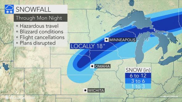
Blizzard to continue risk of dangerous travel from Nebraska to Michigan into Monday night
Heavy snow and blizzard conditions will continue to snarl travel and disrupt daily routines in part of the midwestern United States into Monday night.
Enough cold air will roll in with a slow-moving storm to unleash snow in areas where temperatures were in the 40s and 50s F at the end of last week.
Despite the prior mild conditions, snow will fall at a fast enough rate for roads to transition from wet to slushy and snow-covered in a matter of minutes.
"People venturing along portions of interstates 29, 70, 80, 90 and 94 may run the risk of getting stuck or encountering dangerous conditions," AccuWeather Senior Meteorologist Alex Sosnowski warned in advance of the storm.
In Stanton, Nebraska, the snow fell and drifted at such a heavy rate that motorists became trapped in their vehicles on Monday morning. Drifts up to 5 feet were reported.
A narrow swath from Nebraska to southeastern South Dakota, northwestern Iowa, southern Minnesota, north-central Wisconsin and the Upper Peninsula of Michigan will be buried under 6-12 inches of snow, with localized amounts up to 18 inches.
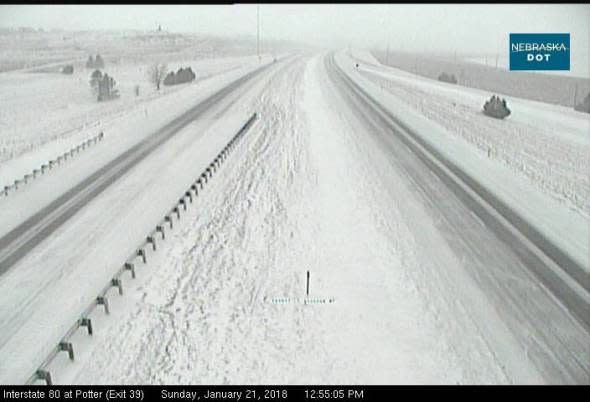
Snow covered Interstate 80 at the Potter, Nebraska, exit on Sunday, January 21, 2018. (Web camera/Nebraska Department of Transportation)
Snowfall rates of 1-2 inches per hour with blizzard conditions can make travel extremely dangerous, if not impossible. Roadway visibility could be a quarter of a mile or less at the height of the storm.
There will be an extreme variation in snowfall totals on the northern side of the storm. A distance of less than 50 miles could mean the difference between receiving little to no snow or over half a foot.
Roads began closing across eastern Colorado, western Kansas and central Nebraska on Sunday evening as heavy snow and howling winds caused road conditions to deteriorate.
"Even where only light snow falls, increasing winds will cause extensive blowing and drifting snow," Sosnowski said.
In addition to dangerous travel, residents should prepare for school closures and other disruptions to daily routines. Air travel can be severely impacted.
As the snowstorm crossed the Denver area on Sunday, nearly 200 flights were canceled at the city's international airport. Between 3 to 6 inches of snow fell around the metro area with higher amounts across the foothills of the Rockies.
Minneapolis/St. Paul will likely end up being on the northern fringe of the heaviest snowfall. Enough snow will fall in the Twin Cities to lead to a treacherous evening commute Monday and morning commute on Tuesday.
After receiving rain and even a rumble of thunder from the storm on Monday, enough cold air may sweep into Madison and Milwaukee, Wisconsin, and Chicago for the storm to end as a bit of snow on Monday night.

"While the heaviest snow is expected from Nebraska to the Upper Peninsula of Michigan, a separate area of snow may develop on Monday night and leave a quick few inches and slippery travel along the border of Wisconsin and Illinois," AccuWeather Senior Meteorologist Kristina Pydynowski said.
"A bit of this snow can sweep through Chicago during the Tuesday morning commute," she said.
Ice may occur prior to, or in lieu of, snow in some communities from north-central Kansas to the Lower Peninsula of Michigan.
Benign weather will settle in for snow removal and cleanup operations across the Central states on Tuesday, followed by a big warmup later in the week.
