Snowstorm, cold rain and severe weather threaten southeastern US into Friday night
A rare cold, early-December storm will bring everything from snow to sleet, rain and severe thunderstorms to the southeastern United States into early Saturday.
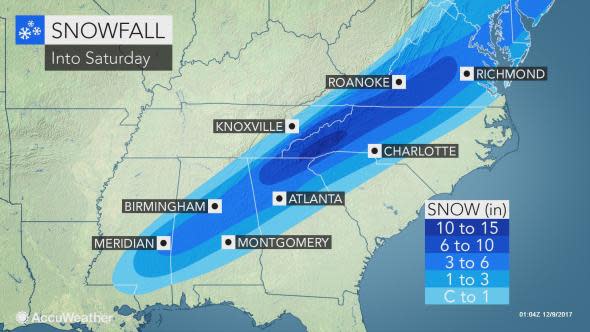
The storm has had a history of bringing slippery roads to the Houston area and snow to Brownsville, Texas, and northern Mexico. A large swath of 3-6 inches of snow is forecast with locally higher amounts.
Accumulating snow will continue in a stripe from southern Alabama to northern Georgia and western North Carolina.
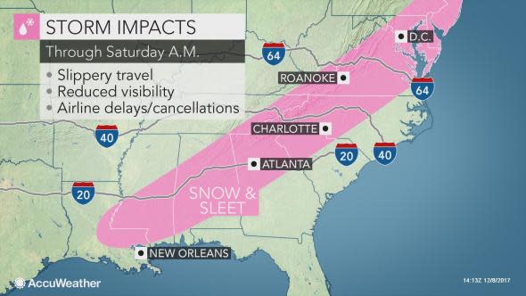
While roads will be mainly wet from the storm, where the snow falls hard into Saturday morning, slushy and slippery conditions can develop.
"Travel is likely to be difficult near and northwest Atlanta, Greenville and Charlotte," according to AccuWeather Senior Meteorologist Frank Strait. "Some motorists may get stuck along this stretch of Interstate-85 and portions of i-26, I-40, I-59, I-75 and I-77."
Over a foot of snow in the mountains of western North Carolina and northern Georgia.
Airline delays will mount, due to poor visibility, a low cloud ceiling and, in some cases, aircraft-deicing activities. Some flight cancellations are possible.
The snowstorm will affect the coastal areas of the Northeast on Saturday. Flights with destinations in the Washington, D.C., to New York City and Boston corridor may be affected.
In addition to being a photogenic storm, the wet, clinging nature of the snow may weigh down tree limbs to the point where they bend and break. This may lead to sporadic power outages, especially in the southern Appalachians.
Farther southeast, a cold rain will extend from the Virginia capes to southeastern North and South Carolina, southeastern Georgia and northern Florida.
Meanwhile, the storm will become potent enough to trigger severe thunderstorms across the Florida Peninsula into early Saturday.
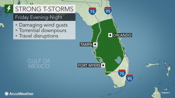
The greatest threat from the storms will be strong wind gusts that can cause sporadic power outages and minor property damage. The rain may be heavy enough to lead to brief urban flooding and travel delays.
A couple of the strongest storms may produce a brief, spin-up tornado.
The thunderstorms will mark the leading edge of a sweep of chilly air across the Sunshine State for this weekend.
The air will get cold enough for a freeze in parts of the Deep South in the wake of the storm this weekend.
Motorists and pedestrians should be alert for icy patches in the wake of the storm where melting snow or standing water had time to freeze before evaporating.
