Snowstorm delivers plowable powder to over 18 states before next Arctic invasion

Wax the skis, ready the sleds and brace for more travel disruptions as a storm will continue to bring enough snow to shovel and plow from Iowa to New Jersey, including at least 115 million people into Friday evening, AccuWeather meteorologists warn. In the wake of the storm this weekend, the coldest air of the season so far will invade much of the eastern United States.
A storm that AccuWeather meteorologists have been tracking since it was over the Pacific Ocean more than a week ago is at hand.
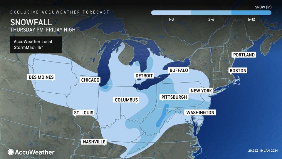
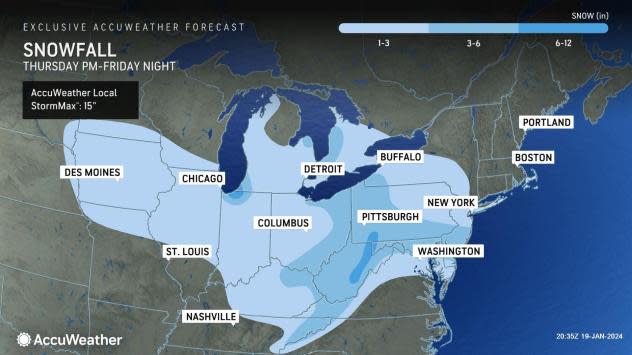
The same storm unloaded travel-snarling snow, damaging ice and drenching rain from the coastal Northwest to the interior West earlier this week. The storm will produce a broad zone of 1-3 inches of snow with large pockets where 3-6 inches of snow or more will fall prior to it exiting the mid-Atlantic coast Friday night.
 |
The heavier pockets of snow will be created by extra moisture from the Great Lakes and the Atlantic Ocean, as well as other atmospheric factors.
"The dry, powdery nature of the snow and cold ground will lead to immediate accumulations on the roads so that soon after the storm begins, slippery conditions will develop," AccuWeather Senior Meteorologist Brett Anderson said. In some areas, a fresh coating of snow was already on the ground from an early part of the storm that arrived on Thursday.
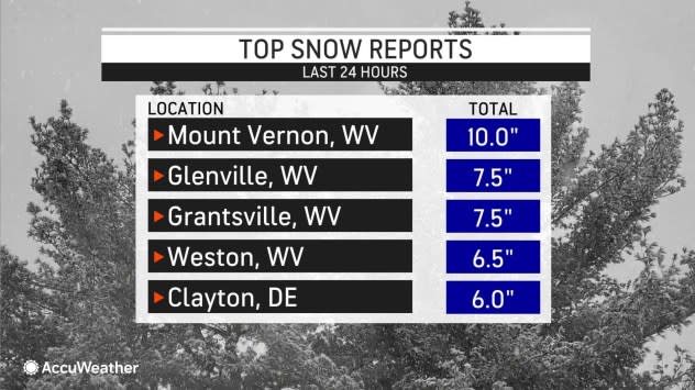
Over 1,000 miles of Interstate 80 have been affected by accumulating snow as well as hundreds of miles of Interstates 64, 70 and 90 and many others from the Midwest to the Northeast.
 |
De-icing operations were in full swing at the airports, including the major hubs of Detroit, Pittsburgh, Philadelphia, Washington, D.C., and New York City on Friday. Flight delays and cancellations will escalate to close out the week and start the weekend.
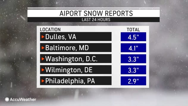
The Federal Aviation Administration (FAA) issued a ground stop for incoming flights to Reagan National Airport, D.C., earlier Friday, due to snowy and icy conditions. As of 3 p.m. ET, the Washington, D.C., area had already picked up 3-4 inches of snow from the storm. The FAA issued similar ground stops for the New York City area airports for a time on Friday.
 |
The dry, powdery snow will be easy to shovel and plow in most cases, but it will be subject to blowing and drifting as frigid blusters develop in the wake of the storm early this weekend, Anderson said. This may require additional clearing of some roads, sidewalks and parking lots. However, from a skier or boarder viewpoint, there's nothing like fresh natural powder.
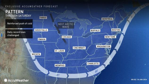
As the cold air rushes across the Great Lakes, bands of snow will set up in a northwest-to-southeast trajectory or a west-to-east fashion this weekend. This represents a shift away from the heavy snow set up in Buffalo, New York, with more heavy snow directed toward the southwestern New York ski resorts, northwestern Pennsylvania and northeastern Ohio.
 |
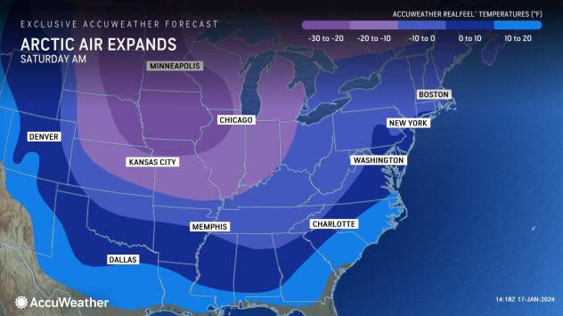
As high pressure originating from the Arctic settles in this weekend and lingers into the start of the week, temperatures will run 10-15 degrees below the historical average for the middle of January in much of the Eastern states.
This will result in daytime highs in the teens and 20s and nighttime lows below zero in the Northeast, with the mercury falling lower than 10 degrees below zero in the coldest spots. In the Southeast, outside of the Florida Peninsula, daytime highs will generally be in the 30s and 40s, with nighttime lows in the 20s.
Any breeze will be painful and piercing and will contribute to AccuWeather RealFeel® Temperatures 10-20 degrees lower than the actual temperature.
 |
At this level, there will be a risk of frostbite and hypothermia for those not properly dressed in the East and South and life-threatening conditions in the North Central states.
However, where winds drop off and the sky becomes clear, temperatures could drop substantially lower -- perhaps 10 degrees lower or more Saturday night to Monday night.
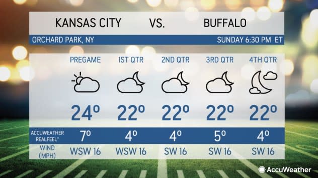
It will be another frigid weekend for football fans with Baltimore hosting Houston on Saturday afternoon and Kansas City heading to Buffalo for a highly-anticipated matchup on Sunday night.
 |
The AccuWeather RealFeel® Temperatures are predicted to be in the single digits at both games.
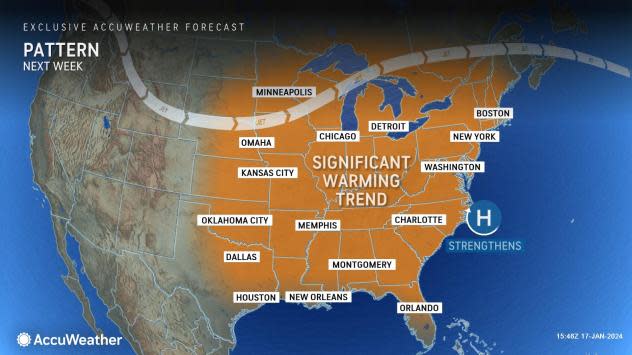
Temperatures will trend upward next week in much of the East. However, as milder and more moist air flows over cold ground or snow cover, areas of fog and drizzle are likely to break out. Where ground temperatures remain near the 32-degree Fahrenheit mark, thin, dangerous sheets of clear ice may form.
 |
AccuWeather meteorologists expect a period of substantial ice to develop in parts of the Plains and Mississippi Valley early next week as a new storm approaches. Areas of ice and snow are likely from the Upper Midwest to parts of the Northeast, spanning Tuesday to Thursday, where moisture from the storm collides with resisting cold air from Canada.
Want next-level safety, ad-free? Unlock advanced, hyperlocal severe weather alerts when you subscribe to Premium+ on the AccuWeather app. AccuWeather Alerts™ are prompted by our expert meteorologists who monitor and analyze dangerous weather risks 24/7 to keep you and your family safer.
