Snow from western US to streak onto northern Plains at midweek
The same storm kicking off the week with snow over parts of the western United States will return a narrow swath of snow to the northern Plains at midweek.
Following Saturday's record rainfall in Seattle and other communities in western Washington, a new storm is expected to sweep from the West Coast to the Rockies into Tuesday.
While no rain will reach Southern California, showers and heavier bouts of rain will dampen the I-5 corridor from Bakersfield, California, to Portland, Oregon, and Seattle, Washington, into Monday.
Thunderstorms capable of producing small hail may also rumble across northern and Central California on Monday.
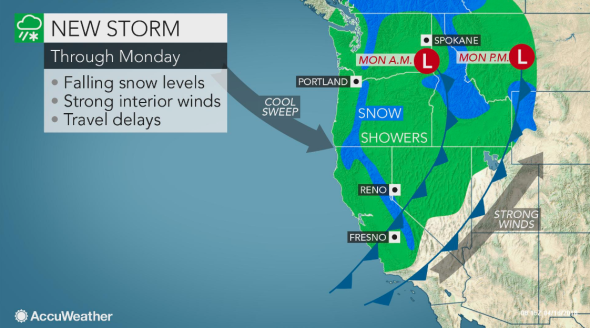
The wind and snow associated with the storm may prove more problematic for travelers across the Intermountain West.
Falling snow levels will bring snow and difficult travel to most passes. This includes I-90's Snoqualmie Pass and I-80's Donner Pass.
Snow may also fall at times over I-5's Siskiyou Pass, but any light snow during the day would struggle to stick to the highway.
"As cooler air pours in, 1-2 inches of snow can whiten Salt Lake City later Monday night into Tuesday morning," AccuWeather Meteorologist Brett Rossio said. "The majority of the snow will be on grassy and elevated surfaces."
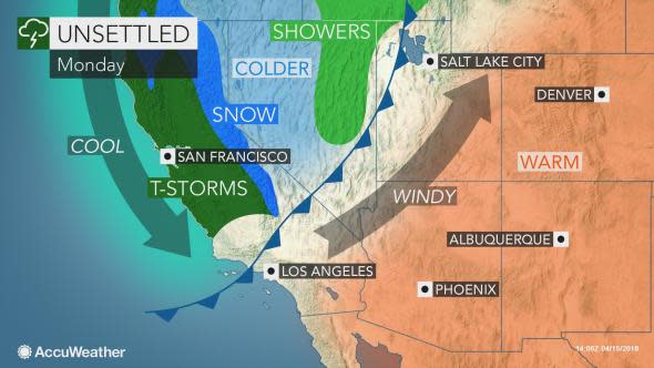
Rossio anticipates heavier snow and more travel problems in the neighboring Wasatch Mountains.
Ahead of the snow in Utah, strong winds will develop from the deserts of California to Arizona, Utah and Wyoming on Monday.
In addition to creating dangerous crosswinds and blowing dust for motorists, the winds will significantly heighten the fire danger across the Desert Southwest.
Snow to return to the north-central US at midweek
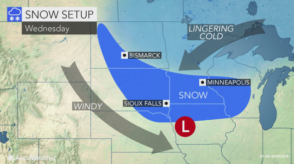
The storm will emerge onto the Plains at midweek with rain or a wintry mix at its onset. Enough cold air may then plunge into the western side of the storm for a changeover to snow.
The impacts from this storm are not expected to be as widespread as the weekend's blizzard. The swipe of snow may be narrow (200 miles wide or less) between the 1-80 and I-94 corridors.
However, the storm may still drop enough snow for shoveling and plowing to be required in some communities. Residents in these areas could be dealing with a new round of slippery travel and disruptions to daily routines.
Sioux Falls, South Dakota, and Minneapolis are at risk of receiving more snow at midweek. This month is already the snowiest April on record in both cities.
How disruptive the snow will be across the North Central states will be determine by its intensity.
"At this time, the potential exists for at least a half a foot or more of accumulation in the axis of heaviest snow," according to AccuWeather Meteorologist Kyle Elliott. "Some locations in this threat area received 1-2 feet of snow from the weekend blizzard."
Roads and sidewalks will remain mostly wet during the day unless the snow falls hard enough to overcome the effects of the strong April sun.
Light snow can more easily stick to paved surfaces at night when temperatures are below freezing.
Motorists may also have to contend with the snow getting blown around by gusty winds. However, the strongest winds may howl just south of the snow zone and bring a risk for power outages and hazards to high-profile vehicles.
A weakened version of the storm may continue to track eastward, delivering rain and lighter snow to the Great Lakes and Northeast later in the week.
Due to the ongoing spell of frigid air and multiple bouts of heavy snow slamming the north-central U.S., a delayed start to the growing season is virtually inevitable.
"With all of the snow on the ground, soil temperatures well below normal and muddy ground to follow the snow melt, planting will be delayed in parts of the corn belt," AccuWeather Senior Meteorologists Mike Doll and Joe Lundberg warned.
It could take until the last week of April, or even longer, for a consistent stretch of temperatures more typical of spring to return to the Midwest.
