Snow possible through weekend, winter storm could hit Sioux Falls early next week
Sioux Falls may see more snow through the weekend and beyond, according to the National Weather Service, with a winter storm potentially affecting the area early next week.
The NWS of Sioux Falls is forecasting between 0 and 1 inch of snow in Sioux Falls through Saturday, with chances of flurries throughout Friday night and Saturday.
A Monday storm has the possibility of bringing more snow to the area, though the forecast for the storm is still uncertain.
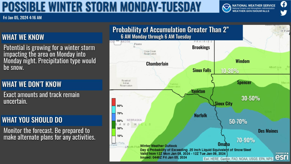
As of Friday afternoon, the NWS said Sioux Falls had a 10%-30% chance of seeing more than two inches of snow between Monday and Tuesday, with probabilities increasing in areas further south such as Sioux City and Omaha. Temperatures during the next two weeks are also expected to be below average.
Sioux Falls has had an exceptionally dry winter. Since July 1, the city has only seen 2 inches of snowfall, well below the average of 17.3 inches.
The forecast for the next week is below:
This afternoon: Patchy fog before 1p.m. Otherwise, cloudy, with a high near 31. South wind 10 to 15 mph, with gusts as high as 20 mph.
Tonight: A chance of flurries between 7 and 10 p.m., then a chance of snow after 10 p.m. Cloudy, with a steady temperature around 30. South wind 5 to 10 mph becoming west southwest after midnight. Chance of precipitation is 40%.
Saturday: A 40% chance of snow. Cloudy, with a high near 31. Northwest wind 5 to 15 mph, with gusts as high as 20 mph.
Saturday Night: A 40% chance of snow before 7 p.m. Mostly cloudy, with a low around 14. Northwest wind 5 to 15 mph, with gusts as high as 20 mph.
Sunday: Mostly sunny, with a high near 26. North northwest wind around 5 mph becoming east southeast in the afternoon.
Sunday Night: A 30% chance of snow after 1 a.m. Mostly cloudy, with a low around 18. East wind 5 to 15 mph, with gusts as high as 20 mph.
Monday: Snow likely, mainly between 7 a.m and 1 p.m. Mostly cloudy, with a high near 28. Chance of precipitation is 60%.
Monday Night: A 50% chance of snow, mainly before 7 p.m. Mostly cloudy, with a low around 14.
Tuesday: Mostly sunny, with a high near 25.
Tuesday Night: Mostly cloudy, with a low around 11.
Wednesday: A 20% chance of snow. Mostly cloudy, with a high near 28.
Wednesday Night: A 20% chance of snow. Mostly cloudy, with a low around 6.
Thursday: A 30% chance of snow. Mostly cloudy, with a high near 15.
This article originally appeared on Sioux Falls Argus Leader: Snow possible through weekend and into next week for Sioux Falls

