A significant severe weather threat could take shape for Monday. Here’s what we know
A widespread and significant severe thunderstorm threat could take shape in the central US early next week, putting millions at risk of destructive wind gusts, hail and tornadoes.
Forecasts are still somewhat uncertain and will solidify through the weekend. But it’s already clear a large portion of the Plains, Mississippi Valley and Midwest will need to keep a very close eye on the weather Monday and Tuesday.
An unseasonably warm weekend will help prime the atmosphere for damaging storms early next week. This warmth, in tandem with a surge of moist air from the Gulf of Mexico, will leave areas from Texas to Iowa vulnerable Monday.
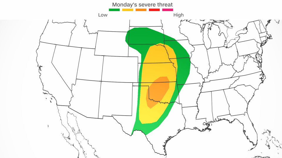
A Level 3 of 5 risk of severe thunderstorms is in place from northern Texas to southern Kansas Monday, according to the Storm Prediction Center.
Thunderstorms are likely to kick off Monday afternoon in parts of Texas, Oklahoma and Kansas but the strongest storms with the most hazardous impacts may not get underway until the evening.
Storms, especially the ones that form later in the day, could produce hail from the size of quarters to baseballs, damaging wind gusts and tornadoes.
The greatest threat for tornadoes may center around Oklahoma.
This is a classic springtime setup for Texas and Oklahoma where severe weather activity typically peaks in May, but both April and June are very active months.
Storms are forecast to expand in scope and strength into Monday night and reach parts of Nebraska, Iowa, Missouri and Arkansas. Thunderstorms could be simultaneously ongoing over much of the Plains and parts of the Mississippi Valley Monday night.
Oklahoma City, Fort Worth, Wichita, Kansas, and Kansas City, Missouri, are just a few areas that could have damaging storms roaring through after dark. Some of these storms could produce tornadoes.
That could prove to be a deadly situation: It’s difficult to spot a tornado at night, even for those who are awake or are awoken by warnings. Nighttime tornadoes are twice as likely to be deadly as those that occur during the day, a 2022 study found.
The best way to stay safe during a nocturnal tornado threat is to have multiple ways to receive severe weather warnings. At the very least, make sure emergency alerts are enabled on your smartphone. Charge devices ahead of time and set phones or alarms on a loud volume so you’re not caught unaware.
Monday night’s powerful storms are forecast to last into Tuesday morning, but their exact strength and location will determine what areas are at risk of dangerous storms for the rest of the day.
Although Tuesday’s severe setup heavily depends on how Monday night plays out, it’s likely that storms track through more of the Mississippi Valley and parts of the Midwest.
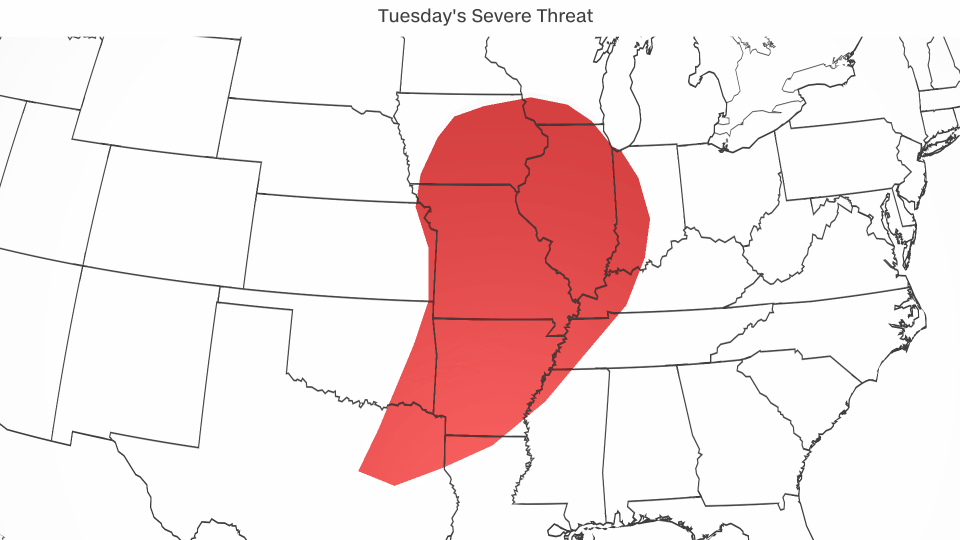
The main threats with any storm Tuesday are forecast to be quite similar to Monday’s: damaging wind gusts, hail and possible tornadoes.
Severe thunderstorms early next week may also produce periods of heavy rainfall, which could lead to flooding issues.
North of the severe weather, heavy rain from the same storm system will drench a widespread area including the Dakotas and parts of the Midwest.
Gusty winds will also develop in areas west of the stormy weather early next week. Frequent wind gusts of 40 to 60 mph in portions of the Rockies could cause damage to trees or power lines.
These winds may also raise the risk for wildfire spread, especially in parts of New Mexico where nearly 75% of the state is experiencing drought, according to the US Drought Monitor.
For more CNN news and newsletters create an account at CNN.com

