Significant blast of snow to blanket the Prairies, travel disruptions ahead
Welcome to meteorological spring! A significant snowstorm is on the way for the majority of the Prairies.
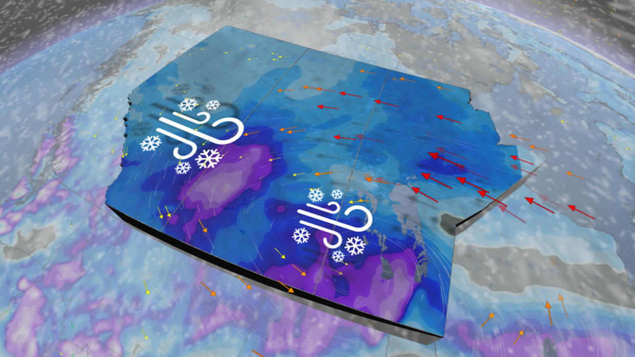
Confidence is high that a significant amount of snow will blow across the Prairies this weekend. Travel will be highly disrupted, with blowing snow and periods of blizzard like conditions greatly reducing visibilities on the road.
The storm begins Saturday in south and central Alberta and Saskatchewan, intensifying as the system makes its way east into Manitoba.
RELATED: Avalanche warning issued as snow piles up in the Rockies
Saturday - Sunday
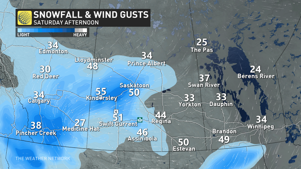
The snowfall will start moving across southern Alberta on Saturday morning, bringing light and fluffy snowfall across the province. Those in Edmonton and eastern Saskatchewan can expect to see the snowfall start in the afternoon and grow in intensity throughout the evening.
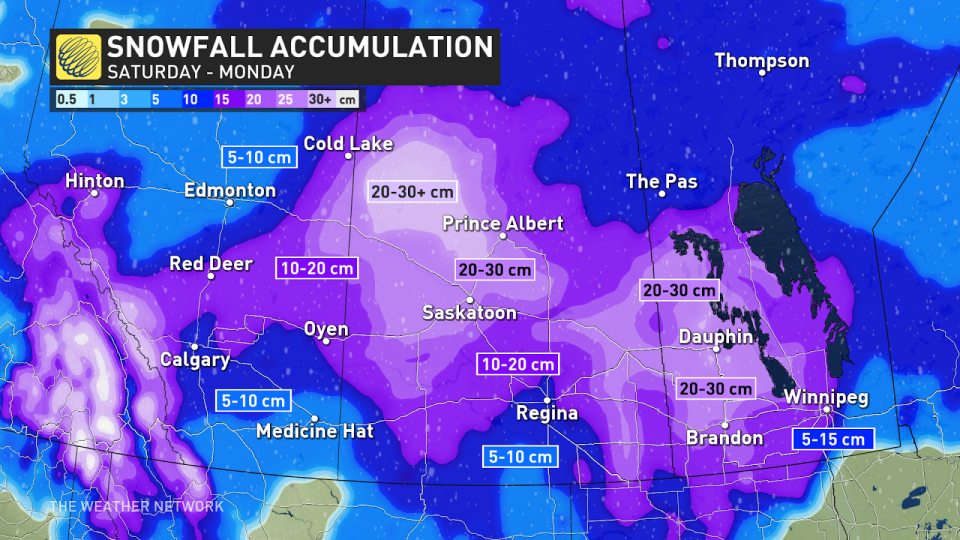
Those in Alberta can expect to see anywhere from 5-10 cm or closer to 10-20 cm of snow. Winds over 50 km/h are expected alongside the snow, creating hazardous driving conditions and reduced visibility.
The Trans Canada highway will not be as impacted by this system as it was in Calgary on Thursday.
Heavy snowfall and a temperature plunge were to blame for multiple traffic snarls throughout the afternoon rush hour. CBC reported that a multi-vehicle collision brought traffic to a standstill at Highway 40 on Stoney Nakoda First Nation.
SEE ALSO: Expect a turbulent March across Canada as the seasons duke it out
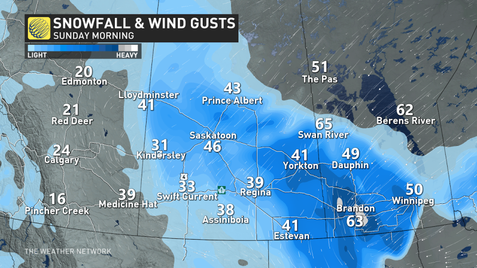
While the snowfall will ease Sunday for Alberta, those in Manitoba will start to see snowfall accumulate on Sunday morning, with heavy snowfall continuing to fall throughout the day.
The snowfall will be at its heaviest throughout Sunday as the system's strengthen and moisture hit its peak. Blizzard-like conditions are possible for folks in Saskatchewan and southwestern Manitoba. The Yellowhead Highway will see the largest impacts as blowing snow and high winds could bring traffic to a standstill.
Take caution if you head out on the highways and leave yourself extra time.
The snow will be on the wetter in Manitoba as warmer temperatures nose their way into the region.
RELATED: Why March is particularly dangerous when it comes to avalanches
One area of uncertainty for this system is Winnipeg. The city has the potential to see either significant snowfall or freezing precipitation as the warmer temperatures flip flop between cold and above freezing.
Winnipeg is at risk of seeing ice pellets on Sunday, which would drastically reduce snowfall totals.
Looking ahead, frigid temperatures are likely through the middle of next week, but temperatures will rebound to close to seasonal late in the week.
WATCH: Pileup on Trans-Canada caused by zero-visibility snowstorm
Keep checking The Weather Network for the latest forecast updates for the Prairies

