Transitioning into spring will bring abrupt temperature shift in Alberta

A decaying ridge will provide warmth to finish the weekend in Alberta, but will be quickly followed by an extreme temperature plunge and heavy snowfall this week as the province makes the switch into the official start of spring.
DON’T MISS: Warmest winter ever: Canada's record season reaches new heights
There is the chance Edmonton and Calgary could hit 16°C and 17°C on Sunday, respectively, unusually mild daytime highs for this time of the year. In fact, it could set a record for the warmest temperature this early in the year for Edmonton airport. Records will be challenged in many areas Sunday and Monday.
However, what goes up must come down, and that definitely applies to temperatures. With an impending, sharp cooldown expected, snowfall will return to the province.
Substantial snows and major travel impacts are possible across parts of the province through the latter half of the week, so plan ahead and keep the snow-clearing equipment and winter clothing nearby.
Sunday and Monday: Record warmth in spots
St. Patrick’s Day will feature impressive warmth across Alberta as temperatures soar far above seasonal for the middle of March.
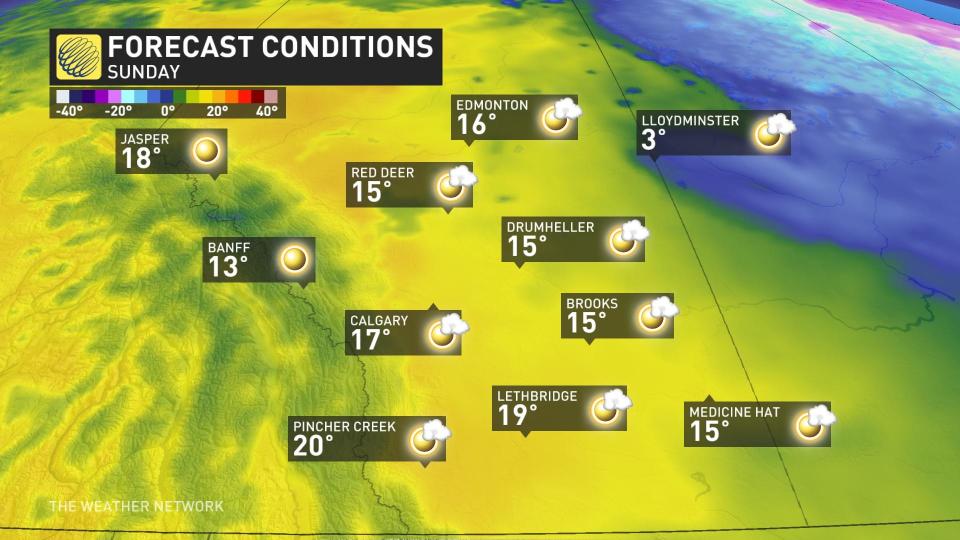
Daytime highs on Sunday will easily climb into the mid- to upper-teens throughout the province, with 17°C in the forecast for Calgary and 16°C for Edmonton.
This would be the warmest reading we’ve ever seen this early in the year at Edmonton airport. Sunday’s predicted high of 16°C would easily surpass the existing record for warmest temperature so early in the year, a 14.4°C reading achieved on March 8, 1988.
What's also notable is that the high temperatures aren’t just confined to lower elevations. Jasper is forecast to exceed 18°C on Sunday once again, some of the earliest warmth recorded in the upper teens.
Grande Prairie, meanwhile, has a forecast high of 22°C, an approximate, astonishing 20 degrees above average for this time of year.
Nighttime lows are unseasonably warm, as well. Edmonton’s overnight low on Sunday will be warmer than the city’s typical daytime high for this time of year.
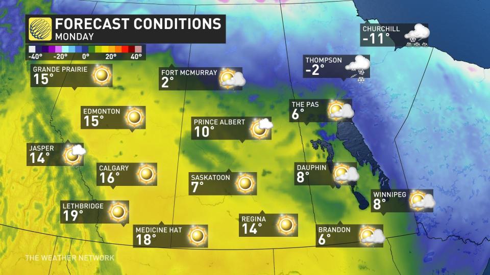
Our warmth will continue into the beginning of the new work week, with double-digit high temperatures likely for much of the province on Monday.
Although daytime highs aren’t expected to be quite as warm on Monday, daily records will still be challenged. The warmth also spreads across the remainder of the Prairie provinces.
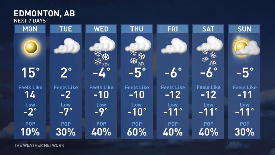
And then the cold front hits.
Tuesday and beyond: A brutal mid-March reality check
Things will change in a hurry on Tuesday as a disturbance moving out of the northern Prairies gradually replaces the ridge that brought our weekend warmth.
This pattern flip will send cold air spilling across central Alberta beginning on Tuesday, with temperatures closer to seasonal there, but remaining above normal across extreme southern sections of the province.
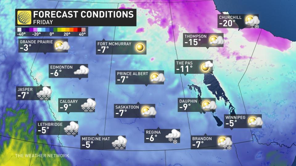
Monday’s high of 15°C will fall on Tuesday to a high of just 2°C for Edmonton, and then highs will drop below freezing into next weekend.
Tuesday night will see the cold air surges south all across the Prairies, lurching the region back into temperatures more reminiscent of winter.
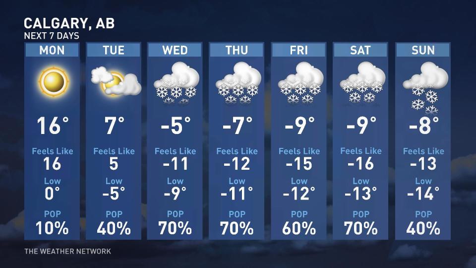
Warmer air will hang on just a day longer down the road toward Calgary, where double-digit temperatures are likely again Tuesday afternoon. The cold air will win out overnight, though, and we’ll see much colder air overspread the rest of Alberta by the middle of the week.
MUST SEE: Historic El Niño has weakened, but its impacts hang on
Calgary’s high of 7°C on Tuesday will seem like a distant memory by Wednesday, when snow will accompany a brisk daytime reading of just -5°C. Yes, that’s a minus sign next to the day’s high.
Cold, northeasterly winds running against the mountains will bring widespread, upsloping snow through the latter half of the week.
Periods of snow will develop across the region by Wednesday. That will be the result of dense, cold air rising along the foothills and the Rocky Mountains –– such an incredible pattern for the drought-striken region.
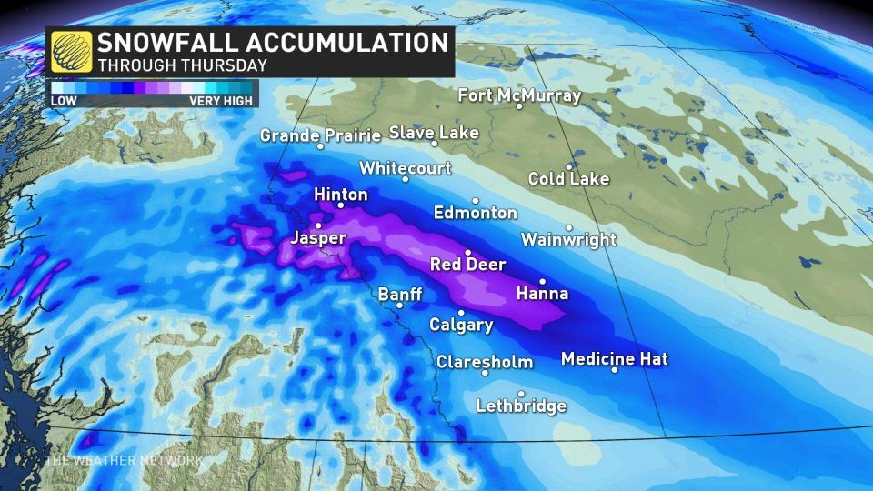
Some areas could see substantial snowfall totals with major travel impacts.
By next weekend, more than 30 cm will have likely have accumulated across southwestern Alberta –– some of the greatest snowfall accumulations experienced over the past 6 months.
Be sure to check back over the next couple of days as forecasters monitor this pattern flip and the risk for disruptive snows.
Header image courtesy of Getty Images/Vera Petrunina/1191394418-170667a.
Stay with The Weather Network for all the latest on your forecast across Alberta.

