Severe Weather Awareness Week: Outdoor Weather Safety

Your Ready Nation Ambassador weather team, StormTracker 59, is once again participating in a week-long Severe Weather Awareness event hosted by the National Weather Service – Charleston. During this week long special we hope to help in being prepared for severe weather. Something we see year long, every year here in our region.

For Friday, March 22nd outdoor recreational & vacation impacts from severe weather:


Outdoor Weather Safety Tips
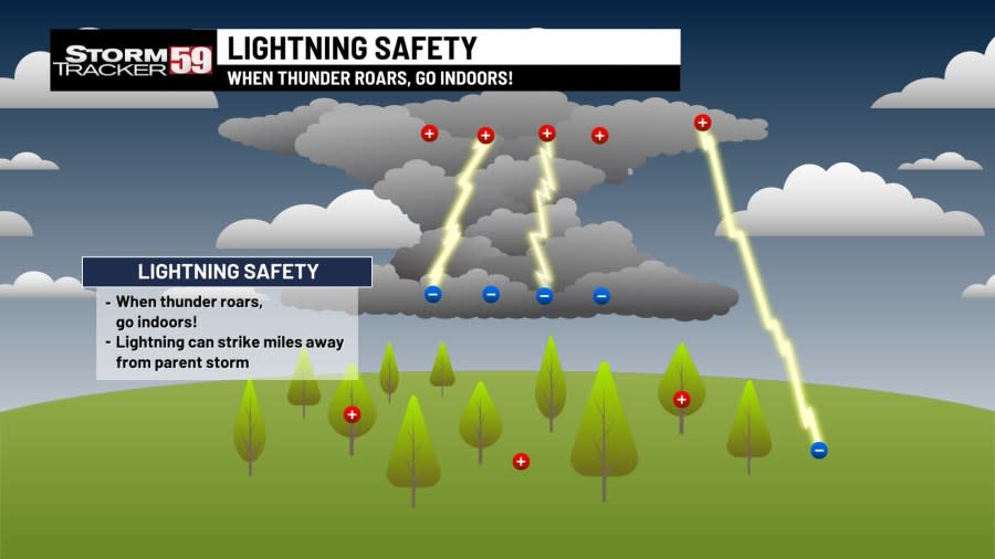
If you are caught outside during a thunderstorm, don’t stand near a natural lightning rod, such as a tree, a telephone pole, or flag pole. Head indoors if possible. Remember, when thunder roars, head indoors!
If a thunderstorm approaches when you are swimming or near water, get out of the water!
During an electrical storm, stay away from appliances, heating ducts, radiators and plumbing. Unplug major appliances.
When planning on being outside for extended periods of time, check the forecast and have a way to receive pertinent weather information, such as watches and warnings for the area you plan to enjoy your outdoor festivities.
Stay safe in a shelter until at least 30 minutes after you hear the last sound of thunder. When you hear thunder, move immediately to a safe shelter.
When severe weather strikes, head to your ‘safe place’ – if you have a house with a basement, the basement is your safest option because it is located downstairs. If you don’t have a basement, head to the most interior room with as little windows as possible.
Have a helmet and protective footwear, like boots, ready at your safe place.
Be sure that your emergency kit is updated and ready for you to use!
Never drive through flooded area, especially at night when it is harder to determine water depth. Remember the phrase “turn around, don’t drown!”
Be familiar with land surrounding you and be prepared to head for higher ground if necessary.
Never walk or wade in floodwaters. The water will oftentimes move very swiftly. It only takes six inches of swift moving water to sweep a person off their feet!
Flood tips for 2024 Flood Resiliency Week in West Virginia
Make sure you have multiple ways of receiving warnings, whether it be with through the StormTracker 59 app, another WEA (Wireless Emergency Alert), weather radio or another method of receiving warnings.

If you plan on going for an extended trip with a lot of driving involved, have an emergency kit ready in case of an emergency. The same items you’d put in your home emergency kit can be utilized for you car emergency kit. These items include but are not limited to:
Water (One gallon per person per day for several days, for drinking and sanitation)
Food (enough non-perishable food to last several days)
NOAA weather radio
Flashlight
First aid kit
Batteries
Whistle or air horn (to signal for help)
Mask (such as a dust mask to help filter contaminated air)
Duct tape (in case of shelter-in-place)
Boots
Helmet (protects your head in case of extreme weather, such as a tornado)
Moist towelettes (for personal sanitation)
Wrench or pliers to turn off utilities
Manual can opener
Local maps
Cell phone chargers
Having an Emergency Kit for holiday travel might just save your life

One of the greatest resources the weather community has is the eyes and ears of our community, you. Local Storm Reports are a vital tool to help meteorologists, emergency management officials, the National Weather Service, and other to know exactly what is happening in the field.

Our National Weather Radar grid is exceptional at gathering all kinds of data. Rain or snow, wind speed and direction, tornado detection, hail sizes in the clouds. But all of this is only by what it can see. In a mountainous terrain like ours, some areas are blocked from view. For these areas, volunteers on the ground become a vital part of warning issuance discussions, updates to current condition information for apps, and so much more.

With many ways to get weather information, several app are automated pulling data only from one source. If that source doesn’t see a storm rolling in, it can give you the impression all is safe. An observer sending in a report could save another person in your community from being caught off guard.

The National Weather Service offers free classes for folks to take to become certified Skywarn Storm Spotters to know what to report, when to report, and who to report too. And our StormTracker 59 team is always available on social media or email: weather@wvnstv.com

The StormTracker 59 team has you covered to help keep you and your family safe when the threat for severe weather is possible! There are multiple ways of staying up to date with us on the latest warnings for our region that would indicate this potential threat:
On air on WVNS-TV 59 on CBS at 5 AM, 6 AM, 12 PM, 5 PM, 6 PM and 11 PM Monday through Friday and 6 PM and 11 PM on the weekends.
On air on WVNS-TV 59 on Fox at 7AM Monday through Friday, and everyday at 10 PM.
Online on our website here, where you can see the latest watches, warnings, forecast discussions, videos, current data and so much more!
The StormTracker 59 mobile app, free on the Apple and Google Play.
The StormTracker 59 Facebook page and Twitter page.
After the storm, when safe to do so, your voice, photos, and video can be some of the best resources your local, state, and federal meteorologists have in determining what caused storm damage. It can even be the only look we have at what is going on at ground level when severe weather strikes. For StormTracker 59 we make sharing these easy via social media, email at weather@wvnstv.com, or our community photo album on our website. Weather Together is free and easy to share photos with us and your community. Try it out for yourself here.

For the latest news, weather, sports, and streaming video, head to WVNS.

