Summit, Stark, Portage counties and others under tornado watch through midnight
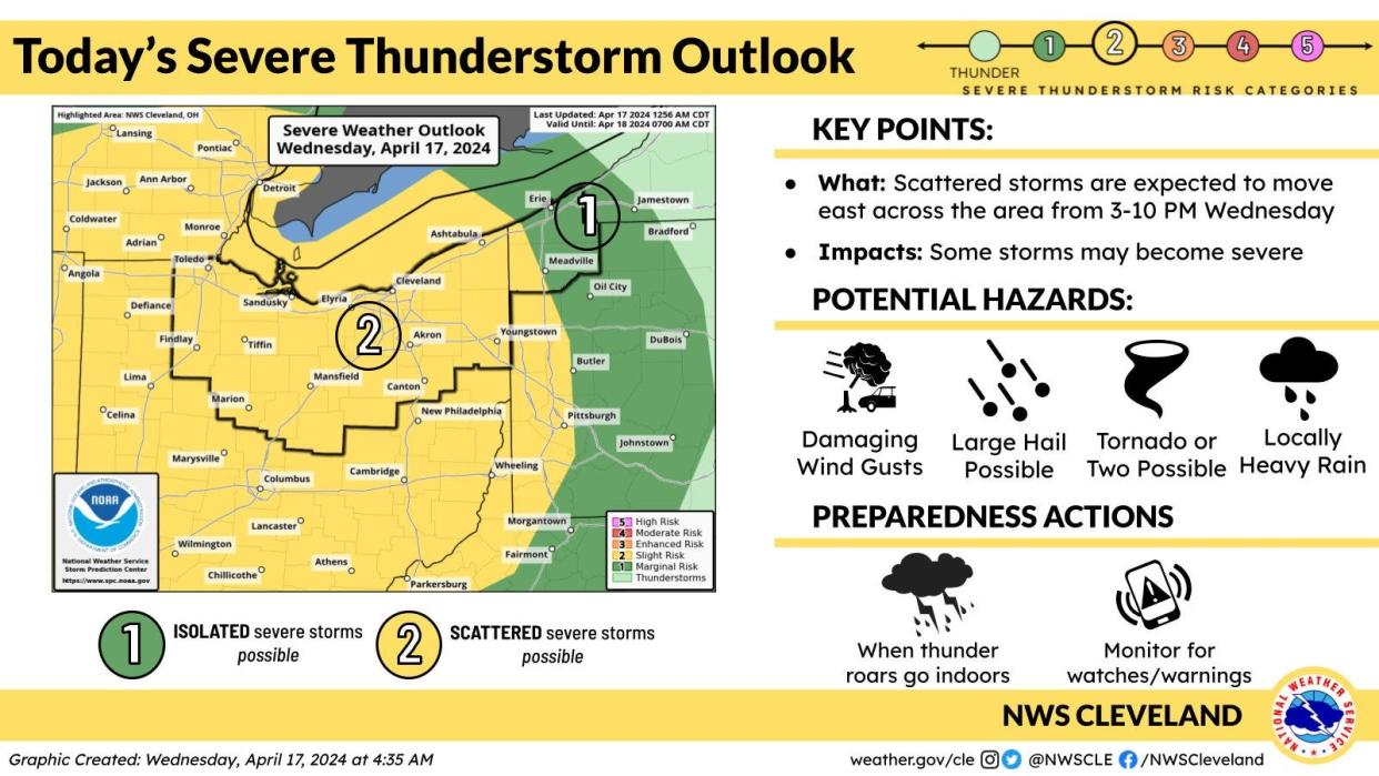
Severe storms and even isolated tornadoes are possible across northern Ohio on Wednesday.
The National Weather Service says thunderstorms − some severe − are expected to develop across Indiana this afternoon and move east into Ohio.
The storms could bring ping pong sized hail, damaging wind gusts up to 70 miles per hour, torrential rain and even "a couple tornadoes" in northern Ohio.
A tornado watch has been issued through midnight for several counties including Summit, Portage and Stark counties.
Things will dry out Thursday before rain returns to the region on Friday.
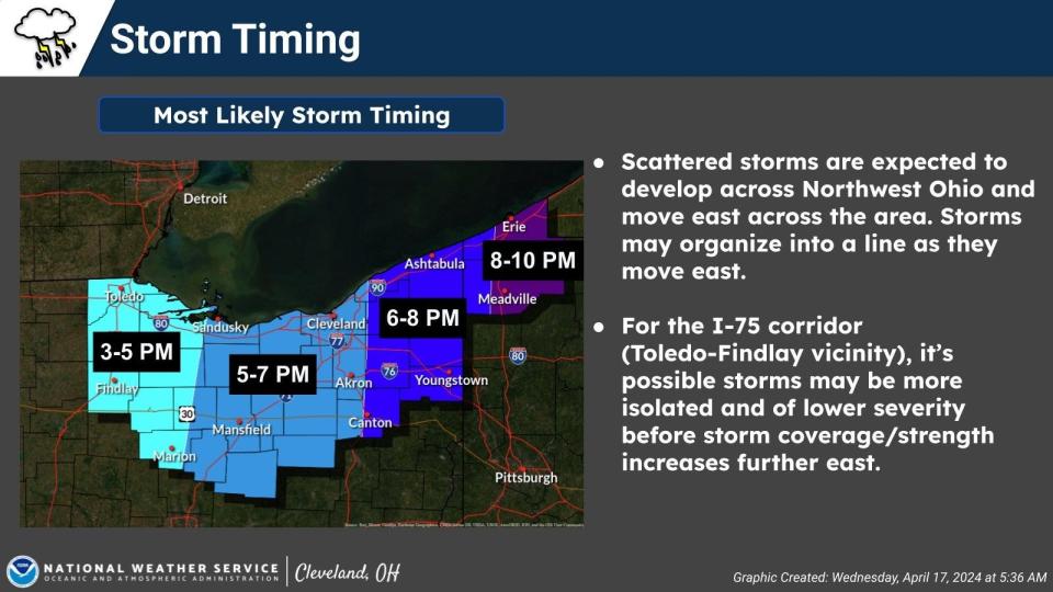
What's the timing of Wednesday's storms?
The weather service says the storms are expected to reach western Ohio between 3 p.m. and 5 p.m.
The line of storms could impact northern Ohio cities including Cleveland, Akron and Mansfield between 5 and 7 p.m.
The storms are expected to strengthen as they move across the state.
What's the forecast?
Wednesday: Showers and thunderstorms likely before 2 p.m., then showers and thunderstorms likely after 5 p.m. Cloudy, then gradually becoming mostly sunny, with a high near 75. South wind 13 to 17 mph. Chance of precipitation is 60%. New rainfall amounts between a tenth and quarter of an inch, except higher amounts possible in thunderstorms.
Wednesday night: Showers and thunderstorms before 9 p.m., then a slight chance of showers between 9 p.m. and 11 p.m. Low around 53. West wind 9 to 11 mph. Chance of precipitation is 80%. New precipitation amounts of less than a tenth of an inch, except higher amounts possible in thunderstorms.
Thursday: Partly sunny, with a high near 68. West wind 7 to 9 mph.
Thursday night: A slight chance of showers, then showers likely and possibly a thunderstorm after 2 a.m. Increasing clouds, with a low around 53. Southeast wind 5 to 13 mph. Chance of precipitation is 70%. New rainfall amounts between a tenth and quarter of an inch, except higher amounts possible in thunderstorms.
Friday: Showers and thunderstorms likely before 11 a.m., then a chance of showers between 11 a.m. and 2 p.m. Mostly cloudy, with a high near 63. South wind 11 to 17 mph becoming northwest in the afternoon. Chance of precipitation is 60%. New precipitation amounts between a tenth and quarter of an inch, except higher amounts possible in thunderstorms.
Friday Night: Mostly cloudy, with a low around 41.
Saturday: Mostly sunny, with a high near 53. Breezy.
Saturday night: Partly cloudy, with a low around 35.
Sunday: Mostly sunny, with a high near 54.
Sunday night: Mostly clear, with a low around 36.
Monday: Mostly sunny, with a high near 62.
Monday night: Partly cloudy, with a low around 43.
Tuesday: A chance of showers. Mostly cloudy, with a high near 61. Chance of precipitation is 50%.
Check Akron weather hourly
Need to know weather conditions by the hour? Make sure to check out our weather page here.
This article originally appeared on Akron Beacon Journal: Tornado watch for Summit, Stark and Portage counties through midnight

