Severe storms to take aim from Missouri to Alabama, Georgia into Thursday night
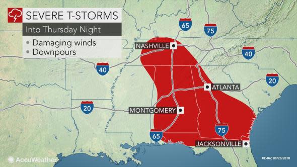
A narrow corridor from the mid-Mississippi Valley to the interior Southeast will be at risk for severe thunderstorms into Thursday night.
Locally severe thunderstorms rattled and drenched communities in north-central Missouri and eastern Tennessee, northern Georgia and the western parts of the Carolinas during Thursday morning and early Thursday afternoon.
Over 175,000 electric customers were without power as the storms advanced southward across Alabama on Thursday afternoon.
A tornado-warned thunderstorm moved through the St. Louis area on Thursday evening; however, no tornado has been confirmed. The same storm also brought winds over 55 mph, leading to thousands of power outages.
High wind, heavy rain send trampoline flying in Chapel Hill, Tenn. News 2 #WeatherAuthority pic.twitter.com/XCfpIZE4SF
— WKRN (@WKRN) June 28, 2018
Damage in Vincent (Shelby County)... on CR 466... photo from Samecca McCrimon pic.twitter.com/NQ0K29P7yy
— James Spann (@spann) June 28, 2018
The swath of storms will change its orientation somewhat, but will continue to affect the same general part of the nation as recent days. During Thursday night, the storms will cruise along a north to south path, rather than northwest to southeast.
"Areas from middle Tennessee to Alabama, western Georgia and northern Florida will be at risk for locally damaging storms into Thursday night," according to AccuWeather Senior Meteorologist Alex Sosnowski.
"Farther to the north, a new batch of heavy, gusty and locally severe thunderstorms move out of southeastern Iowa and into part of western and southern Illinois and areas of Missouri along the Mississippi River," Sosnowski said.
"Late Thursday night, this batch of storms may return downpours to parts of western Kentucky and northwestern Tennessee."
Damaging winds, hail and downpours that can drop a quick inch or more of rain are expected to be the most widespread impacts from the storms.
Even in areas outside of the main corridor of severe storms will be at risk for localized torrential downpours, flash flooding and gusty winds.
Due to localized flooding, there are various closures throughout the park, including the Elkmont campground. Drive safely, and for more information on road closures, call the road closures hotline 865-436-1200 #2 #2 or text "follow smokiesroadsnps" to 40404. pic.twitter.com/iCx9nd9r1z
— GreatSmokyNPS (@GreatSmokyNPS) June 28, 2018
Any area that has been hit with repeating downpours in recent days can quickly experiencing flooding. Streams are running high from the southern Appalachians to the middle part of the Mississippi Valley.
In addition, trees that have been weakened from the rain and wind of prior storms this week will be more susceptible to falling. Extensive power outages are likely.
People outside or on the roadway should stay up to date on the latest severe weather alerts, as the storms may blow through quickly with little notice.
Towering, darkening clouds and sudden gusts of wind can be signs that a storm is approaching and that shelter should be sought immediately.
The risk of organized severe weather over the Southeast will ease somewhat on Friday, though a few storms across the Deep South could turn heavy and gusty on the local level.
