Before and after: See destruction of Michigan flooding in satellite images
DETROIT – Satellite images — taken from space nearly a year apart from each other — show just how devastating the flood damage is in Midland County.
The record flooding this week destroyed homes, cars, roads, bridges and other property; damaged the sewer system, and forced 10,000 people to evacuate the area along the river, leaving many homeless and without electricity.
The natural-color images from Landsat 8, an American Earth observation satellite, depict the two mid-Michigan dams — Edenville and Sanford — that failed and the Tittabawassee River.
The Tittabawassee River hit a historic high Wednesday morning, rising above its previous record in 1986, and reaching 34.6 feet. Major flood stage is 28 feet.
A number of homes in Midland were damaged, but no injuries or fatalities were reported. A spokeswoman for Midland said Friday that residents were cleared to return home if they can safely do so.
The dams are both owned by Boyce Hydro Power.
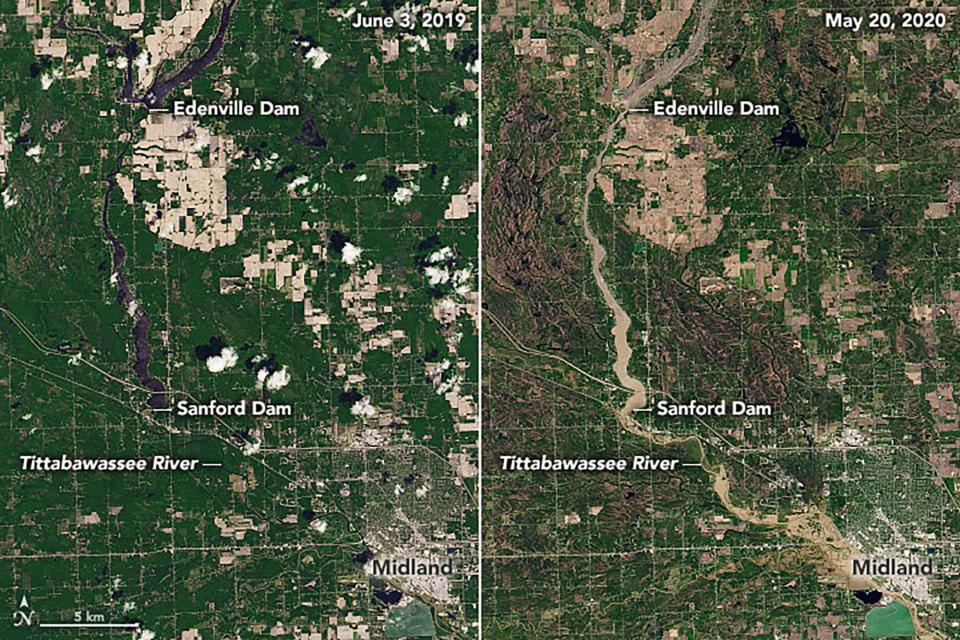
News reports say that at one point, nearly 374,000 gallons — about half the volume of an Olympic-sized swimming pool — per second were rushing through the Edenville Dam.
At the same time, the dam breach drained Wixom Lake, the reservoir. Wixom Lake looked like a giant beach with a small river running through it.
It's unclear whether the Sanford Dam also breached but it also failed to hold floodwaters back.
Gov. Gretchen Whitmer, who visited and flew over the area Wednesday, acknowledged that Michiganders are living through tough times, but need to remain vigilant — and helpful — especially during the upcoming Memorial Day weekend.
"If you know someone who has been impacted, please reach out," she said, referring especially to the mid-Michigan residents whose lives had been turned upside down. "This is truly a crisis in the middle of a crisis."
President Donald Trump signed an emergency declaration Thursday authorizing the Department of Homeland Security and the Federal Emergency Management Agency to coordinate disaster relief efforts.
In Spaulding Township near the Tittabawassee River, about a dozen people have evacuated, Fire Chief Tom Fortier told the Associated Press on Friday morning.
Fields and roads were under several feet of water, resembling wide, shallow lakes. Water stood 2 to 3 feet deep in some houses where the owners decided to stick out the flooding, Fortier said.
Contributing: Associated Press
This article originally appeared on Detroit Free Press: Michigan flooding: See destruction left behind after two dams failed

