Scattered storm chances to continue through holiday weekend
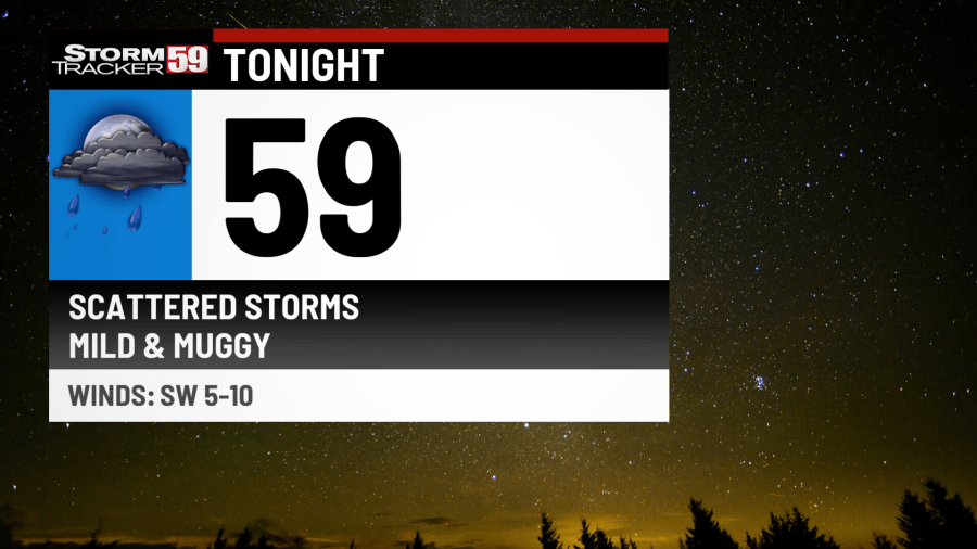
Tonight provides increasing chances for scattered showers and thunderstorms, as a cold front approaches from our west. Some downpours could produce locally heavy rainfall. The Storm Prediction Center has placed our region in a level one out of five risk for severe weather tonight, primarily for the risk of damaging wind gusts. It’s a mild and muggy night on the way overall, with lows in the low 60s.
Thursday features scattered showers and thunderstorms with our cold front crossing. It won’t rain all the time, but a few storms could produce brief heavy rainfall with a gloomy day on the way under mostly cloudy skies. Expect wet roadways, especially for the evening commute. With the clouds and storms around, high temperatures will dip back into the mid 70s. The Storm Prediction Center has once again placed our region under a level one out of five risk for severe weather for damaging wind gusts and the potential for hail in a couple of thunderstorms. The best chance for thunderstorms will be during the early to middle afternoon.
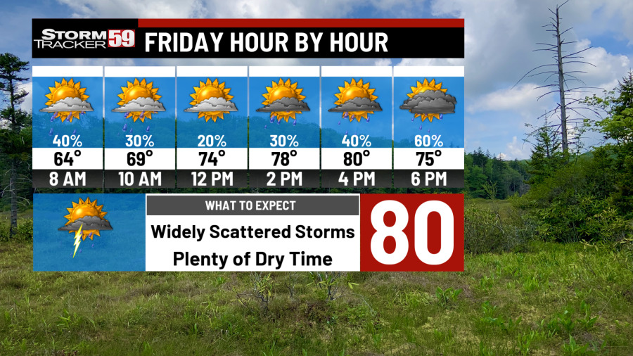
Friday sees continued chances for rain and storms, as our cold front stalls nearby. With the front just to our south and a low pressure system riding along that front, more chances for storms will result with high temperatures in the mid to upper 70s.
That wave of low pressure will move in during the afternoon, which means the morning should be pretty dry, however our chances for storms will increase as the afternoon progresses. There will be more breaks in the rain activity than on Thursday, however, the Weather Prediction Center has placed our region in a level one out of four risk for flooding due to the slow-moving nature of storms that do develop.
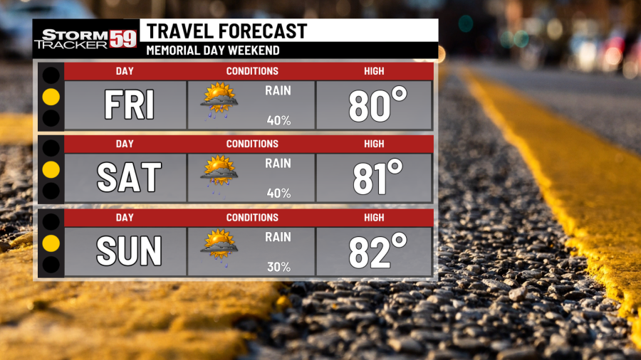
Saturday as we kick off Memorial Day weekend begins on an unsettled note and unfortunately, this pattern looks to stick around. Scattered showers and storms will be around, though not widespread in coverage, as another cold front slides toward the area and then stalls. High temperatures will be in the upper 70s to right around 80 degrees. The theme for the Memorial Day weekend holiday will be scattered downpours, but there will be plenty of breaks between scattered showers and storms.
Sunday keeps the risk for a few scattered showers and storms, with a low pressure system moving up into the Great Lakes and a warm front sliding through our region. We’ll watch that setup closely for the potential for a couple of strong storms. Overall, it’s still a day where scattered storms will be expected with breaks and It’s a summer-like day on the way with our stalled front slightly lifting north as a warm front, which should enable high temperatures to jump back up to near 80.
Top products for hosting a Memorial Day party
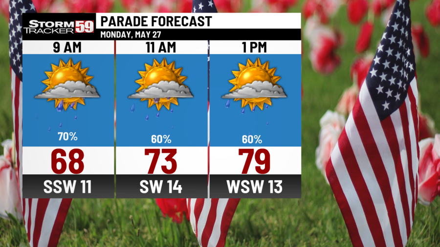
Memorial Day provides more showers and thunderstorms, as Sunday’s low pressure system heads north and drags a cold front through the region. At this point, the front looks to cross during the morning, which would limit severe weather potential but still provide scattered showers and a few rumbles of thunder. However, we’ll watch the timing of this front closely, as a later day front crossing would invite the potential for strong storms. We’ll see high temperatures in the upper 70s.
Tuesday brings forth a few showers in the morning with a northwest flow but we should see drying taking place by the afternoon. You’ll notice much cooler conditions, as high temperatures only reach the low 70s.
NOAA predicts very active hurricane season, issues highest-ever May forecast
Wednesday continues the risk for an isolated shower but many of us look to be dry as high pressure noses in from Canada. With a northerly flow in place, temperatures will remain cooler with highs in the low 70s.
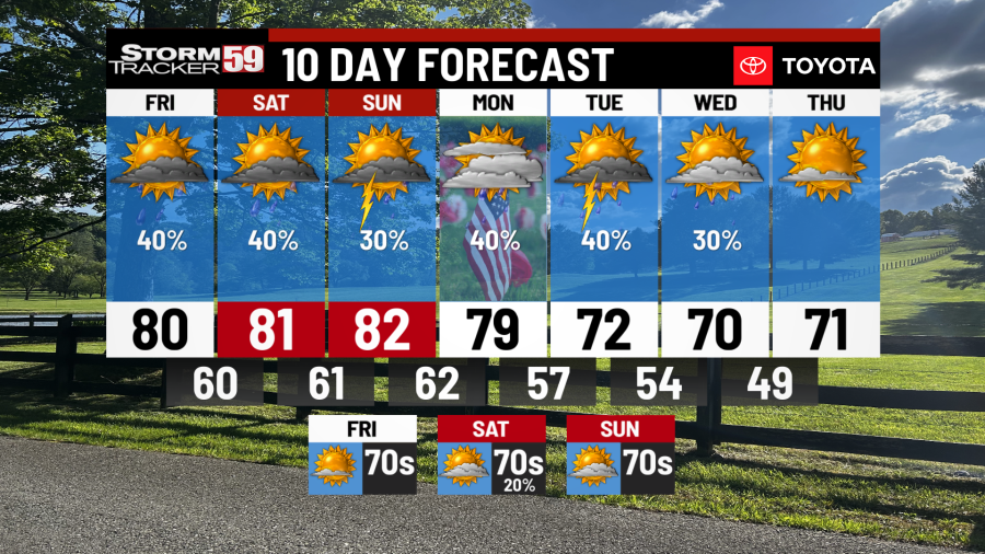
Looking ahead, our setup finally relaxes a bit, as high pressure noses in from Canada. That means sunshine will return for Thursday, Friday and Saturday. With high pressure to our north and west on Thursday, a cool air flow will result in highs struggling to reach 70 degrees. However, high pressure will move overhead and hang around Friday into Saturday, which will allow temperatures to jump back up into the mid 70s.
TONIGHT
Scattered showers and storms. Lows in the low 60s.
THURSDAY
Scattered showers and storms likely. Highs in the mid 70s.
FRIDAY
Scattered storms. Highs in the upper 70s.
SATURDAY
Scattered showers and storms. Highs near 80.
SUNDAY
More scattered thunderstorms. Highs in the low 80s.
MEMORIAL DAY
Scattered showers and storm chances continue. Highs in the upper 70s.
TUESDAY
AM showers. PM sunshine. Cooler. Highs in the low 70s.
WEDNESDAY
Isolated showers. Highs in the low 70s.
THURSDAY
Mostly sunny. Highs in the low to mid 70s.
FRIDAY
Mostly sunny. Highs in the mid 70s.
SATURDAY
Mostly sunny. Highs in the mid 70s.
Copyright 2024 Nexstar Media, Inc. All rights reserved. This material may not be published, broadcast, rewritten, or redistributed.
For the latest news, weather, sports, and streaming video, head to WVNS.

