Soaking rain, milder air to move into eastern US at late week
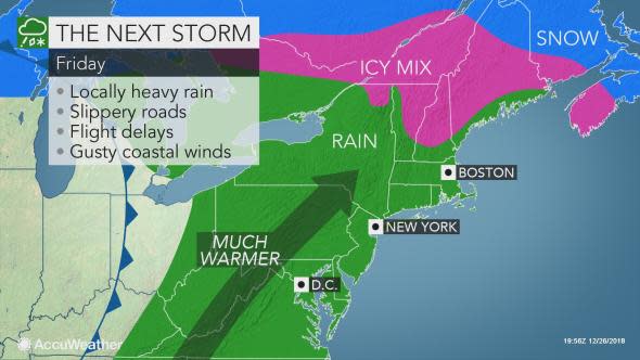
The stretch of tranquil weather in the eastern United States will come to end as a storm moves in with drenching rain, milder air and a bit of a wintry mix from Thursday to Friday night. The storm will renew the risk of urban, small stream and even river flooding in some cases.
People with travel plans through Wednesday night in the Southeast and Thursday in the Northeast should have few weather-related travel disruptions as mainly dry weather continues.
Thursday will feature more dry, sunny weather for the Northeast, but it will be a frigid day in northern New England as fresh cold spills in and keeps highs to the teens and lower 20s F.
The storm system poised to unleash heavy snow and severe weather over the central U.S. will begin to spread rain into the Southeastern states on Thursday and then farther to the northeast during Thursday night and Friday morning.

The major airport hubs of Atlanta; Charlotte, North Carolina; Washington, D.C.; New York City and Boston may also be impacted by delays due to rain, a low cloud ceiling and/or a gusty wind at times.
Commuters and people getting a head start on their New Year's Eve destinations can be slowed by rain on stretches of interstates 10, 20, 40, 70, 77, 80, 81, 85, 90 and 95.
Before venturing out, motorists should ensure windshield wipers are in good working order and tire tread is not too worn, which can further heighten the risk of vehicles hydroplaning at highway speeds.
A general 0.5-1.5 inches of rain can fall from the Ohio Valley to the mid-Atlantic spanning Thursday night to Friday evening.
While these amounts are not excessive, rises can occur on small streams and creeks, given how saturated the ground is from excessive rainfall in recent weeks and months.
"The soaking rain could introduce more flooding issues to the area," according to AccuWeather Lead Long-Range Meteorologist Paul Pastelok.
Many small streams and the larger rivers are running near bank full in the Northeast and some remain out of their banks in the Southeast.
The greatest risk for heavy rain and flooding may extend across the South, with any flooding issues in the Northeast being much more isolated.
Rainfall on the order of 1-3 inches with locally higher amounts can occur over the southern Appalachians and Piedmont areas to the central Gulf coast.
Much of this rain may fall during a 12 hour period. A mere 3 inches of rain in 12 hours is enough to lead to new flooding along small streams and to cause some rivers to rise by several feet once again.
The rain will come with a surge of milder air, with Friday's highs expected to be in the 50s F from Buffalo, New York, to Boston, and 60s F from Washington, D.C., to Philadelphia.
So while people will not be able to step outside without a rain jacket or umbrella, they can get by with fewer layers than earlier in the week.
In some areas of the Northeast, however, lingering cold air will put up a fight.
In parts of upstate New York and New England, precipitation can start as a bit of sleet or freezing rain on late Thursday night or Friday morning, according to AccuWeather Senior Meteorologist Carl Babinski. This includes in Albany, New York, Portland, Maine, and the northwestern suburbs of Boston.
This wintry mix can create a slick layer on untreated roads and sidewalks, before precipitation switches over to plain rain.
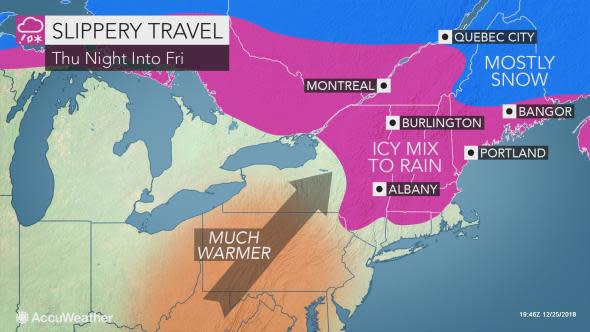
In northern New England, the mild conditions may never fully break free, which can allow for a lengthier period of snow, ice and slick travel in Caribou, Maine.
Download the free AccuWeather app to see when and what type of precipitation will fall in your area.
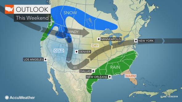
Conditions will turn cooler, but drier for the start of the weekend.
However, AccuWeather meteorologists are closely monitoring the potential for lingering moisture in the South to surge back northward late in the weekend.
A period of snow may sweep across a part of the Northeast around Sunday, but only if a southern storm travels far enough to the north in the chillier air.
We are also watching New Year's Eve or New Year's Day for the potential for snow and ice in part of the Northeast, Pastelok stated.
Both of these storms may bring more drenching rain to the Southeast and may bring at least one dose of the same to part of the Northeast. As a result rivers and streams are likely to remain high in the northeast and above flood stage in the Southeast.
Continue to check back with AccuWeather for updates on the latest forecast for the New Year's holiday.
