School, road closures as winter storm impacts spill into Monday on the Prairies
We’ve made it to the final act of the Prairies’ most impactful winter storm of the season. Heavy snow and gusty winds will continue whipping through portions of Saskatchewan and Manitoba into Monday morning before finally tapering off through the day.
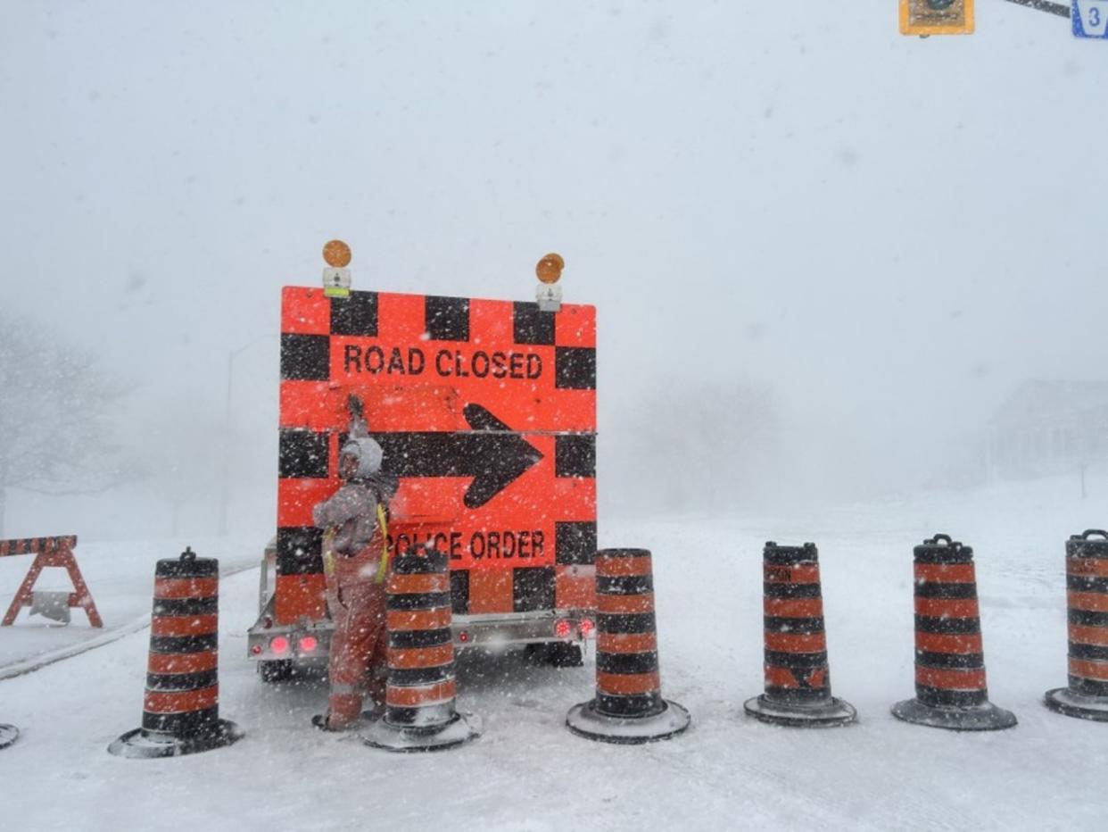
In all, between 20-40 cm of snow was forecast in the hardest hit areas through Monday, with strong wind gusts and whiteout conditions leading to several road closures throughout southern sections of Saskatchewan and Manitoba late Sunday.
Saskatoon activated its Roadways Emergency Response Plan on Sunday, which includes snow grading on all streets--including local streets--that are not typically graded. Several schools in southern sections of the province opted to close their doors Monday morning, with over 15 school divisions closed in Manitoba, as well.
MUST SEE: Expect a turbulent March across Canada as the seasons duke it out
Snow, and blowing snow warnings still covered parts of Saskatchewan and Manitoba early Monday, with the threat for more difficult driving conditions and limited visibilities. Drivers are urged to adapt to the changing conditions, and to postpone non-essential travel until things improve.
More difficult travel, closures before improvements later Monday
The persistent, wind-whipped snows forced officials to close roads across the region on Sunday due to dangerous driving conditions. A number of roads and highways remained closed in both Saskatchewan and Manitoba on Monday.
Be sure to stay on top of road conditions across the region before heading out.
A low-pressure system trekking across the Prairies reached its peak strength on Sunday as the storm spun over the eastern half of the Prairies.
Bands of snow near the heart of the storm grew so intense Sunday afternoon that numerous lightning strikes occurred over southwestern Manitoba between Brandon and Portage la Prairie.
Hail reported in Somerset, MB. Approximate time 2:25pm CST. Permission to post photo and video. #mbstorm #mbwx pic.twitter.com/gdu7CfGjA6
Hail reported in Somerset, MB. Approximate time 2:25pm CST. Permission to post photo and video. Suzanne Pothe on Twitter: "Hail reported in Somerset, MB. Approximate time 2:25pm CST. Permission to post photo and video. #mbstorm #mbwx pic.twitter.com/gdu7CfGjA6 / Twitter" Suzanne Pothe on Twitter: "Hail reported in Somerset, MB. Approximate time 2:25pm CST. Permission to post photo and video. #mbstorm #mbwx pic.twitter.com/gdu7CfGjA6 / Twitter" Suzanne Pothe on Twitter: "Hail reported in Somerset, MB. Approximate time 2:25pm CST. Permission to post photo and video. #mbstorm #mbwx pic.twitter.com/gdu7CfGjA6 / Twitter"
— Suzanne Pothe (@Spothe) Suzanne Pothe on Twitter: "Hail reported in Somerset, MB. Approximate time 2:25pm CST. Permission to post photo and video. #mbstorm #mbwx pic.twitter.com/gdu7CfGjA6 / Twitter"
A full-blown thunderstorm even produced a period of hail near Somerset, Manitoba—no small feat when temperatures are hovering around the freezing mark.
Warmer temperatures around Winnipeg led to a period of freezing rain on Sunday before transitioning over to snow as colder temperatures wrapped into the area to end the storm.
Winds still a main hazard
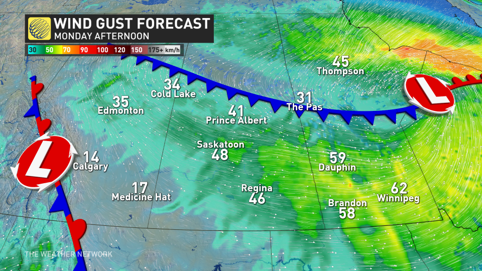
The heaviest snow continues to wind down through Monday morning, but powerful winds will persist, with gusts between 50-70 km/h pummeling eastern Saskatchewan and southern Manitoba.
This will lead to blowing snow and near-zero visibility. The dry and powdery nature of freshly fallen snow will make reduced visibility a hazard even after precipitation ends.
Central and northern Manitoba can expect another 5-10 cm of snow before the snow ends later Monday.
LEARN MORE: How the tropics help produce big springtime snows on the Prairies
If you’re already tired of the snow, fear not. While frigid temperatures will remain locked across the Prairies through the middle of the week, a warm-up is on the horizon heading into next weekend and beyond.
Stay with The Weather Network for all the latest on this snowstorm across the Prairies.

