Severe storm warnings and tornado watches lifted in Cincinnati area as storms move east
Update 8:30 p.m.: The tornado watch has been canceled for portions of eastern Indiana, northern Kentucky, and western Ohio including the Cincinnati and Dayton metro areas. The National Weather Service at Wilmington said the risk for tornadoes and severe storms remains in areas to the east.
Update 8:11 p.m.: In the aftermath of severe storms in Greater Cincinnati on Tuesday, streets are being closed due to high water.
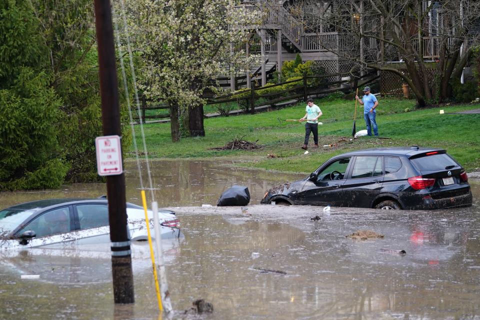
In Cincinnati, those streets include the 1200 block of Gest Street, the 5100 block of Rhode Island Avenue, Reading Road and Liberty Street near the on-ramp and Martin Luther King Drive and Eden Avenue.
West Chester Township is also reporting road closures due to downed power lines and high water, including at Lesourdsville West Chester Road between Tylersville and Hamilton Mason roads, as well as at Fountains Boulevard.
"If you come up on high water, never attempt to drive, swim or walk through it, this could be very dangerous," said Cincinnati Police Lt. Jonathan Cunningham.
Update 7:38 p.m.: The National Weather Service says a confirmed tornado was located over Ripley, Ohio.
The twister was seen on radar with debris in the air, which could be hazardous to those not taking shelter.
A tornado warning remains in effect for parts of Brown and Highland counties and Eastern Kentucky.
Update 7:22 p.m.: As severe storms begin to move east and away from the Cincinnati area, a tornado warning was issued for parts of Brown and Highland counties and Eastern Kentucky.
The warning is in place until 7:45 p.m. and includes Maysville, Kentucky, as well as Ripley, Aberdeen, Lake Lorelei, Fayetteville and Saint Martin in Ohio, according to the National Weather Service.
Severe storm warnings have largely been lifted in Greater Cincinnati but the region remains under a tornado watch until 10 p.m.
Update 6:45 p.m.: A tornado warning in Northern Kentucky appears to have been lifted, but a severe thunderstorm warning is in place until 7:30 p.m. for several Greater Cincinnati counties.
The alert is for portions of Campbell County in Kentucky, as well as Hamilton, Clermont, Brown, Warren, Clinton and Highland counties in Ohio.
A severe thunderstorm was located over Fort Thomas at 6:38 p.m., moving east at 50 mph. Forecasters are warning of 60 mph wind gusts and quarter-size hail.
Areas impacted include Cincinnati, Covington, Norwood, Fort Thomas, Newport, Madeira, Highland Heights, Milford, Bellevue, Deer Park, Dayton, Blanchester, Southgate, Forestville, Amelia, Mount Orab, Mariemont, Wilder, Williamsburg, and Terrace Park.
Update 6:20 p.m.: A tornado warning has been issued until 6:45 p.m. for parts of Northern Kentucky, including the central portions of Boone, Kenton and Campbell counties.
Forecasters say a severe thunderstorm capable of producing a tornado was spotted over Rising Sun moving east at 60 mph.
Hazards include flying debris and damage to mobile homes and other property.
Areas impacted include Covington, Florence, Independence, Erlanger, Edgewood, Alexandria, Elsmere, Highland Heights, Taylor Mill, Fort Wright, Crestview Hills, Rising Sun, Oakbrook, Claryville, Burlington, Union, Wilder, Silver Grove, Cold Spring, and Ryland Heights.
Tornado Warning including Florence KY, Independence KY and Erlanger KY until 6:45 PM EDT pic.twitter.com/SGkwkZIeB9
— NWS Wilmington OH (@NWSILN) April 2, 2024
Update 6:04 p.m.: A severe thunderstorm warning has been issued for parts of Southwest Ohio, Northern Kentucky and Southeast Indiana until 6:45 p.m.
The alert includes Ohio, Dearborn and Switzerland counties in Indiana; Kenton, Campbell and Boone counties in Kentucky and Hamilton, Warren and Clermont counties in Ohio.
The National Weather Service said 60 mph wind gusts and quarter-size hail, with damage to vehicles, trees and power lines possible.
Areas impacted include Cincinnati, Mason, Lebanon, Springboro, Covington, Florence, Independence, Norwood, Erlanger, Fort Thomas, Newport, Madeira, Edgewood, Alexandria, Elsmere, Fort Mitchell, Villa Hills, Highland Heights, Taylor Mill, Bellevue, Fort Wright, Dayton, and Lawrenceburg.
A large portion of Southwestern Ohio, Southeastern Indiana and Northern Kentucky remains under a tornado watch until 10 p.m.
Update 5:50 p.m.: A severe thunderstorm warning is in place until 6:30 p.m. for parts of Greater Cincinnati, including portions of Dearborn County in Indiana and Hamilton and Butler counties in Ohio.
The alert impacts Cincinnati, Forest Park, Sharonville, Blue Ash, Springdale, Reading, Montgomery, Harrison, North College Hill, Madeira, Wyoming, Cheviot, Mount Healthy, Deer Park, Hamilton, Fairfield, Hamilton, Lawrenceburg, Greendale, Bright and Hidden Valley.
The National Weather Service is warning of minor hail damage to vehicles and wind damage to trees and power lines.
Severe Thunderstorm Warning including Fairfield OH, Forest Park OH and Sharonville OH until 6:30 PM EDT pic.twitter.com/b0163OI1rG
— NWS Wilmington OH (@NWSILN) April 2, 2024
Update 5:20 p.m.: Several Greater Cincinnati counties are under a tornado warning until 6 p.m.
The alert impacts Ohio County and parts of Ripley, Dearborn and Switzerland counties in southeast Indiana. The National Weather Service said that radar indicated a "tornado-producing storm" was spotted 10 miles south of Vernon moving east at 55 mph.
A tornado was observed by law enforcement. Forecasters are warning of flying debris, property damage and quarter-size hail.
Update 5:05 p.m.: Parts of southeast Indiana are under a tornado warning.
The weather service has issued a tornado warning for Ripley, Dearborn and Ohio counties in southeast Indiana.
An alert will remain in place for Jennings and Jackson counties until 5:30 p.m. Jennings County is about 75 miles west of Cincinnati. Around 4:53 p.m., a severe thunderstorm capable of producing a tornado was spotted eight miles northwest of Scottsburg traveling at 55 mph.
Forecasters are warning of flying debris, property damage and quarter-size hail.
[507 PM] Severe thunderstorms over southern Indiana are now approaching our area, and confidence has increased that the next 3-4 hours will need to be a time for you to be sure you have ways to receive warnings. Stay weather aware! pic.twitter.com/7g2NwIpB7O
— NWS Wilmington OH (@NWSILN) April 2, 2024
Update 3:45 p.m.: A large portion of Southwestern Ohio, Southeastern Indiana and Northern Kentucky have been placed under a tornado watch until 10 p.m. Here are the counties affected by the watch:
Ohio counties: Adams, Brown, Butler, Clark, Clermont, Clinton, Fayette, Franklin, Greene, Hamilton, Highland, Madison, Miami, Montgomery, Pickaway, Pike, Preble, Ross, Scioto and Warren
Kentucky counties: Adair, Allen, Anderson, Barren, Boone, Bourbon, Boyle, Bracken, Breckenridge, Bullitt, Butler, Campbell, Carroll, Casey, Clark, Clinton, Cumberland, Edmonson, Fayette, Franklin, Gallatin, Garrard, Grant, Grayson, Green, Hancock, Hardin, Harrison, Hart, Henry, Jefferson, Jessamine, Kenton, Larue, Lewis, Lincoln, Logan, Madison, Marion, Mason, Meade, Mercer, Metcalfe, Monroe, Nelson, Nicholas, Ohio, Oldham, Owen, Pendleton, Robertson, Russell, Scott, Shelby, Simpson, Spencer, Taylor, Trimble, Warren, Washington and Woodford.
Indiana counties: Barholomew, Brown, Clark, Crawford, Daviess, Dearborn, Decatur, Dubois, Fayette, Floyd, Franklin, Harrison, Jackson, Jefferson, Jennings, Johnson, Lawrence, Martin, Monroe, Ohio, Orange, Perry, Ripley, Rush, Scott, Shelby, Switzerland, Union, Washington and Wayne.
A tornado watch has been issued for parts of Indiana, Kentucky and Ohio until 10 PM EDT. pic.twitter.com/6HQbKl1CHJ
— NWS Wilmington OH (@NWSILN) April 2, 2024
Update 3:15 p.m.: The next wave of storms is expected to hit Cincinnati and Hamilton County between 4 and 5 p.m., according to Ashley Novak, a Wilmington National Weather Service Office meteorologist.
Novak said storms are forming in Western Kentucky and near the Indiana-Illinois border.
She said the cloud cover over the region has helped keep the storms from getting too severe.
"Sun today is not a good thing to have," Novak said. "It creates a better atmosphere for severe weather."
She said the threat of severe weather should have passed by Cincinnati by 9 p.m.
Update 2:05 p.m.: Kentucky Gov. Andy Beshear has declared a state of emergency after the first round of storms in his state Tuesday morning. More storms are expected throughout the evening.
“We have reports of substantial damage to a number of structures – and thankfully, as of right now we are not aware of any fatalities,” Beshear said.
Update 11:55 a.m.: The National Weather Service has said the round of weather activity between 1 and 3 p.m. will not pose a serious threat.
"Based on the earlier timing, the potential for organized widespread severe weather with THIS round of activity (1-3 PM) appears lower at this time," the agency said. "Damaging winds, large hail, and tornadoes will still be possible so please stay tuned for updates later this afternoon."
See the list: Threat of severe weather prompts early school dismissals, canceled events
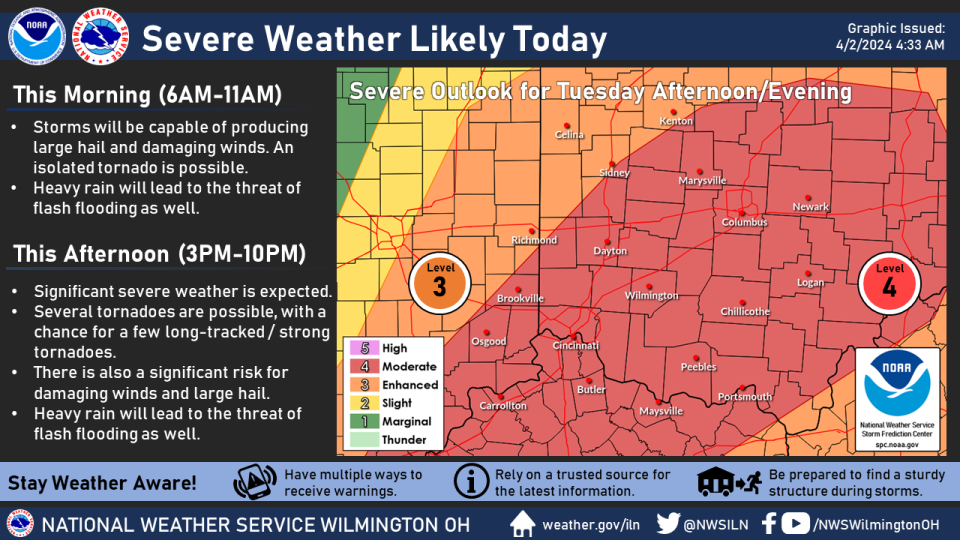
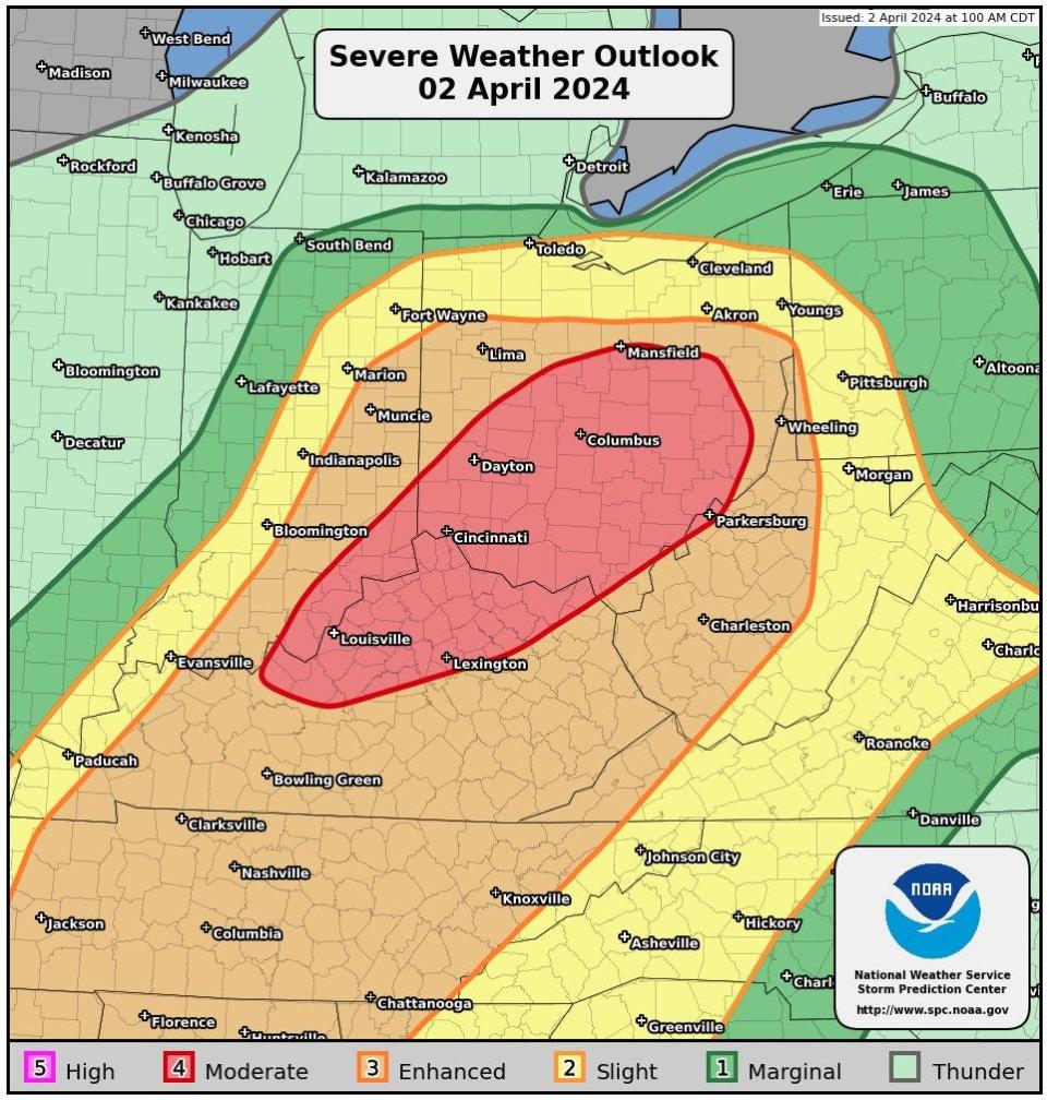
Original report: Storms capable of producing strong tornadoes are possible Tuesday, according to the National Weather Service in Wilmington, with the greatest threat in the afternoon.
All counties in Northern Kentucky, Southwest Ohio and Southeast Indiana are under a moderate, level 4 out of 5, risk of severe weather, according to the weather service.
"Several tornadoes are possible, with a chance for a few long-tracked/strong tornadoes," the agency said.
The weather service also said the nature of the storm will make it hard to create a better timeline or predict where the severe weather will happen.
Severe Weather Discussion for Tuesday, April 2. pic.twitter.com/d30EoCbBir
— NWS Storm Prediction Center (@NWSSPC) April 2, 2024
Timeline for severe weather Tuesday
While the severe weather was initially expected to hit Greater Cincinnati later in the evening, the National Weather Service issued an update just before 10 a.m. moving the timeline up.
The agency warned that storms could occur between noon and 8 p.m. It said the weather system would not produce "linear features" that allow for a more specific timeline.
"Timing and particular threats will be storm-based and could be in multiple locations at the same time," the service said
The threat of severe thunderstorms comes with a flood watch for the region and a flood warning for the Great Miami River at Troy, Taylorsville and Miamitown as well as the Whitewater River Alpine. High winds and large hail are also expected.
What regions are under tornado risk?
The storm front Tuesday stretches from Houston, Texas, all the way north to Canada. Tuesday morning much of Kentucky is under a tornado watch. Rain is predicted along the front, but southern Ohio could be where the weather gets the most extreme Tuesday evening.
Damage in Kentucky
Kentucky sustained substantial damage during storms early Tuesday with more storms expected Tuesday evening, according to Gov. Andy Beshear.
The governor declared a state of emergency in the state just before 2 p.m. Kentucky State Police and Transporation Cabinet and emergency workers have already been deployed to affected areas.
Two EF-1 tornadoes touched down in the state, one in Nelson County and another in Anderson County, and 19 counties have experienced some level of storm damage, officials said.
So far, no injuries have been reported.
"We have more severe weather on the way, and the most important thing we can do right now is make sure everyone has a plan to stay safe,” Beshear said in a statement.
The Emergency Shelter of Northern Kentucky, located at 436 West 13th St. in Covington, has expanded its daytime and overnight occupancy in response to the inclement weather.
Flood warnings issued
A number of flood warnings have been issued Tuesday in anticipation of the heavy rain. A flood watch has been issued for much of the Greater Cincinnati area until 11 p.m. Tuesday.
Warnings have been issued for:
The Great Miami River at Troy, Taylorsville and Miamitown
The West Fork of Whitewater River at Alpine
The Scioto River at Piketon and Circleville
The Big Darby Creek at Darbyville
The Licking River at Newark
The warnings are set to expire late Tuesday.
What is causing the tornado risk
A cold front pushing east is causing the storms. Severe weather is expected to form along the front which extends from the Mid-Atlantic to the Ohio and Middle Mississippi valleys.
In Cincinnati, the temperature is expected to peak around 71 degrees Tuesday afternoon then plummet to the low 40s by Wednesday morning.
The low temperatures will stick around for the rest of the week with snow possible Wednesday night and Thursday morning.
Next Tuesday, April 9, marks the 25th anniversary of the tornado that struck Blue Ash. That tornado reached F4 speeds resulting in the death of four people. The weather service said the 1999 twister demolished 200 homes and another 400 were damaged.
This article originally appeared on Cincinnati Enquirer: Watches and warnings canceled as severe weather leaves Cincinnati area

