Reports: Over 1,000 flights canceled as snow, ice focus on New England
As of 9:15 p.m. EST Wednesday, this story is no longer being updated. Track the remaining snow and ice on radar.
A winter storm is leading to widespread disruptions across the northeastern United States and will continue into Wednesday night.
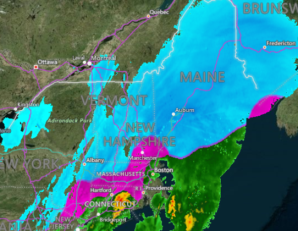
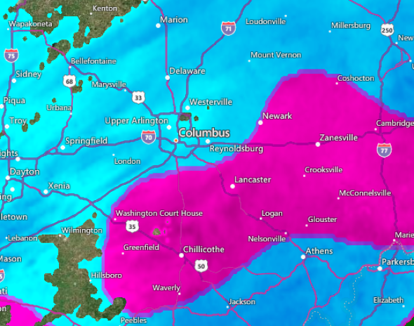
The heaviest snow fell along a zone stretching from central Ohio to the coast of Maine with many locations across interior New England measuring over 6 inches of accumulation.
The storm will spread rain across the southeastern U.S. while snow and ice fall from the lower Midwest to the shores of New England.
It stretches about 2,000 miles from the storms in the South to the snow impacting New England.
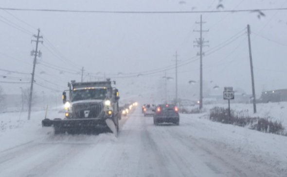
A snow plow truck clears the road on SR 528 in Geauga County, Ohio, during heavy snowfall on Feb. 7, 2018. (Photo/Ohio Department of Transportation District 12)
The heaviest snow will fall across interior New England with upwards of 6 inches accumulating in Albany, New York; Burlington and Montpelier, Vermont; and Portland, Bangor and Caribou, Maine.
Some airlines began canceling flights scheduled for Wednesday on Tuesday afternoon in anticipation for the inclement weather.

8:22 p.m. EST Wednesday:
The northbound lanes on the Maine Turnpike are closed between mile marker 86 and 100. An accident involving a tractor trailer is blocking both lanes.
@WMTWTV Tractor Trailer jacked knife, between exit 86 and and mile 100 north bound on Maine Turnpike pic.twitter.com/DsjvC8cZp5
— Roger (@Rogerjr639) February 7, 2018
#BREAKING: The northbound lanes of the Maine Turnpike are shut down at Exit 86 in Sabattus, due to an accident involving a tractor trailer that is blocking both lanes: https://t.co/hsY5L9Jduh pic.twitter.com/CatFujA1nW
— CBS 13 News (@WGME) February 7, 2018
7:14 p.m. EST Wednesday:
Much of the snow, ice and rain has tapered off across the mid-Atlantic as the worst conditions focus on New England. People driving along Interstate 95 north of New York City should expect to encounter slower-than-normal travel.
5:55 p.m. EST Wednesday:
Many areas from central Ohio to the coast of Maine have recorded 3 to 6 inches of snow, according to the National Weather Service, with snow still falling across much of New England.
The highest snow totals have been reported across Upstate New York with slightly over a foot of snow being measured near Albany, New York.
Moderate to heavy #snow continues in Saratoga Springs, NY with deformation bands. Snowfall totals approaching or slightly exceeding a foot north of Albany where precip type has remained all snow @breakingweather @accuweather #nywx #winterstormwarning pic.twitter.com/DU5RB9CCvf
— Reed Timmer (@ReedTimmerAccu) February 7, 2018
5:20 p.m. EST Wednesday:
Over 1,000 flights have been canceled and another 1,800 delayed at airports across the northeastern US as snow, sleet and ice impact the region, according to FlightStats.
More delays and cancellations are likely into Wednesday night as the worst of the snow and ice focuses on New England.
4:57 p.m. EST Wednesday:
Skyline Drive in Shenandoah National Park is closed due to snow and ice and may remain closed until later this week.

Skyline Drive in Shenandoah National Park on Wednesday afternoon. (Photo/Shenandoah National Park)
3:54 p.m. EST Wednesday:
This winter has officially been the snowiest winter on record in Erie, Pennsylvania.
Snowfall that fell across the city earlier today brought the seasonal total to 152.1 inches, breaking the old record of 149.1 inches set in the winter of 2000-2001.
The 2017-2018 Erie, PA seasonal snowfall has now broken the record with this morning's snowfall. The seasonal total is now at 152.1 inches. The previous record was 149.1 inches from the 2000-2001 season. #pawx #Erie #snow
— NWS Cleveland (@NWSCLE) February 7, 2018
3:19 p.m. EST Wednesday:
At least one fatality has been reported near Moline, Illinois after a multiple vehicle accident on Interstate 280 on Wednesday morning, according to WQAD. Three other people were injured in the accident and taken to the hospital.
2:40 p.m. EST Wednesday:
Over 70 accidents have been reported across Maryland amid wintry weather, according to the Maryland State Police. This number may continue to rise through the evening commute.
#UPDATE Between midnight and 1 pm Wednesday @mdsp responded to 70 crashes and 17 calls of disabled vehicles. Follow https://t.co/jxqlSYD4wc for latest road conditions. #MDtraffic
— MD State Police (@MDSP) February 7, 2018
12:40 p.m. EST Wednesday:
Massachusetts Department of Transportation (MassDOT) reported that 1,461 snow crews are treating and clearing state roads.
#MAtraffic: 1,461 #MAsnow crews at 12pm are treating, clearing state roads. Roads now wet to slush, snow-covered. #DontCrowdThePlow as you travel today. pic.twitter.com/7BQ8dAc6Jc
— Mass. Transportation (@MassDOT) February 7, 2018
12:10 p.m. EST Wednesday:
More than 200 flights have been canceled at Newark Liberty International Airport (EWR), where the FAA is also reporting delays up to 1 hour and 40 minutes on arriving flights.
The FAA is reporting delays of up to 1 hour and 40 minutes on some #EWR arriving flights. Please check with your airline for your flight status. [17]
— Newark Airport (@EWRairport) February 7, 2018
11:55 a.m. EST Wednesday:
A Southwest Airlines plane skidded sideways off a runway at Baltimore/Washington International Thurgood Marshall Airport (BWI) while preparing for takeoff, according to the Federal Aviation Administration.
There were no injuries reported among the 149 passengers aboard Flight 906, which was due to depart for Montego Bay, Jamaica.
Passengers were reportedly transported to another plane following the incident.
— Lilith Christiansen (@LilithVirginia) February 7, 2018
#BWI personnel have worked to move passengers from an outbound aircraft that stopped on taxiway pavement. There were no reported injuries. #MDOTnews
— BWI Marshall Airport (@BWI_Airport) February 7, 2018
.@SouthwestAir 906 slid sideways on a taxiway while preparing for departure at @BWI_Airport today at 10 a.m. It remained on the taxiway & will be towed to the gate. The passengers are being deplaned/bussed to the terminal. Contact the airline for info. FAA will investigate.
— The FAA (@FAANews) February 7, 2018
11:38 a.m. EST Wednesday:
Conditions in Pittsburgh, Pennsylvania, are expected to shift to snowy within the next half hour, according to the National Weather Service. The NWS office in Pittsburgh reported 2.5 inches of snowfall on Wednesday morning with one-quarter of an inch of ice.
#Pittsburgh is the in process of changing over to snow in the next 30 minutes. Sleet is being reported on the east side of town. #pawx
— NWS Pittsburgh (@NWSPittsburgh) February 7, 2018
10:10 a.m. EST Wednesday:
Crashes involving multiple vehicles have shut down all northbound and southbound lanes on the icy Gov. Mario M. Cuomo Bridge in New York.
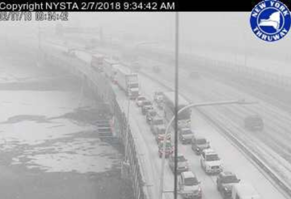
(Photo/New York State Thruway)
According to state police, at least one person was hurt in the crashes, which occurred shortly after 9:30 a.m. EST Wednesday.
Although the accidents took place on the bridge's northbound lanes, state police and emergency responders are reportedly temporarily using the southbound lanes to reach the scene, ABC7 Eyewitness News has reported.
Tappan Zee Bridge CLOSED! Bridge is a solid sheet of ice, Multiple accidents, crews responding SB in the NB lanes for access. EMS reporting 7 total injuries w/ 2 patients unconscious at this time.
Photo Source Unknown pic.twitter.com/jSJfoRSZdH— Kempter's Fire Wire (@KempterFireWire) February 7, 2018
ALERT - SEEK ALTERNATE ROUTES: ALL LANES ARE BLOCKED northbound and southbound on the Gov. Mario M. Cuomo Bridge due to an accident. Motorists should expect long delays and seek alternate routes. https://t.co/ijfzP4gQba
— NYSThruwayAuthority (@NYSThruway) February 7, 2018
Wayyyyyyy backed up following Cuomo bridge lane closures from multiple car wrecks. @NBCNewYork pic.twitter.com/wR0JIm34km
— Ken Buffa (@KenBuffa) February 7, 2018
9:45 a.m. EST Wednesday:
AccuWeather Meteorologists Bernie Rayno and Laura Velasquez are live from AccuWeather Studios as they continue to track the winter storm throughout the morning.
9:19 a.m. EST Wednesday:
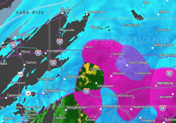
Slick travel conditions continue to plague many drivers in the Northeast. The Pennsylvania Department of Transportation has reported several crashes, some involving multiple vehicles, which have resulted in travel delays in various parts of the state.
Two multi-vehicle crashes were reported on Interstates 81 and 83 near Harrisburg, according to 511PA.
A crash on Interstate 81 near Harrisburg, Pennsylvania, blocks a lane of traffic. (Photo/511PA)
Reports of 3-6" of snow north of US 422 in PA. Snowfall rates of 1" per hour will continue through the midday hours.
— NWS Pittsburgh (@NWSPittsburgh) February 7, 2018
The winter storm is also affecting air travel at some airports, including New York's La Guardia Airport. Snow and ice are causing delays of about 1 hour and 8 minutes for flights heading there, according to the Federal Aviation Administration.
More than 100 flights have been canceled at #LGA due to forecast weather. Please check with your airline for your flight status. [10]
— LaGuardia Airport (@LGAairport) February 7, 2018
7:58 a.m. EST Wednesday:
Icy, slippery roads are contributing to traffic accidents in parts of the eastern U.S., including at least one crash on Interstate 83 in Maryland, according to the Maryland Department of Transportation.
.@MDSHA is re-applying salt to I-83 South starting at Old York Road. All lanes remain closed due to an overturned vehicle at Old York Road. The queue extends to the PA line. Three salt trucks will lead the southbound traffic in an effort to treat and provide safe transit. jts
— MD State Highway Adm (@MDSHA) February 7, 2018
Maryland State Police are advising travelers to avoid staying out on the roads, particularly north and west of Baltimore until late Wednesday morning.
The Baltimore City Department of Transportation tweeted that thus far, workers have applied more than 300 tons of salt to slick roads.
Nasty out across western portions of #Maryland this morning. Lots of ice and even snow built up on I-68 and I-70 this morning. @frostburgstate @CumberlandMD @alleganycounty @garrettchamber @garrettcountymd #mdwx pic.twitter.com/rB7HZrFEs7
— Erik Taylor (@WeatherErik) February 7, 2018
6:46 a.m. EST Wednesday:
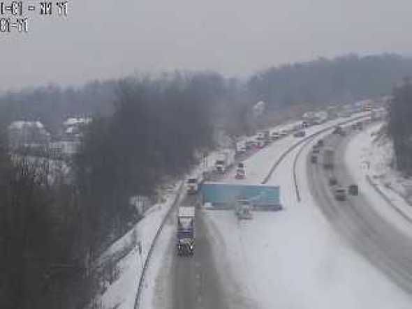
Dangerous travel is being reported in Licking County, Ohio, located in the central part of the state, just east of Columbus.
Licking County is under a level 2 Snow Emergency
Roadways are hazardous with blowing and drifting snow. Only those who believe it is necessary to drive should be out on the roadways. Contact your employer to see if you should report to work
Sheriff Randy Thorp
Licking County Ohio— Sheriff Randy Thorp (@rthorp45) February 7, 2018
6:17 a.m. EST Wednesday:
Workers for the Ohio Department of Transportation are moving quickly to clear accumulating snow falling over much of the state.
In a race with Mother Nature, she's winning as local & state plows work to clear fast falling snow. @ODOT_Columbus says best progress will be made once snow stops. @AndrewWSYX6 says snow likely ends mid-morning. #OhioWX pic.twitter.com/SLjQ4bMBr9
— Mike McCarthy (@mikewsyx6) February 7, 2018
In addition to the treacherous travel conditions caused by thick and heavy snow accumulating in central Ohio, most school districts in the area have announced closures on Wednesday, according to The Columbus Dispatch.
Still a moderate snowfall coming down in #Beavercreek #Ohio! And we're up to 3'' of snow here. Will we break 4''? I doubt it. This will be the 4th storm in a row with snow accum. at my place between 3.0 and 3.9''. Kinda sad. Need at least 1 storm 6''+! #daywx #ohwx pic.twitter.com/9xCetYJ8MQ
— OhioWxGirl (@OhioWxGirl) February 7, 2018
5:43 a.m. EST Wednesday:
The Pennsylvania Department of Transportation has reduced speeds to 45 mph on interstates in Allegheny, Beaver and Lawrence counties. Speeds have also been reduced on many other major roadways across the state, and motorists are urged not to travel unless necessary.
PennDOT trucks are currently applying an anti-skid and salt mix to roads due to the expected icy conditions.
Public schools in Pittsburgh are closed in anticipation of the storm.
Today, Wednesday, February 7, 2018, Pittsburgh Public Schools are CLOSED. #PPSStayInformed
— Pgh Public Schools (@PPSnews) February 7, 2018
A post shared by Scott Harbaugh (@wpxiscott) on Feb 7, 2018 at 2:08am PST
4:30 a.m. EST Wednesday:
Overnight ice accretion in areas from Arkansas to Indiana has shifted into the southern Ohio Valley, causing early-morning travel issues across the region.
Local law enforcement, meteorologists, trained spotters and the general public have reported widespread instances of slick roads and sidewalks, promising an upcoming icy and hazardous morning commute for many.
Ice is accumulating on one of our rain guages here @NWSLittleRock. #arwx pic.twitter.com/9prgf8xgGa
— NWS Little Rock (@NWSLittleRock) February 7, 2018
In Oil Trough, Arkansas, ice accretion reportedly grew to a thickness of one-quarter of an inch on elevated surfaces.
Very heavy snow is falling at the front end of this storm, as evidenced by the 2 inches of snow that accumulated in Columbus, Ohio, in just two hours. Roads will quickly become slick, and visibility will plummet to 1 mile or less at the onset of snow, making travel especially hazardous this morning.
We have more than 1,000 crews out plowing and treating roads across the state. Here are two of them working in the Columbus area. Please give them plenty of room to work and plan for a slow commute this morning. #ODOTwinter pic.twitter.com/VdPFKvlHKU
— Ohio Dept of Transportation (@ODOT_Statewide) February 7, 2018

