Reports: Severe outbreak unfolds across Wisconsin with damaging wind, tornado threat
Severe weather is bearing down on the Midwest and will pose a significant risk to lives and property across the region into Wednesday night.
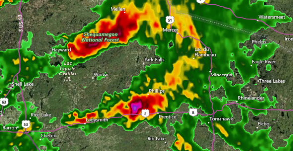
The highest threat for severe thunderstorms will focus on a zone from central Wisconsin through northern Michigan, including the risk of damaging winds, hail and tornadoes.
"The most likely time for violent thunderstorms is expected to range from 3 to 9 p.m. CDT," AccuWeather Expert Meteorologist Alex Sosnowski said.
The timing of the storms could bring delays to the Wednesday evening commute across the region, including around Madison, Green Bay and Milwaukee, Wisconsin.
Download the free AccuWeather app to keep up with the latest warnings and minute-by-minute forecast for your location.

7:40 p.m. CDT Wednesday:
Washington County, Minnesota 911 call center reports wind damage and downed trees near Woodbury, Minnesota, from a possible tornado.
7:35 p.m. CDT Wednesday:
A powerful supercell with broad rotation, large hail and damaging winds is heading north toward Hurricane, Utah in the direction of Zion, National Park.
Supercell with broad rotation, large hail, damaging winds heading north toward HURRICANE, Utah in the direction of Zion NP! This is a very dangerous storm @breakingweather @accuweather @Rankinstudio #utwx pic.twitter.com/N76IuHHXZ4
— Reed Timmer (@ReedTimmerAccu) October 4, 2018
7:10 p.m. CDT Wednesday:
AccuWeather Extreme Meteorologist Reed Timmer reports a likely tornado near Mattoon, Wisconsin, as of 7:09 p.m. CDT, heading toward Zoar and Neopit, Wisconsin.
Likely #tornado near Mattoon, WI as of 7:09 pm heading toward Zoar, Neopit WI next! This is a dangerous storm! Take shelter in the red box @breakingweather @accuweather #wiwx pic.twitter.com/E9vsWeJD6a
— Reed Timmer (@ReedTimmerAccu) October 4, 2018
7:07 p.m. CDT Wednesday:
There is a Tornado Warning issued for Neopit, Mattoon and Zoar, Wisconsin, until 7:30 p.m. CDT.
Tornado Warning including Neopit WI, Mattoon WI, Zoar WI until 7:30 PM CDT pic.twitter.com/Ne1T0go64O
— NWS Tornado (@NWStornado) October 4, 2018
6:07 p.m. CDT Wednesday:
The National Weather Service (NWS) has issued a Tornado Warning including River Falls, Baldwin and Spring Valley, Wisconsin, until 6:45 p.m. CDT.
Tornado Warning including River Falls WI, Baldwin WI, Spring Valley WI until 6:45 PM CDT pic.twitter.com/dovSV76bn7
— NWS Tornado (@NWStornado) October 3, 2018
3:30 p.m. CDT Wednesday:
A tornado watch has been issued for eastern Minnesota, northern Wisconsin and part of Michigan's Upper Peninsula until 11 p.m. CDT Wednesday.
A tornado watch means that conditions are conducive for tornadoes, while a tornado warning means that a tornado is imminent, and that you should seek shelter immediately.
A tornado watch has been issued for parts of Michigan, Minnesota and Wisconsin until 11 PM CDT pic.twitter.com/DyTIF4VAmn
— NWS Tornado (@NWStornado) October 3, 2018
3:20 p.m. CDT Wednesday:
Severe thunderstorms are starting to blossom over the Midwest with one storm already producing frequent lightning and quarter-sized hail east of Hawkins, Wisconsin.
Thunderstorms are expected to become more widespread across the region over the next few hours.