Reports: Homes damaged, firefighter injured as severe storms sweep across the Tennessee Valley
As of 2:00 a.m. EDT Saturday, the reports below are no longer being updated. Click here for a photos recap of Friday's severe weather.
A new round of severe weather is threatening lives from Ohio through Tennessee and will continue into Saturday morning.
The severe storms are being caused by the same weather system that spawned destructive tornadoes in Iowa and severe storms in Branson, Missouri. It occurred at the same time that a boat overturned and killed 17 people on Thursday.
All modes of severe weather will be possible as storms from Kentucky to Mississippi bring the threat of winds over 60 mph, hail larger than golf balls and isolated tornadoes.
"The storms may produce hail large enough to damage crops, break windows and dent the metal on vehicles," AccuWeather Senior Meteorologist Alex Sosnowski said.
"A single tornado that strikes a populated area can threaten a great deal of lives and property," Sosnowski said.

11:50 p.m. EDT Friday:
The threat for severe weather is continuing well after dark, with one storm capable of producing a tornado in northwest Mississippi.
Tornado Warning continues for Cleveland MS, Shelby MS, Mound Bayou MS until 11:30 PM CDT pic.twitter.com/AR7wM3BMNe
— NWS Jackson MS (@NWSJacksonMS) July 21, 2018
People heading to bed should keep cell phones on and fully charged with the volume turned up in order to be alerted when severe weather is imminent. If you have a weather radar, be sure to keep it close by.
10:25 p.m. EDT Friday:
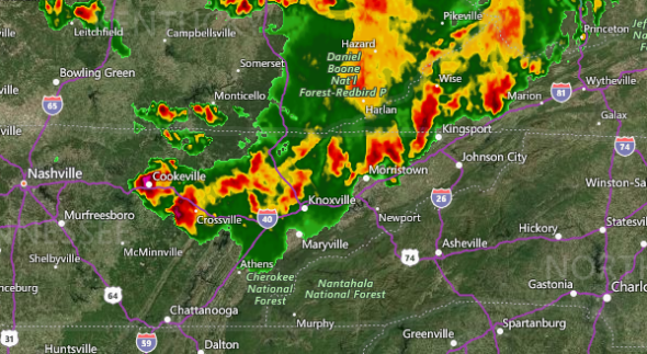
A line of severe thunderstorms is advancing across eastern Tennessee and has a history of producing strong winds and hail as large as pin pong balls. This line of storms will continue to advance eastward through Friday night.
9:07 p.m. EDT Friday:
A severe thunderstorm capable of producing a tornado is currently over Patesville, Kentucky, located southwest of Louisville, and is headed toward McQuady and Glen Dean.
Tornado Warning including Hardinsburg KY, McQuady KY, Glen Dean KY until 8:30 PM CDT pic.twitter.com/6tVXanxBgL
— NWS Louisville (@NWSLouisville) July 21, 2018
8:40 p.m. EDT Friday:
Over 105,000 electric customers are without power across Kentucky as severe thunderstorms move across the state. These numbers may continue to rise as storms persist into the overnight hours.
@ShawnReynolds_ Crazy clouds and storm rolling into the East End of Louisville!! pic.twitter.com/JQmIh5zNga
— Jeff Pile (@Jeff_Pile) July 21, 2018
7:20 p.m. EDT Friday:
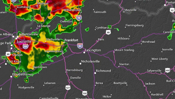
Another round of thunderstorms is approaching Louisville, Kentucky, from the northwest. These storms may bring gusty winds, small hail and heavy downpours.
A new tornado watch has been issued from far southwestern Indiana to northern Mississippi. This means that conditions are conducive for thunderstorms to produce tornadoes in this area into Friday night. People in this area should pay close attention to the weather and seek shelter when a storm approaches.
6:23pm CDT #SPC_Watch WW 294 TORNADO AL AR IL IN KY MO MS TN 202320Z - 210700Z, https://t.co/jH8AfbdLZJ pic.twitter.com/AbGqfxxgjD
— NWS SPC (@NWSSPC) July 20, 2018
5:50 p.m. EDT Friday:
One firefighter was injured and over a dozen homes were damaged near New Middletown, Indiana, earlier today when a tornado-warned thunderstorm moved through the area. New Middletown is located approximately 15 miles southwest of Louisville, Kentucky.
Ind. State Police reports tornado damage to about 20 homes in New Middletown area of Harrison Co., Ind. One minor injury to a firefighter. Updates @WDRBNews at 6 p.m. pic.twitter.com/uwu0NbLIaN
— Chris Turner (@ChrisTurnerWDRB) July 20, 2018
4:20 p.m. EDT Friday:
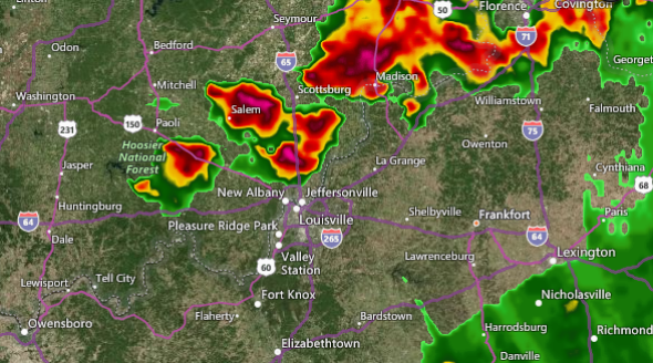
A wind gust of 70 mph was measured at Lexington Blue Grass Airport as severe thunderstorms moved through the city. The animation below shows the weather radar as storms moved into the Lexington area with strong wind gusts.
3:30 p.m. EDT Friday:
Hail as large as golf balls have been reported just south of Louisville after a severe thunderstorm moved through the area. Strong wind gusts have also blown over some trees south of the city.
Large hail has also fallen in Madison, Indiana, as a line of severe storms moved through the area.

Large hail in Madison, Indiana, on Friday afternoon. (Photo/Teresa Kelly)
2:16 p.m. EDT Friday:
A confirmed tornado was located near New Middletown, Indiana, and was moving east. This is a particularly dangerous situation. People in the path of the storm should take cover until the storm has passed.
Tornado Warning continues for Elizabeth IN, New Middletown IN until 2:45 PM EDT pic.twitter.com/dCHhX7S23J
— NWS Louisville (@NWSLouisville) July 20, 2018

