Relentless downpours to create travel delays, flash flood concerns in the Mississippi Valley
The same storm system that produced deadly flooding in Texas late last week will channel rounds of heavy downpours into the lower Mississippi Valley during much of this week.
The White Rock Creek at Dallas crested at an all-time record of 91.47 feet on Saturday morning, according to the National Weather Service, and the floodwaters also forced evacuations and claimed one life.
Through midweek, the axis of heaviest rainfall will shift farther to the east, stretching from Louisiana and western Mississippi to much of Arkansas, Tennessee and Kentucky, southeastern Missouri and southern Illinois and Indiana.
A deep and unusually persistent flow of tropical moisture from the Gulf of Mexico is to blame for the extended stretch of wet weather.
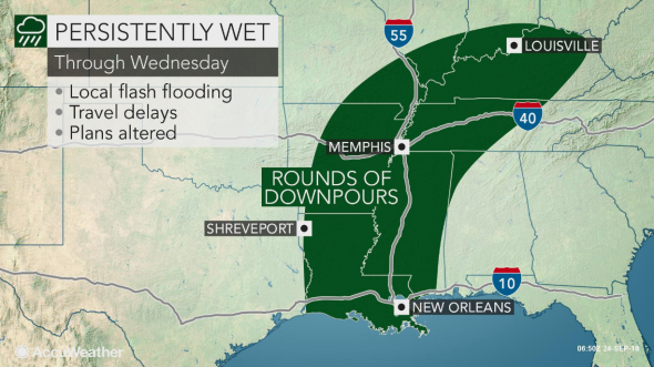
Cities that lie within the threat zone through Wednesday include New Orleans and Baton Rouge, Louisiana; Little Rock; Tupelo and Jackson, Mississippi; Memphis and Nashville, Tennessee; and Louisville and Lexington, Kentucky.
Motorists with travel plans along portions of interstates 10, 20, 40 and 55 should be prepared for delays and allot extra time to get to their destination.
The risk for hydroplaning increases when traveling at highway speeds and visibility can drop to a few hundred feet in a short distance when a blinding downpour occurs.
To reduce the risk of traffic accidents, reduce speed and, if necessary, pull off the side of the road until the rain lessens in intensity.
In comparison to what happened last weekend, the coverage of flooding downpours will lessen on Tuesday and Wednesday.
However, some stronger storms could bring locally gusty winds to the mid-Mississippi Valley on Tuesday.
A punch of drier air from the north should put an end to the wet weather in northern portions of the threat zone by Wednesday and Thursday.
However, it will take until Friday or even Saturday for generally dry weather to reach the lower Mississippi Valley.
Download the free AccuWeather app to find out when drier weather will return to your location.
An additional one half to 2 inches of rain is expected to fall in the threat area through midweek.
"Over the next day or two, as much as 3 inches of additional rain may fall in cities such as Nashville, Tennessee, or Jackson, Mississippi, leading to localized flash flooding," AccuWeather Meteorologist Isaac Longley said.
Because some flood gauges in the lower Mississippi Valley are already near minor flood stage, this amount of rain will be too much for some area streams, creeks and rivers to handle.
Residents living in flood prone or low-lying areas should have a plan of action ready in case waters rise.
Motorists should never attempt to drive through roadways covered in water. It is impossible to judge the depth of the water using only the naked eye, and only 1-2 feet of moving water can sweep a vehicle away.
Barring a direct hit from a tropical system, there does not appear to be any more prolonged periods of persistently wet weather on the horizon into at least the first week of October once drier weather returns by the weekend.

Do you think it'll rain? Click the image above to play Forecaster Challenge and make your prediction.
