At least 4 dead in Houston as destructive storms lash Texas and Louisiana with strong winds and flood threats
- Oops!Something went wrong.Please try again later.
Editor’s Note: Coverage of this storm system has moved here.
At least four people are dead in Houston after hurricane-force winds and torrential rains tore a damaging path through the city Thursday – part of a lashing storm system that is bringing life-threatening flooding and power outages to parts of the South.
Severe storms carved through parts of Texas Thursday before pushing into western Louisiana through Friday’s early hours, prompting an overnight flash flood warning for New Orleans. As the sun rises Friday, several cities in the storm’s path will begin to take stock of damage left in the storms’ wake.
One person was killed in Houston when a crane was toppled by strong winds and two other deaths were caused by fallen trees, according to Houston Fire Chief Samuel Peña, citing preliminary information.
Violent storms in Houston blew out skyscraper windows, partially collapsed a nightclub and ripped a strip of roofing off the downtown Hyatt Regency, showering the hotel lobby with rain and debris, according to witness video.
All non-essential workers are urged to stay home tomorrow and city schools are closed as widespread power outages have darkened the city and disabled traffic lights, Mayor John Whitmire said. Streets are littered with debris, downed trees and power lines, and the downtown area is dusted with glass from broken windows, he added.
Major flooding has prompted water rescues in at least one Texas city. As many as 20 drivers had to be helped from rising water in Bryan, about 100 miles northwest of Houston, police said.
Power outages left more than 900,000 homes and businesses in the dark across Texas as of Thursday night. More than 200,000 are also without power in Louisiana as storms batter the state.
Possible tornadoes posed a risk in Texas and Louisiana, and carried the threat of destructive winds and golf ball-sized hail. A reported tornado in Convent, Louisiana, downed trees and power poles late Thursday, the Storm Prediction Center said.
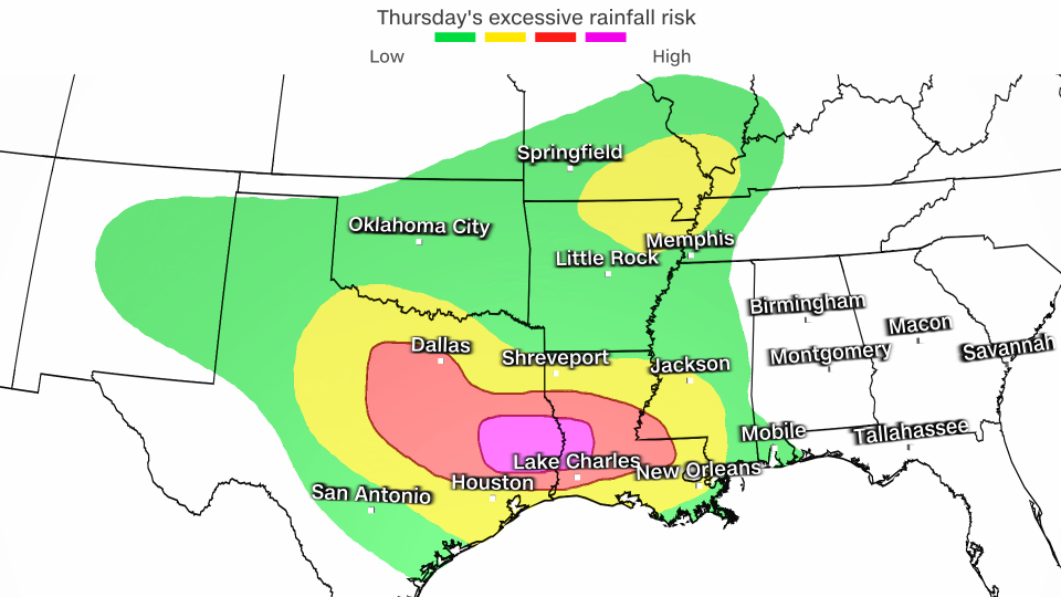
Parts of Texas and western Louisiana are under a rare Level 4 of 4 high risk of excessive rainfall Thursday, the Weather Prediction Center said. More than 600, 000 people live in the high-risk zone.

High risk days like this only happen on 4% of days each year, but account for more than 80% of all flood damage and more than a third of all flood deaths in the United States, according to the WPC. Just three other days have reached this concerning mark this year, including the most recent one nearly three weeks ago.
It’s a sign the atmosphere is primed to unload extreme amounts of rain, a phenomenon that is becoming more frequent in a warming world driven by human-caused climate change.
Widespread rainfall totals of 2 to 6 inches are expected from Texas to Georgia through Saturday morning. A few spots caught under multiple torrential storms may pick up 8 inches or more of rain. It’s not out of the question that one or two spots could record close to a foot of rain in about 48 hours.
Texas and Louisiana have been in the bull’s-eye of seemingly unrelenting rounds of torrential, flooding downpours since the start of April. Rainfall in the waterlogged area over the last two weeks is over 600% of what’s typical, according to the WPC.
Double-digit rainfall totals between 20 and 30 inches over the region in recent weeks have soaked the ground and left rivers swollen, priming the flood threat to extreme levels.
Drenched soils are not expected to soak up any of Thursday’s rainfall, the WPC warned Thursday morning. Widespread flash flooding could begin minutes after heavy rain starts to fall.
Flooding ramps up Thursday and threat persists Friday
Storms, some severe, rumbled to life Thursday afternoon in parts of Texas and prompted flash flood warnings for multiple cities, including Waco. Powerful, heavy storms will push south and east and reach Louisiana and Mississippi late in the day.
More than 800,000 outages have been reported in Harris County, where Houston is located, according to PowerOutage.us. Harris County is the third-most populous in the United States.
A tornado warning had been issued earlier Thursday evening in Harris County, including downtown Houston, according to the National Weather Service. The weather service also issued a severe thunderstorm warning for Houston with the highest-level “destructive” tag.
At around 6:30 p.m., the weather service in Houston noted a “destructive storm” with wind gusts of up to 80 mph was over the metro area, and urged residents to take cover immediately in a post on X.
Winds in the city were reported as high as 71 mph, according to the weather service. On the east side of the city, there were reports of winds up to 78 mph – equivalent to the strength of a Category 1 hurricane.
Multiple steel power transmission towers in Houston have been mangled by the storms, CNN affiliate KPRC reported. Along part of US Route 290, traffic was stopped as firefighters cleared downed lines draped over the roadway.
Houston Mayor John Whitmire advised residents to stay off the roads.
“The mayor and first responders are asking Houstonians to stay off the roads and avoid all unnecessary travel. Many roads are impassible due to downed power lines, debris, and fallen trees,” the mayor’s office said in a statement Thursday evening. “There are significant power outages and reports of damage across the city. We are working with Centerpoint, METRO and other regional partners to keep everyone safe.”
Rainfall rates up to 3 inches per hour are possible in the heaviest storms, which could lead to life-threatening flash flooding, according to the WPC. Damaging winds, hail and a couple of tornadoes are also possible.
The greatest flooding danger will come as storms train later Thursday. Training storms track through and deluge the same areas over and over, like a train pulling its cars over the same stretch of track.
Serious flash flooding is likely in any areas caught under multiple storms unloading 2 to 3 inches of rain per hour. Roadways may quickly become rivers and small streams could easily overflow their banks.
More than 35 million people in the South are under a Level 2 of 4 or Level 3 of 4 risk of excessive rainfall Thursday. Many areas may only endure one torrential storm, but even brief downpours will be enough to cause flooding problems given how wet the South has been recently.
Drenching storms from Thursday night will last into Friday for parts of the Gulf Coast. An initial round of flash flooding is likely in the first half of Friday before rain starts to taper off in the afternoon.
Another bout of heavy rain will develop Friday night and continue into the earliest hours of Saturday morning, working over the same areas hit earlier in the day. These storms could produce rainfall rates of 2 to 3 inches per hour, and quickly restart or worsen any ongoing flooding.
Extremely wet start to the year
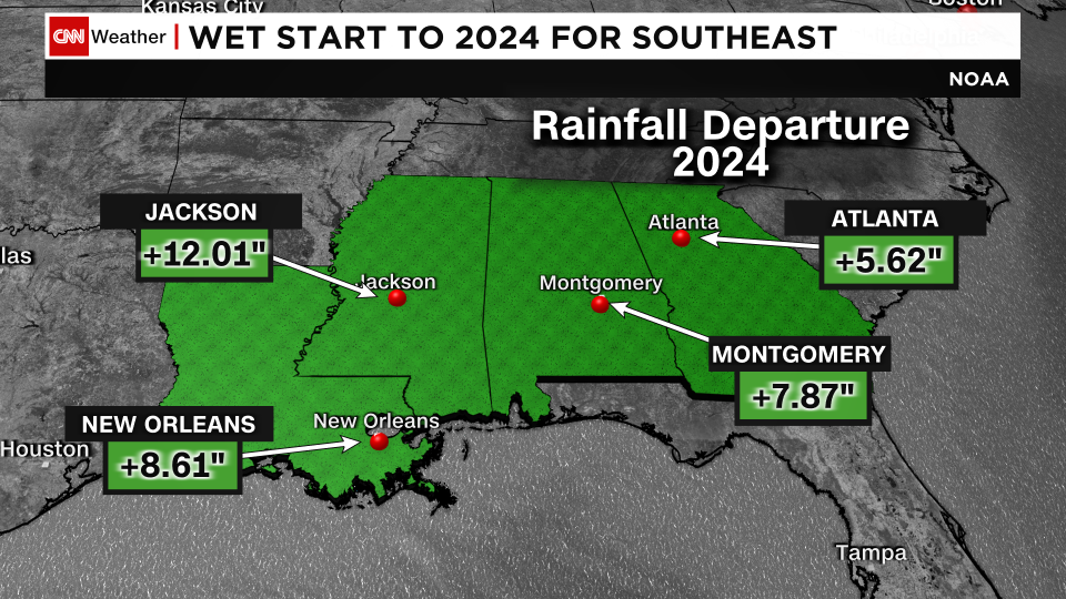
The rain will only add to already extreme rainfall totals in what’s been one of the wettest years to date on record across the Gulf Coast.
Some Southeast cities have recorded more than half a foot of rain above what’s typical for the first several months of the year.
Several dozen cities from Texas to western Georgia are pacing at a top 5 wettest year to date and at least two cities in eastern Texas are experiencing their wettest year, according to the Southeast Regional Climate Center. Dallas is experiencing its third-wettest year to date while Shreveport, Louisiana, is amid its second wettest.
Excessive rainfall has largely eliminated dryness and drought conditions along the Gulf Coast, but it hasn’t come without a cost.
Earlier this month, nearly 2 feet of rain fell in just five days and sent parts of eastern Texas underwater. Hundreds of people and animals were rescued from flooding as some area rivers rose to levels not reached since Hurricane Harvey in 2017.
CNN’s Ashley R. Williams, Mary Gilbert, Brandon Miller and Taylor Ward contributed to this report.
For more CNN news and newsletters create an account at CNN.com

