Rare blizzard conditions batter California mountains with heavy snow and powerful winds, making travel dangerous
A dangerous winter storm is slamming Northern California with rare blizzard conditions and fierce winds as it threatens to unload up to 10 feet of snow in the mountains and snarl travel.
In the Sierra Nevada, the storm is delivering heavy snow, reduced visibilities, toppled power lines and hurricane-force winds over 75 miles per hour, which are expected to roar through the weekend.
Over three feet of snow has been measured so far, and an additional one to two feet is likely in higher elevations and six to 10 inches elsewhere, according to the National Weather Service.
About a half million people are under blizzard warnings in the Mountain West, with another 6 million under winter weather alerts across the region.
Extreme snowfall at high elevations
The weather service on Friday warned of “high to extreme” avalanche danger through Sunday afternoon in the Central Sierra and Greater Lake Tahoe area.
The most extreme conditions are unfolding at the highest elevations, where snowfall rates could top three to five inches an hour through Saturday, threatening road closures and increasing the risk of avalanches.

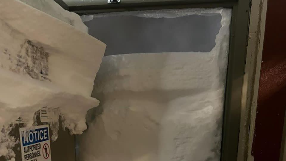
The ski resort Sierra-at-Tahoe in Twin Bridges, California, is closed after at least three to four feet fell at the top of the resort. An image shared with CNN shows how wind drift caused snow to pile up against the door of the resort’s maintenance shop. Another shows a car in the resort’s guest parking buried in snow that fell overnight.
“We, along with most other resorts, will be closed today so our lift operations team can focus on clearing the roads,” Shelby Dunlap, communications manager at the resort, told CNN.
Models are showing an additional 3 feet of snow at high elevations by Saturday morning, and blizzard conditions continuing through the day. Those blizzard conditions will move into eastern Nevada Saturday morning, and blizzard warnings are in effect from Saturday morning into Saturday evening.
Whiteout conditions on roads
Extreme snowfall and roaring winds combining to produce long-lasting blizzard conditions for much of the Sierra and parts of the northern ranges will mean blowing snow and whiteout conditions, making travel “impossible,” the National Weather Service warned.
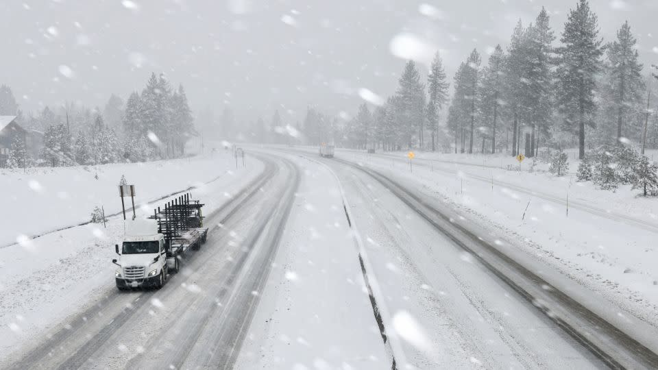
Visibility has already plummeted to near-zero in some areas, meaning it’s impossible to see farther than a few feet, or at all.
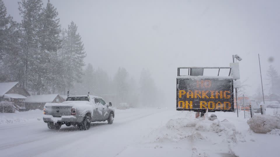
A stretch of Interstate 80 was shut down at the Nevada state line Friday as California Highway Patrol reported spin-outs and low visibility.
According to an update from California Highway Patrol Truckee, I-80 remains closed Saturday between the Nevada state line and Colfax, California.
“Last night, we had a mass amount of vehicles stuck over Donner Summit and it took several hours for emergency personnel and tow trucks to reach motorists,” the update said. “At one point, emergency personnel and tow trucks had a difficult time getting to motorists due to blizzard conditions.”
Caltrans District 3, which maintains the state highway system in 11 Northern California counties, is currently evaluating the roads and CHP plans to work on recovering vehicles left on the freeway after motorists were transported to a safe location last night.
“There is no estimated time of reopening the freeway, so we suggest you stay home. Stay warm and don’t put yourself and your family in a dangerous situation,” CHP added.
Amtrak canceled the Friday departure of its California Zephyr service from Chicago to San Francisco, since it passes through Truckee, California, in the high country, which is under a blizzard warning until Sunday morning.
Power outages for tens of thousands
Power outages are growing, with more than 39,000 homes and businesses without power in California Saturday morning, according to the tracking website PowerOutage.us. The number is expected to jump sharply as winds strengthen. Some 16,000 customers are without power in Idaho and about 15,000 in Nevada, according to the site. Another 12 Wind alerts are posted across nine western states, covering nearly 20 million people.
Threats to lower elevations
The National Weather Service in Reno said in addition to huge snow totals in the mountains, significant snow could fall at lower elevations, “even as much as 6-14 inches in the Reno-Carson-Minden corridor,” the office said in its forecast discussion.
Even the Las Vegas area has a rare blizzard warning in effect for Lincoln County, Nevada, where they’re expecting 2 to 5 inches of snow with winds up to 70 mph, according to the Las Vegas weather service office.
Yosemite National Park is closed at least through Sunday at noon, according to the National Park Service.
A Blizzard Warning is in effect for the area of the park until Sunday morning, according to the National Weather Service in Hanford, California. Higher elevations of the park could see 5-10 feet of snow in the coming days.
Unlike other storms this winter, snow is falling well below pass levels for all impacted ranges. Close to a foot of snow is expected through the weekend for areas as low as 5,000 feet. Several inches are also possible for even lower elevations, including Reno, Nevada. Wind gusts of up to 60 mph will continue to blow through the lower elevations alongside snow.
The intense conditions at lower elevations increase the risk of danger on the road.
Travel will remain “extremely dangerous to impossible” across the Sierra through the weekend, the weather service warned.

Snow could boost California water supply
One upside of the storm will be its effect on the state’s water supply. Snowpack in some areas is already at 80% of the March average and could jump sharply.
Recent storms have helped make a difference. Parts of the Sierra are closing in on erasing the snowpack deficit.
The snowpack was at 80% of its March average, a survey conducted by California’s Department of Water Resources found Thursday – which represents what was on the ground before the current storm.
The storm currently hitting the Sierra will be factored into the April snow survey. The April survey is viewed as the most consequential since officials use the measurement to forecast the state’s water resources for the rest of the year. The survey showed snowpack was 70% of the April average.
Millions of people in the West depend on a melting snowpack in the warmer months for hydropower, irrigation and drinking water, according to the US Environmental Protection Agency.
CNN’s Mary Gilbert, Elliana Hebert, Sara Tonks Stephanie Elam contributed to this report.
For more CNN news and newsletters create an account at CNN.com

