Misery in Houston with power out and heat rising; Kansas faces wind risk
Hundreds of thousands of Texans sweltered in unrelenting heat and humidity Sunday as a fleet of utility workers tried to restore electricity three days after a derecho and a few tornadoes slammed the Houston area, leaving seven dead.
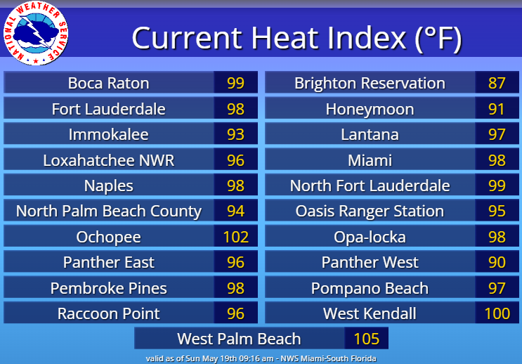
The heat index – what the temperature feels like – is expected to increase in the Houston region each day through the first half of the week, reaching into the triple digits on Tuesday and Wednesday. The largest electricity provider in the region, CenterPoint Energy, estimated that 80% of its 2.6 million customers would have power restored by Sunday night.
Meanwhile, more than 9 million people face a slight to moderate risk for more severe weather on Sunday afternoon and evening as the National Weather Service reported the possibility of a similar high wind derecho event in central Kansas. A slight risk of severe weather extends northward from Oklahoma into South Dakota, across western Nebraska and into the northwest corner of Missouri.
The weather service had warned of 80 to 100 mph destructive winds, large hail, and a few tornadoes, and all of that materialized through the evening. A tornado was confirmed Sunday afternoon southwest of Russell, Kansas, about 148 miles northwest of Wichita.
The weather service also reported 2-inch hail and around 70 mph winds in parts of central Kansas.
"The storms in Newton and Sedgwick counties have produced structural damage, downed power lines, and turned over semis," the weather service in Wichita said on X. "80-90 mph winds have been observed! Seek shelter now in southern Marion, southern Chase, and northern Butler Counties!"
A slight risk of severe weather also is forecast for the Southeast Florida coast from north of Cape Canaveral south to Miami. A heat advisory is also in effect for the South Florida region on Sunday, and a heat index of 106 to 110 is possible in Miami and the Florida Keys.
The weather service warned Sunday that "intense summer-like heat" will continue across the Central U.S. from southern Texas into the southern High Plains on Monday and Tuesday, with possibly record-breaking temperatures soaring into the triple digits.
Severe weather updates on Sunday
Storms already were being reported in Nebraska before noon Central Time on Sunday. In Red Willow County, rain of 3.05 inches and 2.89 inches had fallen by 10:15 a.m., the weather service said. Normal rainfall for May in nearby North Platte is 3.2 inches.
In Kansas, the weather service said the most severe storms were expected to affect central Kansas and portions of northeast Kansas, and there was the possibility of winds of more than 80 mph moving into the area after 7 p.m. local time, and moving into Missouri shortly after midnight.
2-3 inch hail was reported in Ellis, Kansas, around 2:25 p.m. local time., where a severe thunderstorm warning was issued, the weather service said.
In Oklahoma, a tornado emergency was declared near Custer City, about 90 miles west of Oklahoma City, at 7:40 p.m. and the weather service warned people to "(t)ake cover now!" The alert was later canceled shortly before 8 p.m. but a tornado warning was still in effect.
By midnight, Eastern Time, the weather service had preliminary reports of as many as eight tornadoes, with three each in Kansas and Oklahoma and two in Colorado.
Winds of 60 to 80 mph were reported across a broad swath of Oklahoma and Kansas, with some of the highest winds reported in Butler and Sedgwick counties in Kansas, and Custer, Oklahoma. Among the higher gusts reported was an 86 mph gust at the Hutchinson Airport in Reno, Kansas.
According to PowerOutage, U.S., at midnight Eastern Time, 44,578 power outages were reported in Kansas, and 7,595 in Oklahoma. The total in Texas had dropped to an estimated 237,593.
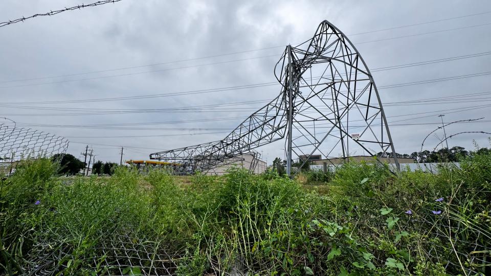
Houston storm toppled high voltage towers
The derecho storm in Texas on Thursday evening toppled high voltage towers and trees and took out electrical lines throughout the region, causing an estimated $5 billion or more in damage.
The city of Houston posted on X Sunday morning that it will be working to determine "if Houstonians can safely return to work downtown or should work from home Monday." Besides the restoration of electricity, the city said its priorities are on providing ice, water and cooling centers to affected residents.
On Saturday night, CenterPoint Energy said more than 2,000 employees and 5,000 contractors were working in the region. They expect to have storm-related restorations "substantially completed" by Wednesday evening.

Prioritizing key public safety facilities such as hospitals, police and fire departments and water treatment plants, the company stated it restored about 60% of the outages – more than 550,000 customers − in the first 48 hours after the storm.
"We made progress overnight but there is still more work to be done," the company posted on X on Sunday morning. "Crews − including the mutual assistance support − are rolling out across the city to continue the work of getting power back on to the remaining impacted customers."
On Saturday, Lynnae Wilson, the company's senior vice president for electric business, said: “We understand the higher temperatures we are experiencing across Houston and surrounding communities make getting the lights and air conditioning back on even more important."
Electricity also remains out for about 3,800 customers in western Louisiana, which also caught a piece of Thursday's storms.
In addition to the powerful straight-line winds that battered Southeast Texas, the weather service confirmed at least two tornadoes, including an EF-1 with winds up to 100 mph near Pine Island, Texas, and another EF-1 tornado near Cypress, Texas, in Harris County with peak winds of 110 mph.
What is a derecho?
A derecho is a widespread wind storm associated with bands of rapidly moving showers or thunderstorms that may be referred to as bow echoes and squall lines.
A derecho can produce destruction similar to a tornado, but the damage typically occurs in one direction along a relatively straight path, referred to as "straight line wind damage," according to the weather service's Storm Prediction Center.
By the weather service definition, derecho wind damage extends at least 400 miles and is at least 60 miles wide with gusts of more 58 mph along most of its length with pockets of winds higher than 75 mph.
The word "derecho" was first used by Gustavus Hinrichs, a physics professor at the University of Iowa, to illustrate the difference between such wind storms and tornadoes, the storm prediction center said.
Houston has had at least two previous derechos in May. On May 4-5, 1989, a derecho blew over the Dallas-Fort Worth area, moving southward over central Texas and into southwestern Louisiana, damaging or destroying more than 100 mobile homes, and knocking over utility poles, according to the Storm Prediction Center.
On May 17, 1986, a derecho walloped Texas from Temple southward to the coast from south of Galveston to Beaumont, an event that proved deadly for pleasure boaters on several lakes and on Galveston Bay. Hundreds of boats capsized, and 140 people had to be rescued. At least six boaters died.
Contributing: Thao Nguyen, USA TODAY; Ryan Sharp, The Oklahoman
Dinah Voyles Pulver covers climate and the environment for USA TODAY. Reach her at dpulver@gannett.com or @dinahvp.
This article originally appeared on USA TODAY: Unrelenting heat causes misery in Houston as storms threaten Kansas

