Potent May storm bringing cool air, rain and snow to western US


 |
An unusually potent storm is affecting the West Coast of the United States for the first weekend of May, with areas of heavy rain, feet of mountain snow and unseasonably cool conditions, AccuWeather meteorologists say.
The precipitation comes when most Pacific storms have ended for the season or are throttling down as the dry season builds.
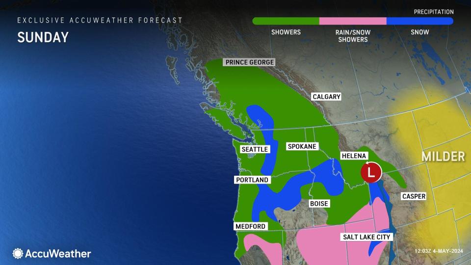
The bulk of the rain will fall from western Washington to Northern California, where a general 1-3 inches will fall into Sunday. However, there will be pockets where 3-6 inches of rain can pour down, especially on the west-facing slopes of the mountains in Oregon.
Enough rain will fall to slow travel along the Interstate 5 corridor and may trigger some rock slides and debris flows in the steep terrain.
 |
Portland, Salem and Eugene, Oregon, typically receive about 2.50 inches of rain in the entire month of May. Rainfall totals can come close to this factoring in the storm this weekend and additional waves of moisture expected to move onshore early this week. Farther south, Medford, Oregon, tends to pick up about 1.30 inches of rain during the month and close to that amount could fall into early week.
In the Cascades, snow levels will dip to near pass levels Sunday morning, when a small amount of slush may occur.
Due to the storm's track slicing to the southeast across California, rain will tend to diminish from north to south across the lower elevations of the Golden State into early Sunday.
Heavy rain fell across parts of Northern California on Saturday, bringing rainfall totals close to 1 inch around San Francisco. Farther east, Sacramento received about half of an inch of rain.
In Sierra Nevada, the storm will have a bigger impact.
"One of the greatest impacts from this storm could be along Interstate 80 at Donner Pass, California, where nearly a foot of snow is likely to slow travel over the weekend, especially Sunday morning," AccuWeather Meteorologist Joseph Bauer said.
From 1-2 feet of snow will fall on the ridges and peaks of the northern and central Sierra Nevada from the storm during the second half of the weekend, which will be a nice pad to the plentiful amount of snow that fell over the winter -- most of which will gradually melt this spring and summer, filling streams, rivers and reservoirs.
 |
A vehicle is covered in snow during a storm on Sunday, March 3, 2024, in Truckee, California. (AP Photo/Brooke Hess-Homeier) |
Snow levels will fall quickly and end up at around 5,000 feet into Sunday morning.
"The storm, essentially an 'inside slider,' is not recognized as bringing heavy precipitation to Southern California in the winter, let alone the spring, and the amount of rain that falls in the region will likely reflect that," AccuWeather Senior Meteorologist Adam Douty said.
"The southern end of the storm will lose steam as it moves into Southern California but could bring enough rain to wet roads in the valleys with more appreciable rain expected in the foothills and mountains," Bauer explained.
Motorists should be alert for slick road conditions in Southern California, where a small amount of rain will mix with the oil and deposits left by traffic from weeks of dry weather. The last time most places in Southern California received rain was in mid-April.
The historical average May rainfall for Downtown Los Angeles is 0.32 of an inch of rain. Last May, 0.55 of an inch fell. Since records began in the mid-1800s, there have been at least two dozen years where no rain fell at all during the month and at least 40 years where less than 0.01 of an inch fell. Meanwhile, the wettest May on record for Downtown L.A. was in 1921, when 3.57 inches fell.
No travel problems from snow are expected over the Southern California passes from the storm.
"For the mountains around the Grapevine, snow levels may dip to 6,000 feet," Bauer said.
Most of the showery precipitation in Southern California will occur into first thing Sunday morning, when it may least affect outdoor plans.
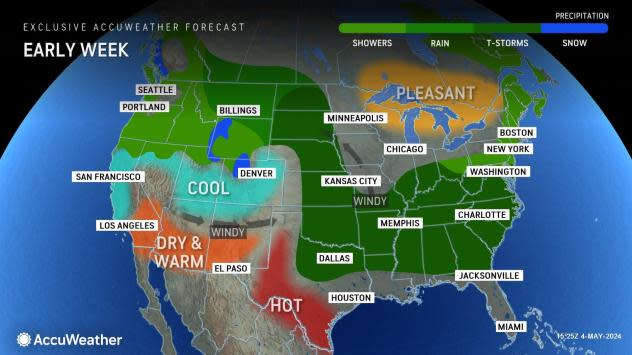
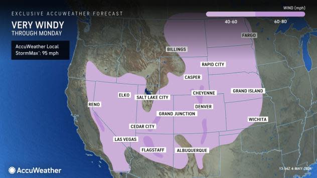
As this storm swings inland, it will tend to become a wind producer over the Intermountain West, Rockies and High Plains. Over some of the ridges and peaks from the Sierra Nevada to the central and southern Rockies as well as the eastern slopes of the Rockies, the AccuWeather Local StormMax™ wind gust is 95 mph.
 |
Winds may become strong enough to cause property damage, knock over trees and bring down power lines through Monday from the Rockies to the High Plains. Where the landscape is dry, the risk of rapidly spreading wildfires will increase.
The same storm is likely to trigger an eruption of severe thunderstorms over the Great Plains on Monday as well.
Want next-level safety, ad-free? Unlock advanced, hyperlocal severe weather alerts when you subscribe to Premium+ on the AccuWeather app. AccuWeather Alerts™ are prompted by our expert meteorologists who monitor and analyze dangerous weather risks 24/7 to keep you and your family safer.
