A postcard from the world’s most bizarre border
Ahead of a BBC Two programme, Dangerous Borders: A Journey Across India & Pakistan, Jack Palfrey recalls a trip to one of the world's most bizarre borders.
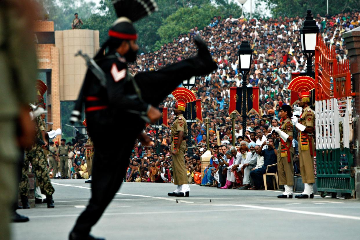
The crowd bursts into a deafening roar as a troop of Indian soldiers emerge into the sun-scorched concrete amphitheatre, clad in pressed Khaki uniforms and ceremonial orange fanned hats.
Spectators shout themselves hoarse, contorting and clenching limbs in fevered anticipation. Mobiles flash, ice creams are thrown and, to my left, a portly gentleman thrusts his fist with such ferocity his face starts to redden.
It’s sunset at the Wagah Border on the Grand Trunk Road, the primary land crossing between the nations of India and Pakistan.
Almost every evening for the last 57 years crowds have flocked here to cram into the world’s only cross-border stadium to watch India's Border Security Force competitively march off against the Pakistan Rangers on opposing sides of the Radcliffe Line.
Spectators shout themselves hoarse, contorting and clenching limbs in orgiastic anticipation
Started in 1959, as a ceremonious show of coordination between the two military forces, the daily border closing event has grown to encompass the sweltering tensions between the two nations. Seemingly this evening would be no different.
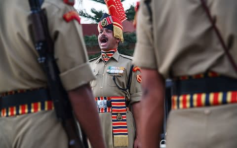
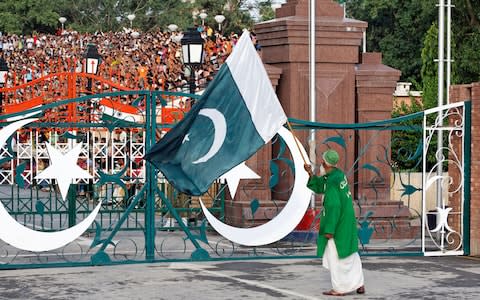
The metallic border gate is slung open, revealing clearly for the first time the outlines of the Pakistan Rangers. Aside from their stark black uniforms, they mirror their Indian counterparts, who are now screeching beneath a giant portrait of their nation’s founding father.
Suddenly an Indian soldier breaks from the pack and begins furiously goose-stepping towards the border, where he is met by his opposing number. There is a long stare, before the two soldiers perform a series of choreographed kicks and ground stomps, which invokes the elegance of ballet along with the aggression and showmanship of wrestling.
It invokes the elegance of ballet and the aggression of wrestling
The crowd springs to their feet. A crazed spectator charges the field but is grabbed by a security guard and slapped around the face. A man behind me places an arm around my neck and almost chokes me in a gesture of comradery.
“Hindustan number one!” He bellows, violently shaking me. His name, I learn, is Aadi. He’s in his mid-20s, with black hair and a mischievous grin. It’s his first time at the festival.
He leans close to me as the crowd momentarily pause for breath.
“One day,” he says, the index and middle finger of his right hand forming the barrel of a gun, which recoils as he ploughs fictional bullets into the Pakistani spectators.
A spectator charges the field but is grabbed by a security guard and slapped
Aadi laughs. I swallow hard, mindful that violence has marred this spectacle in the past. Meanwhile, the chorus of “Hindustan number one” loudens.
As the dipping sun reddens the cinnamon sky, the crescent and star of Pakistan and Indian tricolour are lowered in unison. Both sides of the stadium wail one last time as the senior soldiers abruptly shake hands and the border gate slides shut.
A cooling breeze swirls round the stadium, dissipating any remnant of aggression. On both sides of the border elderly gentlemen with wispy beards converse quietly, teenagers rush to snap selfies with the guards and mothers carry tired children towards the exit.
Yes this wonderfully bizarre ceremony highlights the divide between these two nations, but it highlights their similarities too.
Five more barmy border crossing
1. Erlian: Mongolia-China
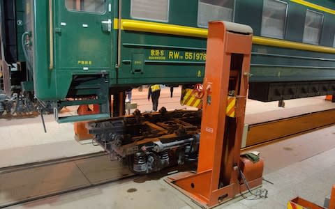
Trains crossing the border between Mongolia and China need to have their wheels changed at the town of Erlian. It might sound like an April fool, but this is no joke; because railway tracks in China are narrower than in Mongolia, all rolling stock must be jacked up and fitted with a new set of wheels (or bogies). It takes several hours to perform this monumental operation and passengers must remain on board throughout.
2. Baarle-Nassau: Netherlands-Belgium
Perplexity prevails in the town of Baarle-Nassau, which is part Dutch and part Belgian. The border between these two countries zigzags through this strange frontier town, carving cafes and restaurants in two, which means you can have coffee with someone while sitting in different countries. To add to the confusion there are Belgian enclaves on the Dutch side and Dutch enclaves on the Belgian side.
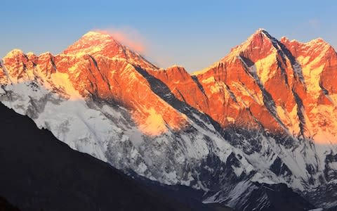
3. Mount Everest: China-Nepal
Those who scale Everest can not only brag of climbing the world’s highest peak, but can also claim to straddle the world’s highest border. That’s because this icy peak is a natural frontier between Nepal and China. There’s no passport control, but the bitter temperatures and fierce winds will ask many questions of you.
4. The Diomede Islands: Russia-USA
Separated by the Bering Strait, which forms a natural border between Russia and the US, the Diomede Islands are comprised of Big Diomede and Little Diomede. Russia owns the former and America owns the latter and as you can imagine, the frontier is frosty in more ways than one (it’s actually illegal to cross the strait). More interesting, though, is the fact that Little Diomede is a day behind its bigger sibling, meaning islanders can look across the water and see the future.
5. The Northwest Angle: USA-Canada
In 1783, The Treaty of Paris established the boundaries between the British Empire and the newly formed United States of America. Trouble is those boundaries were based on dodgy cartography, resulting in what’s known as the Northwest Angle; a little slice of Minnesota in Canada. According to a census in 2010 some 119 citizens live in “The Angle” and they are required to notify US and Canadian border security if they plan on leaving.

